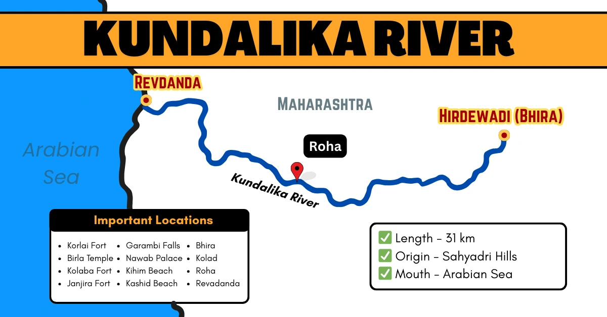
Kundalika River of Maharashtra
The Kundalika River, flowing through the Raigad district of Maharashtra, is a relatively short river with a total length of about 31 kilometers. It originates from the Sahyadri Hills of the Western Ghats near Hirdewadi (Bhira) at an altitude of 820 meters above sea level.
Table of Contents
Quick Overview
| Feature | Details |
|---|---|
| Origin | Sahyadri Hills |
| Total Length | Approx. 31 km |
| District Covered | Raigad |
| Mouth | Arabian Sea near Revdanda |
| Bridges | Revdanda Road Bridge, Roha Bridge |
Origin and Course of Kundalika
The Kundalika River originates in the hills of the Sahyadri range (a part of the Western Ghats) near Hirdewadi (Bhira) village, located approximately 150 km southeast of Mumbai. Emerging at an elevation of 820 meters AMSL, the river begins its journey through steep valleys and thick forests.
- From its source, the river initially flows in a southwest direction until it reaches Patnus village.
- Then, it turns northwestward, flowing through varied terrain before finally merging with the Arabian Sea near Revdanda in the Raigad district.
River Basin
The Kundalika River basin is strategically positioned:
- North: Bounded by the Amba River catchment
- South: Bordered by the Savitri River basin
- East: Flanked by the Western Ghats
- West: Opens into the Arabian Sea
Villages along its course:
- Upper Stretch: Roha, Tareghar, Kumboshi, Ashtami, Zolambe, Gophan, Wavekhar
- Middle Stretch: Shedsai, Mahalunge, Dapoli, Kapori, Kude, Walake
- Lower Stretch: Yesade, Mithekar, Talavali Tarf Umate, Nidi, Agarkot, Salav, Korlai, Revdanda
Note: There are no dams, barrages, weirs, anicuts, or locks on the Kundalika River, allowing the water to flow freely into the Arabian Sea.
White-Water Rafting and Adventure Tourism
The Kundalika River is Maharashtra’s only year-round white-water rafting destination, with Kolad being the center of activity.
Rafting Details:
- Stretch: Around 12–14 km
- Duration: Approximately 2 hours
- Rapids: Grade II and III—ideal for beginners and intermediate rafters
- Best Time: All year, with monsoon (June–Sept) offering the most thrilling experience
Other popular adventure activities include:
- Kayaking
- River crossing
- Ziplining
- Camping along riverbanks
Famous Tourist Sites
| Tourist Sites | Distance from the River (km) |
|---|---|
| Birla Temple | 2 km |
| Korlai Fort | 4 km |
| Kolad (rafting) | 11 km |
| Kashid Beach | 14 km |
| Alibaug Beach | 19 km |
| Kolaba Fort | 19 km |
| Nawab Palace | 28 km |
| Kihim Beach | 27 km |
| Garambi Falls | 31 km |
| Janjira Fort | 36 km |
Bridges Over the Kundalika River
The river is crossed by key transportation links, aiding connectivity in the Raigad region:
- Revdanda Road Bridge – Near the river mouth
- Roha Bridge – Closer to the town of Roha, serving local commuters
Also read: Rivers of India with Map to explore more rivers across the country.