Gangavali River
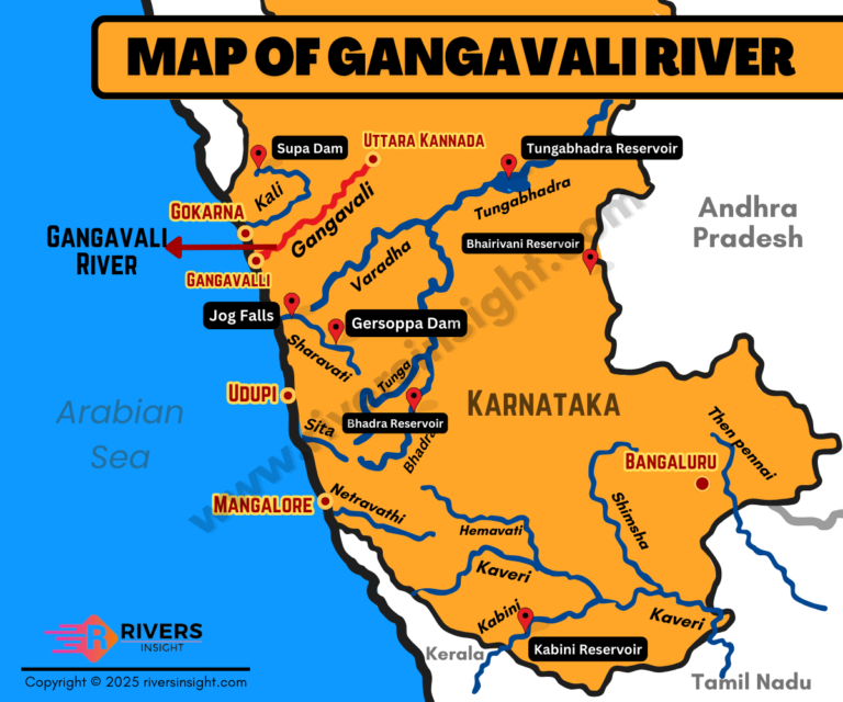
The Gangavali River is also known as the Bedthi River in some parts of Karnataka. It flows mainly through Dharwad and Uttara Kannada districts. The river begins near the Someshwara Temple which is located south of Dharwad.
In the upper stretch it is called Shalmala. It later joins another stream near Kalghatgi and from there it continues its journey towards the west. Further, the total length of this river is around 152 kilometers. It finally meets the Arabian Sea near the Ganga Temple in a village named Gangavalli.
Table of Contents
Quick Facts of Gangavali River
- Origin point: Near Someshwara Temple
- Districts: Dharwad and Uttara Kannada
- Mouth: Arabian Sea near Gangavalli
- Length: Approx 152 km
- Catchment area: Around 3574 sq km
Important Spots Along the River
There is a huge waterfall on this river called Magod Falls. The river drops from a height of about 183 meters here. The first half of the river flows gently but after that it moves through deep valleys and gorges.
Further, a major bridge called Hosur Bridge is built over the river near Gangavalli. This bridge is part of National Highway 66 and plays a key role in connecting Ankola and Kumta.
Tributaries
- Shalmala
- Sonda
- Bedthi (or Bedti)
Many of these tributaries, like Shalmala and Sonda, are also featured in our Rivers of Karnataka article.
Nearby Temples
Many temples can be found in the river’s catchment area. Some of the main ones are:
- Someshwara Temple
- Ganga Temple
- Mari Kamba
- Chandramauleshwara
- Navagraha Teertha
These are visited by people from nearby villages and towns. The village Gangavalli is close to Ankola town. It is around 11 km from Ankola and 4 km from Belambar. Another place called Gokarna, which is a popular tourist and pilgrimage site, is just a few kilometers away from this river.