Satpura Range in India: Map, Mountains, Hills & Highest Peaks
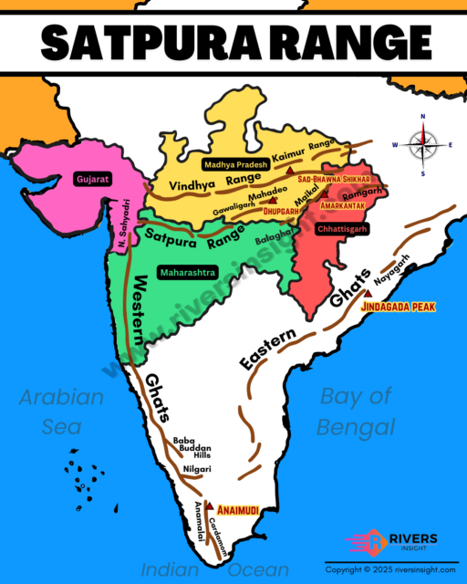
Satpura Range is a mountain range in central India, running parallel to the Vindhya Range in the north and bordered by the Deccan Plateau in the south. It stretches across the states of Madhya Pradesh, Maharashtra, Gujarat, and Chhattisgarh, covering nearly 900 km in an east–west direction. In addition, its highest peak is Dhupgarh (1,350 m) which is located in Mahadeo hills in Madhya Pradesh.
Table of Contents
Etymology and Name
The word Satpura comes from Sanskrit. Sapta means seven and pura means mountains. So, Satpura means “Seven Folds”. The range is said to be named after seven peaks:
- Dhupgarh
- Shikhar
- Mahadeo
- Chota Mahadeo
- Amarkantak
- Bori
- Tapti
In ancient texts like the Ramayana and the Mahabharata, Satpura is also mentioned. Sometimes it is described together with Vindhya as the Vindhya–Satpura Range, because it forms a natural boundary between northern and southern India.
Physical Features of the Satpura Range
- Satpura Range lies in central India, running east–west, and covers parts of Madhya Pradesh, Maharashtra, Chhattisgarh, and Gujarat.
- The range generally has an elevation of 600 to 1,350 metres.
- The highest peak is Dhupgarh (1,350 m), located near Pachmarhi in Mahadeo Hills.
- The range covers nearly 65,000 square kilometres
- The famous Pachmarhi Plateau is also part of the range and is called the “Queen of Satpuras.”
- On the north, the range is bounded by the Narmada River, while on the south flows the Tapti River.
- The mountains are rich in minerals like coal and bauxite.
- Thick forests of teak, sal, and bamboo are found here.
Sub-Ranges of the Satpura Range
The Satpura Range is not a single chain of mountains but a group of smaller hill ranges spread across central India. The main sub-ranges are:
- Mahadeo Hills – Located in Madhya Pradesh, these hills lie to the north of the range. The well-known Pachmarhi Plateau and Dhupgarh Peak (1,350 m) are found here.
- Maikal Range – Found in the eastern part of the Satpuras, mainly in Madhya Pradesh and Chhattisgarh. This range extends towards the Amarkantak Plateau, which is the source of important rivers like the Narmada and Son.
- Rajpipla Hills – Situated in the western part of the Satpuras, in Gujarat. These hills are close to the lower valley of the Narmada River.
Rivers
- Narmada River: Originates from a spring at the Amarkantak Plateau in the Maikal Hills (Madhya Pradesh). It flows westward between the Satpura and Vindhya ranges and drains into the Arabian Sea.
- Tapti River: Begins at Multai in Betul district, Madhya Pradesh, on the southern slopes of the Satpuras. It also flows west and meets the Arabian Sea near Surat (Gujarat).
- Son River: Rises near the Amarkantak Hills (Madhya Pradesh), close to the Narmada’s origin. It flows northeast and joins the Ganga River near Patna (Bihar).
- Wainganga River: Starts in the Mahadeo Hills (Madhya Pradesh). It flows south and later joins the Godavari River.
- Wardha River: Originates in the Satpura Hills (Madhya Pradesh). It flows south, merges with Wainganga, and together they form the Pranhita River, a major tributary of the Godavari.
Together, these rivers make the Satpura Range a watershed region, linking the Ganga basin (Son River), the Godavari basin (Wainganga and Wardha), and the Arabian Sea basins (Narmada and Tapti).
National Parks & Reserves
Satpura region is rich in forests and wildlife. It has several national parks and reserves such as:
- Satpura National Park
- Pench National Park
- Kanha National Park
- Gugamal National Park
- Melghat Tiger Reserve
- Bori Wildlife Sanctuary
- Pachmarhi Biosphere Reserve
- Tadoba Andhari Tiger Reserve
- Sanjay Dubri Wildlife Sanctuary
So, this is all about the Satpura Mountain Range. If you have any queries or wish to suggest additional information, please let us know in the comments.
Thank You.