Pennar River: Origin, Course, Tributaries & Map
The Pennar River, also known as Penna, Pinakini, or Penneru, is one of the prominent rivers in southern India. Originating in the Nandi Hills of Karnataka, it flows through Andhra Pradesh, nourishing vast farmlands before finally draining into the Bay of Bengal near Nellore. Despite being a non-perennial river, it plays a vital role in irrigation, drinking water supply, and hydroelectric generation.
Table of Contents
| Feature | Details |
|---|---|
| Alternate Names | Penna, Pinakini, Penneru |
| Origin | Nandi Hills, Karnataka |
| Mouth | Bay of Bengal, near Nellore |
| Length | 597 km |
| Basin Area | 55,213 sq. km |
| States | Karnataka, Andhra Pradesh |
| Main Uses | Irrigation, Hydropower, Drinking water |
| Not a tributary | Pennar is an independent east-flowing river |
Origin and Course of Pennar River
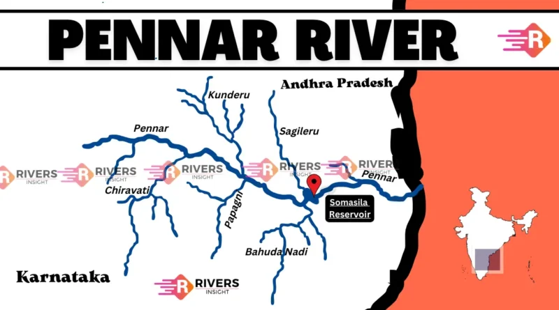
The Pennar River originates from the Nandi Hills in Chikkaballapur district, Karnataka. It flows eastward through the Deccan Plateau, entering Andhra Pradesh, and passing through Anantapur, Kurnool, Kadapa, and Nellore districts before emptying into the Bay of Bengal near Nellore.
It travels approximately 597 kilometers, forming a semi-arid yet agriculturally important river basin.

Geography and Basin Characteristics
- Terrain: Upper basin is rocky and dry; lower basin is fertile with red and black soils.
- Climate: Semi-arid to tropical.
- Vegetation: Sparse in the upper basin, denser near the delta.
- Wildlife: The region is home to the endangered Jerdon’s courser and Indian eagle owl.
Tributaries of the Pennar River
The Pennar River has many tributaries, categorized as left-bank and right-bank tributaries:
Left-Bank Tributaries:
- Jayamangali River: Originates in Karnataka and flows through Tumkur and Chitradurga.
- Kunderu River – From Nallamala Hills, flows through Anantapur.
- Sagileru River – Originates in the Eastern Ghats.
- Cheyyeru River – From Eastern Ghats, passes through Kadapa.
- Papagni River – Flows through Chittoor and Kadapa.
Right-Bank Tributaries:
- Kundu River – Originates in the Nallamala Hills.
- Chitravathi River – Flows through Anantapur.
- Galeru River – From Kurnool to Kadapa.
- Bahuda River – Eastern Ghats origin, flows through Chittoor and Nellore.
Major Dams on the Pennar River
| Dam Name | District | Height | Storage Capacity |
|---|---|---|---|
| Somasila Dam | Nellore | 47 m | 15.42 TMC |
| Kandaleru Dam | Nellore | 49 m | 68.48 TMC |
| Gandikota Dam | Kadapa | 52 m | 3.99 TMC |
| Mylavaram Dam | Kadapa | 48 m | 4.48 TMC |
These dams are essential for irrigation, drinking water supply, and managing seasonal flows.
💡 Did You Know?
The Pennar River was referred to as Pinakini in the Mahabharata and Rigveda, and its basin supported major trade and temple construction during the Vijayanagara Empire.
Ecological & Economic Importance
- Supports agriculture (paddy, cotton, millets).
- Source of drinking water for towns in Rayalaseema.
- Wildlife sanctuary areas lie in its basin.
- Suffers from sand mining, industrial effluents, and monsoon dependence.
FAQs about the Pennar River
Q1. Where does the Pennar River originate?
👉 It originates in the Nandi Hills of Karnataka.
Q2. Which states does the Pennar River flow through?
👉 It flows through Karnataka and Andhra Pradesh.
Q3. Is Pennar a tributary of any major river?
👉 No, it is an independent river that drains into the Bay of Bengal.
Q4. What are its major tributaries?
👉 Jayamangali, Kunderu, Cheyyeru, Papagni, Kundu, and Chitravathi.
Q5. What are the main dams on the Pennar River?
👉 Somasila, Kandaleru, Gandikota, and Mylavaram.
Conclusion
The Pennar River may not be as mighty as the Ganges or Brahmaputra, but it is lifeblood to millions in Rayalaseema and southern Andhra Pradesh. With its historical roots and ecological importance, there is a growing need for sustainable water management and restoration efforts to preserve it for future generations.