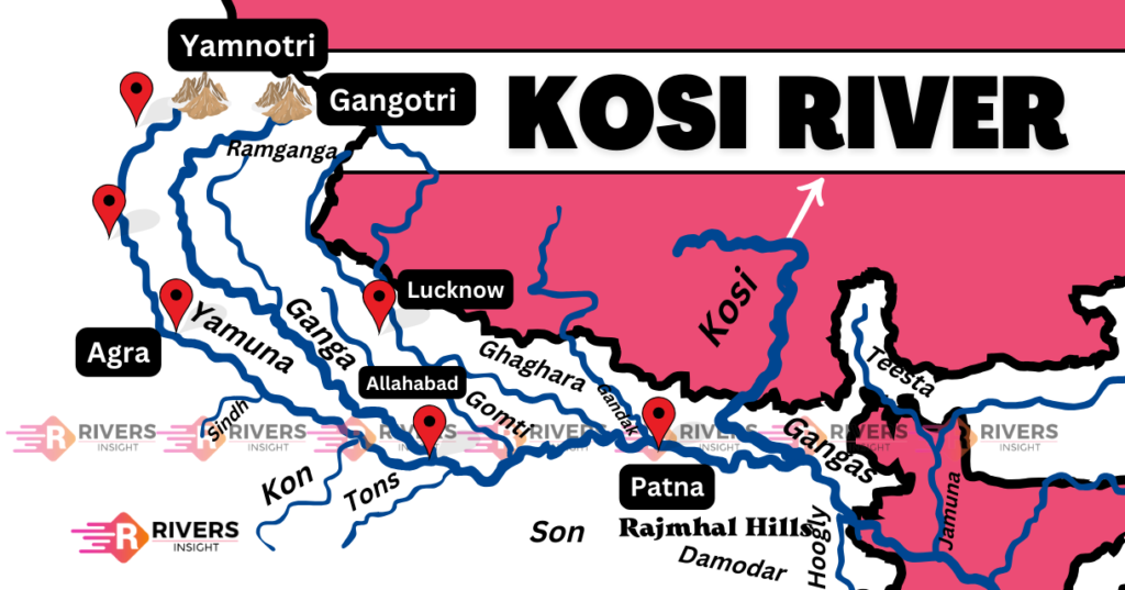
Kosi River: Map, Tribuatries and Dam – Bihar, India
The Kosi River originates from the Himalayan slopes of Tibet and flows onward through China, Nepal, and India as a significant tributary of the Ganges. Its name Saptakoshi is derived from the seven upper tributaries that come together. Moreover, the Kosi River has been known by various names throughout history, including Kausika, which is mentioned in the ancient Hindu scripture the Rigveda.
In this article, we will learn about Kosi River’s origin and geographical features, including its source, length, and drainage basin. We will also explore its course, which flows through the Himalayan foothills and the Indo-Gangetic Plain, and its tributaries, which include several major rivers.
| Origin | Tibet |
| Length | 720 km |
| State | Bihar |
| Also called | Sorrow of Bihar |
| End point | Katihar |
Table of Contents
Geographical Features of Kosi River
The Kosi River stretches for a length of approximately 720 kilometers and has created a vast alluvial fan known as the Kosi Fan, which is one of the largest in the world. In addition, the Kosi River is a perennial antecedent river that existed before the formation of the Himalayas and has continued to flow despite the geological changes that have occurred over time.
Origin and Course
The Kosi River originates in the Himalayan region of Nepal and Tibet, formed by the confluence of three streams:
- Sun Kosi: The Sun Kosi originates in the Tibet Autonomous Region of China, near the town of Tingri.
- Arun Kosi: The Arun River originates in the Himalayas of eastern Nepal, near the town of Tumlingtar.
- Tamur Kosi: The Tamur River originates in the Himalayas of eastern Nepal, near the town of Khandbari.
These three streams converge and flow through a narrow gorge for about 10 km before debouching into the plains near Chatra.
Then it breaks southward through the Siwalik Hills at the narrow Chatra Gorge, about 30 miles (48 km) north of the Indian-Nepalese frontier.
From there, it flows through Nepal for a certain distance before entering Indian territory about 25 km below the Chatra gorge at Hanuman Nagar, where it flows in a sandy track, almost in level plains, before finding its way southwards into the River Ganga through several channels.
Finally, the Kosi River joins the Ganga River at a location called Katihar District, near the village of Katouli, in the state of Bihar, India.
To be more precise, the confluence point is approximately at:
- Latitude: 25.6333° N
- Longitude: 87.3667° E
This location is situated in the Katihar District, about 20 km south of the city of Katihar, and around 300 km northeast of the state capital, Patna.
Map of Kosi River
Drainage Basin
The Kosi River drainage basin covers an area of approximately 74,500 square kilometers, with 11,070 square kilometers lying within the Indian Territory and the remaining 63,430 square kilometers in Nepal and Tibet, China. The basin’s physical characteristics include an elevation range of 8,000 meters in the Himalayas to 100 meters in the plains of Bihar.
The catchment area of the Koshi in Nepal is surrounded by the Bagmati catchment area (supplying waters to the Kathmandu Plateau) to the west, the Gandaki catchment area to the west, and the Kanchenjunga catchment basin in the Himalayas to the east.
Tributaries
The tributaries of the river are:
- Sun Koshi
- Tama Koshi (also known as Tamba Koshi)
- Dudh Koshi
- Indravati
- Likhu
- Arun
- Tamore (also known as Tamar)
Why Kosi River is called the Sorrow of Bihar?
The Kosi River is called the Sorrow of Bihar because it has caused a lot of suffering and damage to the people of Bihar over the years. Here are some reasons why:
- Floods: Often floods, cause damage to homes, crops, and infrastructure. This leads to loss of life, property, and livelihood. For example, in 2008, the floods of the Kosi River impacted over 3 million people and led to more than 250 deaths as well as the displacement of thousands.
- Unpredictable: The river’s course changes frequently, making it difficult for people to prepare for floods. In 2019, the river changed its course suddenly, catching people off guard and causing widespread destruction.
- Destruction: The floods have destroyed entire villages, crops, and infrastructure, leaving people without homes or livelihoods. In 2017, the floods destroyed over 10,000 homes and affected over 100 villages.
- Loss of Life: Many people have lost their lives in the floods. In 2013, more than 100 people died in the floods, and many more were injured.
All these reasons have earned the Kosi River the nickname “Sorrow of Bihar” because it has brought so much pain and suffering to the people of Bihar, making it a symbol of sorrow and suffering.
Dams on the Kosi River
1. Kosi Barrage (Bhimnagar Barrage)
- Location: Bhimnagar, Supaul district, Bihar (near the India–Nepal border)
- Commissioned: 1963
- Purpose: Primarily built for flood control, irrigation, and water management.
- Features:
- Diverts Kosi waters through Eastern Kosi Main Canal for irrigation.
- Protects large areas of northern Bihar from annual floods.
- Jointly operated by India and Nepal under the India–Nepal Kosi Agreement (1954).
2. Sapta Kosi High Dam (Proposed)
- Location: Near Barahakshetra in Sunsari district, eastern Nepal
- Status: Proposed, under study by the India-Nepal Joint Project Office (JPO)
- Purpose:
- Flood control in northern Bihar and eastern Nepal
- Hydropower generation (approx. 2,300 MW)
- Irrigation and navigation
- Key Updates:
- Original height of 337m reduced to 304.8m after environmental and social review (as of 2023).
- Proposed barrage and canal system to support downstream regulation.
- Over 75,000 people may be displaced due to its implementation.
- This multipurpose project is still under review as of 2025, with efforts to finalize the DPR within 30 months.