Adyar River: Map of Chennai & History
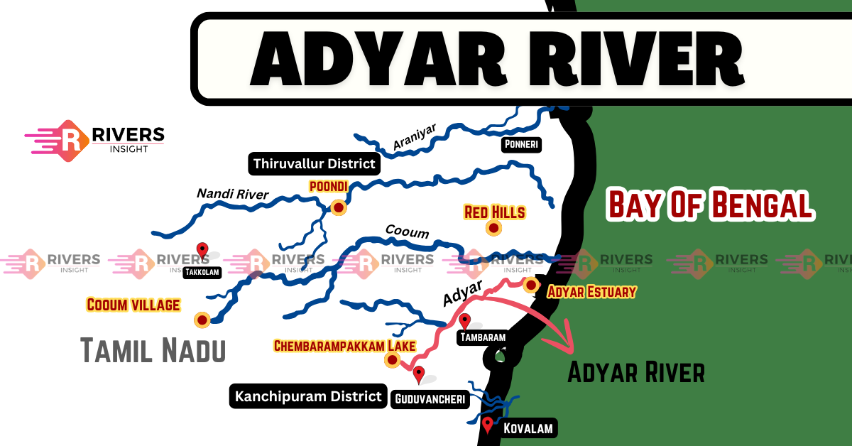
Adyar River is an important river in Chennai. It originates from Chembarambakkam Lake in Kanchipuram district and flows for 42.5 km before finally joining the Bay of Bengal at the Adyar Estuary. Along with the Cooum and Kosasthalaiyar Rivers, it plays a crucial role in shaping the city’s landscape, effectively separating South Chennai from Central Chennai.
Table of Contents
Origin and Course of Adyar
Adyar River originates from the Malaipattu tank near Manimangalam village in Chennai. However, it becomes a prominent stream only when it receives water from Chembarambakkam Lake, one of Chennai’s major water sources.
Course of the River
- The river flows for about 42 km through Kanchipuram, Tiruvallur, and Chennai districts before reaching the Bay of Bengal.
- As it nears the sea, it forms the Adyar Estuary, extending from the Adyar Bridge to the sandbar at the shore, creating a rich ecosystem.
- The Adyar Creek, a backwater formed due to the sandbar, allows tidal water movement between the river and the sea.
Adyar Estuary – A Protected Wildlife Reserve
The Adyar Estuary, covering around 300 acres, is home to diverse bird species and marine life. Recognizing its ecological significance, it was declared a protected wildlife reserve in 1987.
Catchment Area and Drainage Basin
The Adyar River basin covers approximately 860 square kilometers, extending across Chengalpattu, Kancheepuram, Thiruvallur, and Chennai districts. The river originates in the Guduvancheri hills and receives water from various sources, including:
- Manimagalam Tank
- Nandivanam Tank
- Chembarambakkam Tank
Geographical Features
- Total Length: 42 km
- Catchment Area: 860 sq. km
- Elevation at Source: 138 m above sea level (MSL)
- Gradient: Slopes gently eastward toward the Bay of Bengal
Ayacut (Irrigation) Areas
The total river basin covers 860 sq. km, the irrigated land (ayacut) directly benefiting from the river is approximately 185 sq. km (18,452 hectares), distributed as follows:
- Thiruvallur district – 35.23 sq. km (Poonamallee, Thiruvallur taluks)
- Kancheepuram district – 149.29 sq. km (Chengalpattu, Tambaram, Sriperumbudur taluks)
Major Bridges
Several important bridges span the Adyar River, improving connectivity in Chennai.
- Thiru-Vi-Ka Bridge (formerly Elphinstone Bridge) – Originally built during British rule, this bridge connects Adyar and Mylapore. It was later rebuilt and renamed after Tamil scholar Thiru. V. Kalyanasundaram.
- Maraimalai Adigal Bridge (formerly Marmalong Bridge) – First constructed by Armenian trader Coja Petrus Uscan in the 18th century, this bridge links Saidapet and Guindy. It was later rebuilt and renamed after Tamil scholar Maraimalai Adigal.
- Kotturpuram Bridge – A newly constructed bridge connecting Kotturpuram and Adyar, easing traffic congestion.
Historical Significance of the Adyar River
Ancient Origins and Early Use
The Adyar River was originally known as the Vanmiki River and is one of Chennai’s oldest water bodies, alongside the Cooum River and Buckingham Canal. Until the 1950s and 1960s, the river was a clean waterway, widely used for travel, sightseeing, and boating. In the 1940s, boat transport was a major mode of travel along the river.
Bridges and Colonial Influence
- In 1840, the Elphinstone Bridge (now Thiru-Vi-Ka Bridge) was constructed, connecting South Madras to Santhome and Mylapore.
- Before this, the Marmalong Bridge (now Maraimalai Adigalar Bridge) was the only crossing over the Adyar River.
- During the 18th and early 19th centuries, the north bank of the Adyar was a prime European settlement, with British East India Company officials building luxurious houses along the river.
Trivia: Battles Near the Adyar River
- Manimangalam, the river’s point of origin, was a historic battlefield where the Pallavas and Chalukyas fought for control over Kanchipuram.
- The Battle of Adyar occurred near the river between the French East India Company and the Nawab of Arcot’s forces, over control of Fort St. George.
Over time, rapid urbanization and pollution have diminished the river’s former glory, but its historical significance remains deeply embedded in Chennai’s past.