Aravalli Range in India: Mountains, Peaks, and Map
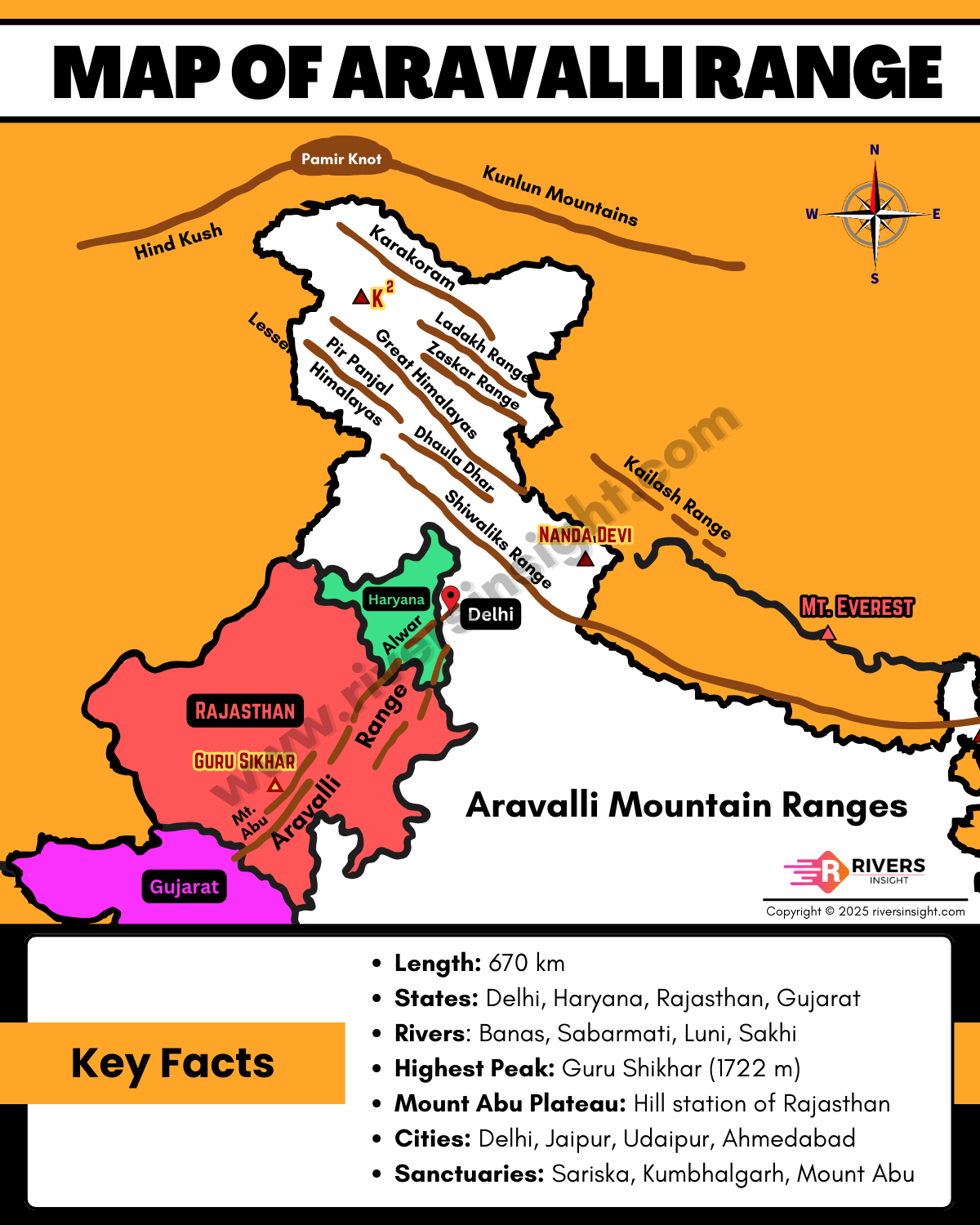
Aravalli Range is the oldest fold mountain in India, located in the northwestern part of the country. The hills start near Delhi in the north and extend till Gujarat in the south. The range runs in a northeast to southwest direction for about 670 km, passing through Delhi, Haryana, Rajasthan, and Gujarat.
Table of Contents
Physical Features of the Aravalli Mountains
- The Aravalli Mountains do not form one long chain. They appear as groups of hills, ridges, and plateaus spread across northwestern India.
- Height of these hills ranges between 300 to 900 metres.
- The highest peak is Guru Shikhar (1722 m), located on the Mount Abu Plateau in Rajasthan. Mount Abu is also the only hill station of the state and a popular tourist spot.
- Geologically, the Aravalli Range is very old and belongs to the Precambrian era, making it one of the oldest fold mountains in the world.
- They are rich in minerals such as copper, zinc, and marble.
- This range acts as a natural barrier, helping to stop the eastward spread of the Thar Desert.
Aravalli Range – India Map

Formation of the Aravalli Mountain Ranges
Aravalli Mountains were formed about 670 million years ago during the Precambrian era. They are one of the oldest fold mountains in the world, even older than the Himalayas.
These mountains were formed when huge land blocks slowly pushed against each other, and the rocks in between bent and lifted, forming fold mountains. Over time, these became the ridges and plateaus of the Aravallis.
Over time, the action of rain, wind, and rivers gradually wore down the peaks, turning them into the rounded hills and broken ridges we see today.
Rivers Originating from Aravalli
Several rivers rise from the Aravalli hills, including:
Importance of the Aravalli Mountains
- The Aravalli Mountains act as a natural barrier, preventing the eastward spread of the Thar Desert.
- They are rich in minerals like copper, zinc, and marble, which have been used for mining and building for centuries.
- The mountains are home to several wildlife sanctuaries and national parks, such as Sariska, Ranthambore, and Keoladeo Ghana Bird Sanctuary, which protect wildlife and attract tourists.
- Rivers originating from the Aravallis provide water for nearby areas.
- They also have tourist attractions like Mount Abu, ancient temples, and scenic hills.
For any suggestions or updates regarding rivers, peaks, sanctuaries, or other relevant information, please provide your comments below.


