Baitarani River: Map, Origin and Drainage Basin
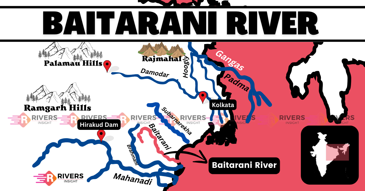
Baitarani River is an important east-flowing river in eastern India, primarily flowing through Odisha and partially through Jharkhand. It originates from the Gonasika Hills in Keonjhar district, Odisha, at an elevation of 900 meters above sea level and travels approximately 360 km before draining into the Bay of Bengal.
Table of Contents
Origin and Course of Baitarani River
Baitarani River originates from the Gonasika Hills in the Keonjhar district of Odisha at an elevation of 900 meters above sea level. At its source, it first flows underground through a small stream called Guptaganga before emerging again, making the site sacred.
In its upper reaches, the river forms a natural boundary between Odisha and Jharkhand before turning northeast for about 80 km. It then changes direction southeast and flows for another 170 km, passing through Jajpur district.
Upon reaching Anandpur, it enters the coastal plains and creates a deltaic zone below Akhuapada. As the river progresses further eastward, it joins the Dhamra River before finally emptying into the Bay of Bengal.
Districts Covered by the Baitarani River
Districts collectively form the Baitarani River basin are:
- Keonjhar
- Mayurbhanj
- Jajpur
- Kendrapada
- Angul
- Bhadrak
- Balasore
Drainage Basin
The Baitarani River basin covers a significant portion of Odisha and a small part of Jharkhand.
Geographical Coverage:
- Total Basin Area: Approximately 12,790 sq. km
- States Covered:
- Odisha (94.8%)
- Jharkhand (5.2%)
The River basin is geographically bounded by several important river basins and water bodies:
- South and West: Brahmani River basin
- North: Subarnarekha River basin
- East: Burhabalang River and the Bay of Bengal
The Baitarani River basin lies in the subtropical monsoon climate zone, where it receives an average annual rainfall of 1,250 mm to 1,500 mm. Notably, around 80% of this rainfall occurs during the monsoon season (June to September), making the river highly dependent on seasonal precipitation.
In terms of land use, about 52% of the basin is covered by agricultural land, while water bodies make up around 3%. The upper catchment area is largely hilly, whereas the lower region transitions into fertile plains, supporting extensive farming.
Moreover, the river follows a dendritic drainage pattern, which contributes to its vulnerability to flash floods, particularly in Jajpur, Bhadrak, and Kendrapada districts.
Tributaries of Baitarani River
The river has 65 tributaries (35 from the left, 30 from the right).
Major Tributaries
- Left-Bank Tributaries: Deo, Kanjhari, Musal, Arredi, Siri, Kukurkata, Budhi, Ambajhara, Remal
- Right-Bank Tributaries: Salandi, Gahira, Kusei
Major Dams
- Salandi Dam
- Kanjhari Dam
- Remal Irrigation Project
So, this is all about the Baitarani River. If you have any queries, additional information, or thoughts to share, feel free to drop a comment below!