Bhogdoi River: Map and Origin
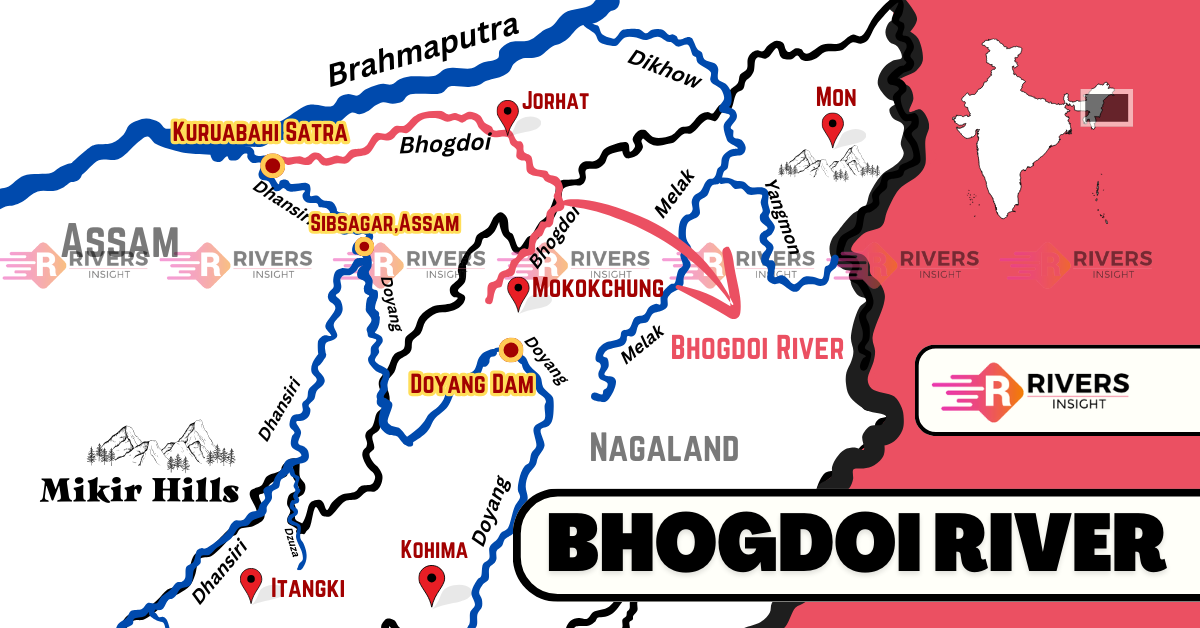
Bhogdoi River is an important south-bank tributary of the Brahmaputra River, flowing through Nagaland and Assam. It originates from the Mokokchung district in the north hills of Nagaland, where it is locally known as Tsujenyong Nala. Changing names along the way, it covers a total length of 160 km, becoming Gelabill before finally joining the Dhansiri River at Kuruabahi Satra Village, Assam.
Table of Contents
Origin and Course of Bhogdoi River
Bhogdoi River originates from the Mokokchung district in the northern hills of Nagaland, where it is locally known as Tsujenyong Nala. As it flows downstream, the river changes direction multiple times and adopts different names along its course.
The river initially flows northeast to southwest for about 25 km, then turns southwest to northeast and is referred to as Tsurongor or Desoi in this stretch. After covering another 25 km, it changes direction northward for 16 km, eventually flowing northwest for 32 km to reach Jorhat district, Assam, where it takes the name Gelabeel. From there, it continues northwestward for 60 km before finally joining the Dhansiri River at Kuruabahi Satra Village, Assam, and ultimately merging with the Brahmaputra River.
Key Locations
- Mokokchung District (Nagaland) – Origin point, called Tsujenyong Nala
- Tsurongor/Desoi – Name of the river in its early course
- Jorhat District (Assam) – Name changes to Gelabeel
- Kuruabahi Satra Village (Assam) – Confluence with Dhansiri River
The total length of the Bhogdoi River is 160 km, with 95 km in the plains and 65 km in the hills. Throughout its journey, it plays a crucial role in shaping the geography and hydrology of Nagaland and Assam.
Tributaries of Bhogdoi River
Bhogdoi River receives water from multiple left-bank tributaries:
- Junka River – Length: 17 km, Catchment Area: 42 sq. km
- Toku River – Length: 12.5 km, Catchment Area: 23 sq. km
- Kakodonga River – Length: 70 km, Catchment Area: 950 sq. km
These tributaries are essential in maintaining the water volume of the Bhogdoi River, especially during the monsoon season.
Key Towns and Villages Along the Bhogdoi River
- Jorhat – The largest town on the riverbanks, with a population of 2,20,534 (Census 2011).
- Duliagaon
- Purana Gayangaon
- Sonali Jayanti Nagar
- Choladhara
- Kakotigaon
- Kushal Nagar
- Barbheta
- Rajatiyagaon
Among these, Jorhat is the most significant town, serving as a major commercial and cultural center in Assam. However, rapid urbanization and pollution from these settlements have contributed to the environmental degradation of the Bhogdoi River.
Environmental Issues and Pollution
Unfortunately, the Bhogdoi River is one of the most polluted rivers in Assam and ranks 351st among polluted rivers in India. Various human and industrial activities have significantly degraded its water quality.
Major Environmental Concerns
- Pollution from coal mining in Nagaland, leading to high levels of manganese in the water
- Industrial and residential waste discharge into the river, reducing water quality
- High Biological Oxygen Demand (BOD), indicating less oxygen for aquatic life
- Encroachment along riverbanks, making the river narrower and increasing waste accumulation
- Human activities such as open defecation, cremation, and garbage disposal contaminating the water
- Siltation reduces the river’s carrying capacity, increasing the risk of floods
These issues threaten aquatic biodiversity, impact fishing communities, and pose a serious health risk to local populations.
What do you think can be done to save the Bhogdoi River? Share your thoughts in the comments below!