Brahmaputra River System with Map & Tributaries
The Brahmaputra River System is one of Asia’s longest and most important river systems. Originating from the Tibetan Himalayas, it flows through China, India, and Bangladesh.
Further, it covers approximately 2,900 kilometers and ultimately merges with the Ganga and Meghna rivers before emptying into the Bay of Bengal. Although, its name, Brahmaputra, translates to “Son of Brahma” in Sanskrit, signifying its revered status in Hindu mythology.
In this article, we will explore the Brahmaputra River system in detail, focusing on its geographical features, tributaries, and other key aspects. Let’s start with the Brahmaputra’s geographical features and unique characteristics.
| River | Brahmaputra |
| Origin | Tibet |
| Length | 2900 km |
| Largest River Island | Majuli Island |
| Empty in | Bay of Bengal |
Table of Contents
Geographical Features of Brahmaputra River
Origin of the Brahmaputra
The Brahmaputra River originates in the Baghirath glacier, located in the Kailash range near Manasarovar Lake in Tibet’s northern Himalayas. This is located approximately 5,000 meters (16,400 feet) above sea level, marking the beginning of the river’s long journey.
Course
The Brahmaputra River originates as the Yarlung Zangbo River in Tibet and flows eastward. As it enters India, it changes its course to flow southwards, and then southwestwards. This remarkable river journey spans approximately 2900 kilometers in total.
Out of this distance:
- Around 1700 kilometers lie within Tibet.
- Approximately 900 kilometers pass through India.
- About 300 kilometers flow through Bangladesh.
In Tibet, the Brahmaputra River is also known as the Tsangpo River in certain areas. As it navigates through the Himalayas and enters Arunachal Pradesh, it carves a deep gorge near Namcha Barwa, showcasing nature’s raw beauty.
Upon entering India, the Brahmaputra River is known by the names Siang and Dihang. The Siang River, as it flows through Arunachal Pradesh, traverses steep gorges and dense forests before reaching the plains of Assam.
In Assam, the Siang River merges with the Dibang and Lohit Rivers to form the mighty Brahmaputra River. This combined river flows through the states of Assam and Meghalaya before reaching Bangladesh near Dhubri or Goal Para.
In Bangladesh, the Brahmaputra River takes on the name Jamuna River. It merges with the Ganges and Meghna Rivers before finally emptying into the Bay of Bengal. Throughout its course, the Brahmaputra River passes through changing landscapes and diverse ecosystems, including high mountains, deep gorges, wetlands, and floodplains. Its flow is highly seasonal, with monsoon rains causing frequent floods in the river basin, impacting the lives of those living nearby.
World’s Largest: Majuli Island
Majuli Island, located in the Brahmaputra River in the Indian state of Assam, is the world’s largest river island. The island has many Vaishnavite monasteries called “satras,” which are important for Assamese arts, culture, and religion. Even though it deals with problems like erosion and flooding, Majuli still draws people with its beauty and heritage.
Cities Along the Course
Several major cities along its route accompany the Brahmaputra River:
India:
- Guwahati
- Dibrugarh
- Tezpur
- Jorhat
- Silghat
- Goalpara
Bangladesh:
- Dhaka
- Jamalpur
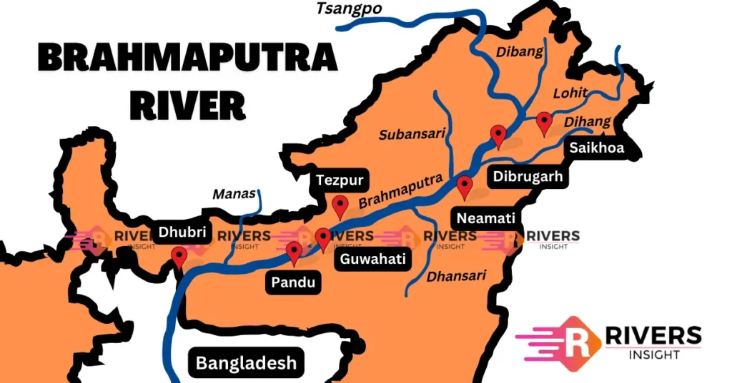
Map of Brahmaputra River

Tributaries of Brahmaputra River
The Brahmaputra River, one of the key rivers in Asia, gains its strength from a network of tributaries originating from diverse regions. These smaller rivers play a crucial role in shaping the flow and character of the Brahmaputra as they merge with it along its course.
Right Bank Tributaries of Brahmaputra River
- Lohit
- Dibang
- Subansiri
- Dhansiri
- Manas
- Sankosh
- Teesta
Left Bank Tributaries of Brahmaputra River
- Burhidihing
- Desang
- Dikhow
- Dhansiri
- Kopili
Different Names of the Brahmaputra River
The Brahmaputra River has various names throughout its course:
- Yarlung Zangbo River: This is the name of the Brahmaputra River in Tibet.
- Tsangpo River: Another name for the Brahmaputra in certain parts of Tibet.
- Siang River: Upon entering India, the Brahmaputra is initially known as the Siang River in Arunachal Pradesh.
- Dihang River: Another name for the Brahmaputra in Arunachal Pradesh.
- Brahmaputra River: This is the widely recognized name of the river as it flows through India.
- Jamuna River: Upon entering Bangladesh, the Brahmaputra is known as the Jamuna River.
- Brahmaputra Meghna Ganges Delta: This name refers to the combined delta formed by the Brahmaputra, Meghna, and Ganges Rivers in Bangladesh.
Major Dams
- Subansiri Lower Dam: Located on the Subansiri River in Assam.
- Kameng Dam: Situated on the Kameng River in Arunachal Pradesh.
- Doyang Dam: Found on the Doyang River in Nagaland.
- Kopili Dam: Located on the Kopili River in Assam.
- NEEPCO Dam: Positioned on the Dikrong River in Arunachal Pradesh.
- North Karimganj Dam: Situated on the Barak River in Assam.
- Karbi Langpi Dam: Found on the Langpi Dehang River in Assam.
These dams play significant roles in hydroelectric power generation, irrigation, and flood control, contributing to the socio-economic development of their respective regions in Northeast India.
India-China Relations on the Brahmaputra River
India and China share interests and concerns regarding the Brahmaputra River, both countries have agreements and mechanisms in place to address issues related to water sharing, hydroelectric projects, and flood management along the Brahmaputra’s course.
China’s development of dams and diversion projects on the upper reaches of the Brahmaputra has raised concerns in India about potential impacts on downstream water flow, agriculture, and livelihoods. India has sought greater transparency and information sharing from China regarding its projects on the river.
Despite occasional tensions, both countries have engaged in bilateral dialogues and established mechanisms like the Expert Level Mechanism (ELM) to address water resource management issues. Through such mechanisms, India and China aim to foster cooperation, enhance data sharing, and mitigate potential risks associated with development activities on the Brahmaputra River.


Infinitely grateful! 💯