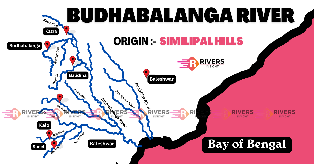
Budhabalanga River with Map
The Budhabalanga River is a significant east-flowing river in the Indian state of Odisha. It has a total length of approximately 198 kilometers. Initially, it originates from Simlipal in the Mayurbhanj district and then flows through the heart of Odisha before eventually emptying into the Bay of Bengal.
Table of Contents
Origin and Course of Budhabalanga River
The Budhabalanga River originates from Similipal hills, where it cascades in double falls in the Barehipani area. From there, it flows northwards, passing through the village of Karanjipal. As it continues its course, it shifts towards the northeast, running parallel to the broad gauge Rupsa-Bangiriposi Railway line until it reaches the village of Jhankapahadi.
At Jhankapahadi, the river changes direction, flowing southwards and intersecting with the Katra nala, which descends from the northwest. Along its path, it is joined by two significant tributaries:
- Palpala: A hill stream originating from the Similipal hills.
- Chipat: Another hill stream rising from the same region.
As the Budhabalanga River continues its journey, it flows through the town of Baripada and passes by the ancient ruins of Haripur, once the capital of Mayurbhanj.
Nearby, the river valley contains important Paleolithic and Neolithic sites. The river features steep banks, and after crossing into the Balasore district, it flows past the town of Balasore, located on its right bank.
Finally, the Budhabalanga River completes its journey by emptying into the Bay of Bengal.
The Budhabalanga River flows through two key districts:
- Mayurbhanj: The river originates in the Similipal hills and flows through this district, passing significant locations such as Baripada.
- Balasore: After crossing into this district, the river flows past the town of Balasore before reaching its final destination.
Tributaries
The Budhabalanga River has several important tributaries, including Palapala, Sunei, Kalo, Sanjo, Deo, Gangahari, and Katra.
- Palapala River The Palapala River originates from Kharimatia pahar and has a weir at Baladiha that irrigates 3880 Ha of land.
- Sunei River: The Sunei River flows into the Budhabalanga River from the right side and originates from Gagua Pahar at an elevation of 499m. It has a dam at Salchua and four tributaries: Kalo, Sanjo, Gangahari, and Targana.
- Kalo River: The Kalo River originates from the Similipal Hills, has a catchment area of 151 sq. km, and is 27 km long. It has a dam that irrigates 2400 Ha in Rabi and 4800 Ha in Kharif.
- Sanjo River The Sanjo River is a left tributary of the Sunei River, has a catchment area of 120 sq. km, and originates from the Similipal Hills.
- Deo River The Deo River originates from the Similipal Hill range, flows southeast, and is a tributary of the Sanjo River. It drains a catchment area of 94 sq. km.
- Katra River The Katra River originates from Bhimahanda and has a catchment area of 208 sq. km.
- Gangahari River The Gangahari River is a left tributary of the Sunei River, originates from Gurusadar Pahar in the Similipal hills, and is 61 km long.
Also Read: Peninsular Rivers
Similipal
The Simlipal is intimately connected to the Budhabalanga River and is a unique gem featuring the largest compact sal-bearing forest while serving as a Tiger Reserve, Sanctuary, and Biosphere Reserve. Further, it is home to the largest potential breeding population of tigers in the Eastern Ghats, and remarkably, it is the only Tiger Reserve to have black (melanistic) tigers.
The park is also a significant watershed, feeding major rivers like the Budhabalanga, Baitarani, Salandi, and numerous perennial rivulets. Furthermore, it is a hotspot of biodiversity, featuring a fascinating mix of floral and faunal elements from both the Western Ghats and Eastern Himalayas.