Colorado River: Map, Route, Origin, States, and Tributaries
The Colorado River is one of the most iconic rivers in the United States, flowing through the arid landscapes of the southwest and shaping some of North America’s most dramatic natural features, including the Grand Canyon. Stretching about 1,450 miles, this river is vital to both the U.S. and Mexico.
| Feature | Detail |
|---|---|
| Origin | Rocky Mountain National Park, CO |
| Length | ~1,450 miles |
| Ends At | Gulf of California, Mexico |
| U.S. States Crossed | 7 |
| Largest Tributary | Green River |
| Basin Size | ~250,000 sq mi |
| Major Cities Dependent | Phoenix, Las Vegas, Denver |
Where is the Colorado River Located?
The Colorado River is located in the southwestern United States, beginning in the Rocky Mountains of Colorado and flowing southwest through seven U.S. states before reaching Mexico.
Colorado River on Map
The Colorado River Basin covers around 250,000 square miles and is divided into:
- Upper Basin: Colorado, Utah, Wyoming, New Mexico
- Lower Basin: Arizona, Nevada, California
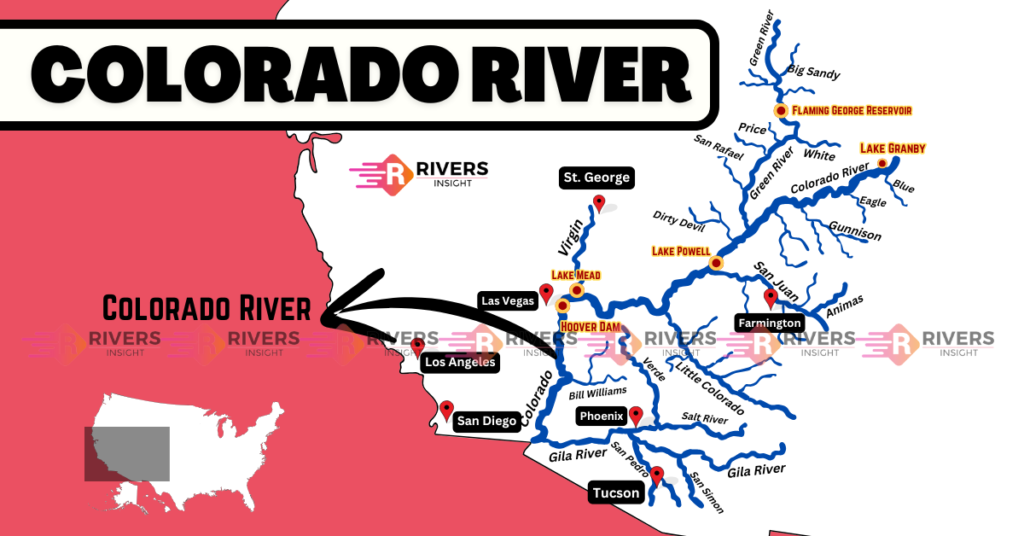
Path of the Colorado River
Step-by-Step Route:
- Starts: Rocky Mountain National Park, Colorado
- Flows Through:
- Colorado
- Utah
- Arizona
- Along Nevada–Arizona and California–Arizona borders
- Into Mexico
- Ends: Gulf of California (Mexico)
States the Colorado River Runs Through
The Colorado River flows through or forms borders for the following seven U.S. states:
- Colorado
- Utah
- New Mexico (via tributaries)
- Wyoming (via tributaries)
- Arizona
- Nevada
- California
Major Features Along the Route
- Grand Canyon (Arizona)
- Lake Powell (Glen Canyon Dam)
- Lake Mead (Hoover Dam)
Tributaries of the Colorado River
Major tributaries include:
- Green River
- San Juan River
- Little Colorado River
- Gunnison River
- Dolores River
- Gila River
- Yampa River
- Virgin River
- White River
Length, Width, and Flow
Length
- Approximately 1,450 miles
Width
- ~50 feet at the headwaters
- ~200 feet near Grand Junction, Colorado
Depth & Flow Rate
- Up to 30 feet in the Grand Canyon
- Lees Ferry: ~8 million gallons/minute
- Mouth: ~2 million gallons/minute
Cities on the Colorado River
Some key cities located along or near the river or within its basin:
- Phoenix, AZ
- Las Vegas, NV
- Yuma, AZ
- Grand Junction, CO
- Moab, UT
- Duchesne, UT
- Boulder City, NV
- Needles, CA
Dams and Reservoirs
| Dam | Reservoir | State(s) |
|---|---|---|
| Hoover Dam | Lake Mead | Nevada–Arizona |
| Glen Canyon Dam | Lake Powell | Arizona–Utah |
| Flaming Gorge | Flaming Gorge | Utah |
| Navajo Dam | Navajo Lake | New Mexico |
| Parker Dam | Lake Havasu | Arizona |
| Davis Dam | Lake Mohave | Arizona–Nevada |
| Blue Mesa Dam | Blue Mesa Res. | Colorado |
| Imperial Dam | N/A | Arizona–California |
Colorado River in North America
On the North America map, the river stands out in the southwestern U.S. and northwestern Mexico. It’s one of the most engineered and utilized river systems on the continent.
Colorado River in Mexico
The river flows into Mexico and ends in the Gulf of California. Under a 1944 treaty, the U.S. is required to deliver 1.5 million acre-feet of water annually to Mexico.
Are There Two Colorado Rivers in the USA?
Yes. Apart from this major river, there’s another Colorado River in Texas, which is a separate and unrelated river that flows into the Gulf of Mexico.
Read Next River: Mississippi River in USA