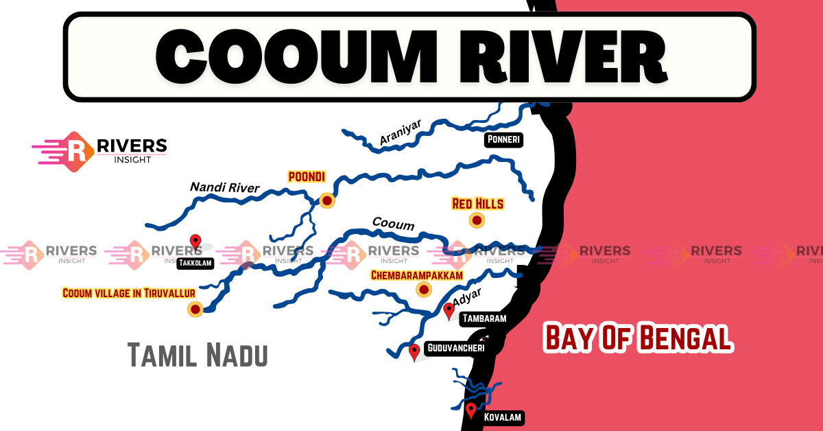
Cooum River: Map of Chennai, Tamil Nadu
Cooum River is one of the three major rivers flowing through Chennai, Tamil Nadu, India. It originates from Cooum village in Tiruvallur district and travels approximately 72 km before finally draining into the Bay of Bengal near Marina Beach, Chennai. Further, the river is sometimes referred to as the Thiruvallikenni River and was known as Koovam in ancient Tamil literature.
Table of Contents
Origin and Course of Cooum River
Cooum River originates from Cooum village in Tiruvallur district, Tamil Nadu, about 70 km west of Chennai. It has a total length of 72 km, out of which 42 km flows through rural areas, while the remaining 30 km passes through urban and semi-urban regions.
As the river enters Chennai, it flows through three major corporation zones—Kilpauk, Nungambakkam, and Triplicane—covering a total distance of 16 km within the city. Further, it passes through key areas such as Arumbakkam, Choolaimedu, Chetpet, Egmore, and Chintadripet before reaching The Island Grounds, where it briefly splits into two channels before reuniting. Finally, the river drains into the Bay of Bengal near Marina Beach, Chennai.
Notably, along with the Adyar River to the south and the Kosasthalaiyar River to the north, the Cooum River trifurcates Chennai, dividing North Chennai from Central Chennai.
Major Bridges Over the Cooum River
Several important bridges were built on the river, including:
- Napier Bridge
- Harris Bridge
- Commander-in-Chief Road Bridge
- College Road Bridge
- Spur Tank Bridge
- Aminjikarai Bridge
Historical Significance of Cooum River
The Cooum River held great strategic importance due to its proximity to Manarpha Port (modern-day Mylapore), a major trade hub between South India, Sri Lanka, and the Roman Empire. Roman merchants visited the port to trade textiles, gemstones, and spices for gold, silver, and fine wine. Archaeological finds like Roman and Chinese coins and ancient wine jars confirm this historical connection.
In the 18th century, Pachaiyappa Mudaliar, a famous philanthropist, bathed in the Cooum before praying at Komaleeswarar Temple. To control flooding, the river was linked to the Elambore River in the 1700s, with a bridge built in 1710.
Ancient scriptures mention that Cooum once originated in Dharmapuri, but tectonic shifts shortened its course to the Tiruvallur district. It was also believed that bathing in its waters led to salvation.
Until the early 20th century, Cooum was clean and navigable, but rapid urbanization, sewage disposal, and industrial waste turned it into one of India’s most polluted rivers. The 2004 tsunami briefly cleared its waters, but pollution quickly returned. However, some rural areas still rely on its cleaner upper stretches for drinking water.