Ichamati River with Map of West-Bengal
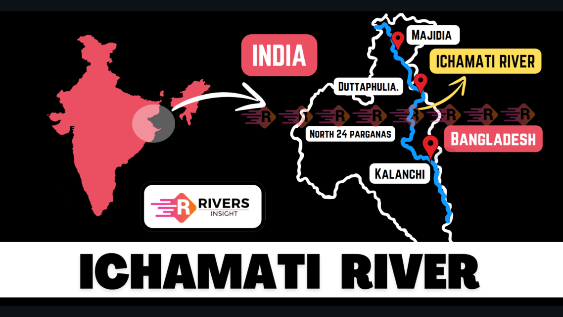
The Ichamati River is a transboundary river that flows through both India and Bangladesh, acting as a natural boundary between the two countries. It begins as a bifurcation of the Mathabhanga River, which is a branch of the Padma River in Bangladesh. The river flows for about 208 kilometers, crossing into West Bengal, India.
Table of Contents
Origin and Course of Ichamati River
The Mathabhanga River starts on the right bank of the Padma River at Munshiganj, in Kushtia District of Bangladesh. As it flows downstream, the Mathabhanga River bifurcates at Majidia in Nadia District, West Bengal, India, dividing into two rivers:
- Ichamati
- Churni
The total length of the Ichamati River is 208 kilometers (129 miles). After its bifurcation, the Ichamati River flows through India for about 19.5 kilometers before entering Bangladesh near Mubarakpur. In Bangladesh, it flows for 35.5 kilometers and then re-enters India at Habaspur Village, near Duttaphulia.
The river continues to form a natural boundary between India and Bangladesh for approximately 21 kilometers, starting from Angrail to Kalanchi, and again from Goalpara to the Kalindi-Raimangal outfall, where it meets the Bay of Bengal.
Historical Course Shifts
Historically the Ichamati River was part of a Bhairab river system. The Bhairab River once flowed from the Ganges and passed through the Jalangi River. It then moved eastward towards Faridpur.
Initially, the Mathabhanga and its tributaries including the Ichamati flowed in a southeasterly direction. However, due to a natural shift caused by local subsidence, the rivers changed course and started moving in a southwesterly direction. This shift occurred before 1750, and the rivers have continued on their current path.
Major Locations Along the Ichamati River
- Munshiganj (Kushtia District, Bangladesh): The starting point of the Mathabhanga River, from which Ichamati originates.
- Majidia (Nadia District, India): The bifurcation point where the Ichamati and Churni rivers split.
- Mubarakpur (Nadia District, India): The river flows into India and continues through the region.
- Duttaphulia (Nadia District, India): The river re-enters India after flowing through Bangladesh.
- Angrail (West Bengal, India): The river marks part of the international boundary here.
- Kalanchi (West Bengal, India): Another key point on the international border.
- Hasnabad (North 24 Parganas, India): The point where the Ichamati joins the Kalindi River.
- Debhata (Satkhira District, Bangladesh): The river flows into Bangladesh and reaches its confluence with the Kalindi.
Key Geographical Features
- Length: 208 kilometers
- Starting Point: The river bifurcates from the Mathabhanga River in Bangladesh, near Mahjdia village in West Bengal, India.
- Confluence: It joins the Kalindi River near Hasnabad in India and Debhata in Bangladesh.
- Oxbow Lakes: As the Ichamati meanders, it forms several oxbow lakes.
Recent Developments
On 1 August 2022, a major announcement was made by the Chief Minister of West Bengal, Mamata Banerjee, regarding the formation of a new district named Ichamati District. This district is named after the river and is set to be created by bifurcating the North 24 Parganas district.
What are your thoughts on this article about the Ichamati River? Feel free to share your feedback or any additional insights in the comments below!