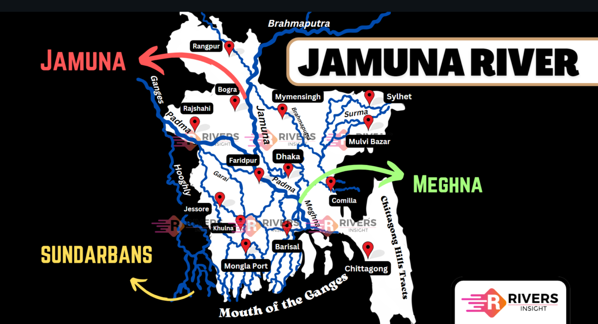
Jamuna River: Map of Bangladesh
The Jamuna River is the second-largest river in Bangladesh and one of the largest rivers in the world. It is the downstream course of the Brahmaputra River which originates in Tibet and flows through India before entering Bangladesh. The Brahmaputra continues southeast from Bahadurabad and the stretch between Bahadurabad and Aricha is called the Jamuna.
To better understand the Jamuna River’s flow, geography, and tributaries, you can refer to the Jamuna River map included in this article. The map illustrates its course, from its origin in Tibet through India and into Bangladesh, highlighting key regions and tributaries along the way.
Table of Contents
Origin and Course of Jamuna River
The Jamuna River originates from the Chemayung-Dung glacier in Tibet at 31’30’N and 82’0’E, about 145 km from Lake Mansarovar and Mount Kailas. It initially flows as part of the Brahmaputra River, known as the Dihang River as it passes through the Assam Himalayas into India. The river then enters the Bengal Plain and continues into Bangladesh through Kurigram district.
The stretch of the river between Bahadurabad and Aricha in Bangladesh is called the Jamuna. It formed after a major earthquake and flood between 1782-1787, which changed the course of the Brahmaputra. Before the event, the river flowed as the Brahmaputra, but afterward, the river became the Jamuna. The river flows for 276 km in Bangladesh, with 205 km specifically identified as the Jamuna.
As the Jamuna flows southward, it merges with the Padma River at Goalundo, forming one of the largest river systems in the world. The Padma is the main distributary of the Ganges, and their confluence with the Jamuna leads to the formation of the Meghna River, which eventually empties into the Bay of Bengal.
Tributaries of the Jamuna River
- Dudhkumar River
- Dharla River
- Teesta River
- Karatoya-Atrai System
Map of River Jamuna in Bangladesh
Characteristics of the Jamuna River
The Jamuna River is renowned for its vast and shifting channels. It is a multi-channel braided river with a width that ranges from 3 km to 20 km, averaging 10 km. During the monsoon season, it can expand to over 5 km.
Catchment Area
The Jamuna River has a catchment area of approximately 583,000 sq km, with 47,000 sq km located within Bangladesh. The river plays a key role in the region’s hydrology, especially during the monsoon season. It has an average monsoon discharge of 40,000 cumec, making it one of the largest rivers by volume alongside the Amazon, Congo, and Yangtze.
Flooding and Erosion
Flooding is a frequent event along the Jamuna, especially between May and July, with the most severe floods occurring in August. These floods carry massive amounts of sediment that shape the river’s landscape but also cause significant damage. During the rainy season, the river transports about 1.2 million tons of sediment daily, which continuously alters its course.
In addition to flooding, riverbank erosion remains a major issue. Between 1981 and 1993, over 700,000 people were displaced due to the erosion of the Jamuna’s banks.
Jamuna River Bridge
The Bangabandhu Jamuna Multipurpose Bridge is a 4.8 km long bridge that connects the eastern and western parts of Bangladesh. The bridge is located in Bhuapur Upazila of Tangail district on the eastern side and Sirajganj Sadar Upazila of Sirajganj district on the western side. Opened on 23 June 1998, it has helped improve road and rail transportation for moving goods and people quickly.
The bridge also helps in the transmission of electricity, and natural gas, and has strengthened telecommunication links across the country. Before the bridge was built, the area had a wide flood zone. River training was done to manage the flow of the Jamuna and make the bridge safer for traffic.
For more information or any questions about the Jamuna River, leave a comment below!