Jhelum River: Origin, Length, Dams, Tributaries & Map of India
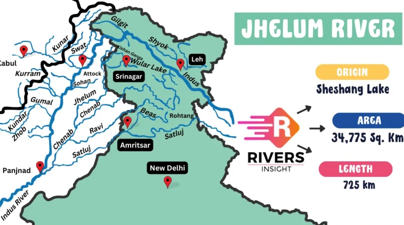
The Jhelum River originates from the Verinag Spring in Jammu and Kashmir, India. It flows approximately 725 kilometers through the Kashmir Valley into Pakistan, where it merges with the Chenab River. Historically known as the Vitasta in ancient Sanskrit texts, the river is mentioned in scriptures like the Rigveda and the Nilamata Purana.
| Source | Verinag Spring, Jammu & Kashmir |
| Length | 725 km |
| Basin Area | 55,213 sq. km. |
| Countries | India, Pakistan |
| Lakes | Wular Lake |
| Tributaries | Lidder, Sind, Pohru, Kishanganga |
| Hydropower Plants | Uri I & II, Kishanganga Plant |
| Confluence | Merges with the Chenab River |
| End Point | Trimmu, Punjab, Pakistan |
Table of Contents
Course of the Jhelum River
Jhelum River flows through both India and Pakistan, spanning three main sections: the Upper Course, Middle Course, and Lower Course.
1. Source and Upper Course
The Jhelum River originates at the Verinag Spring in the Kashmir Valley, India. It flows northwest through the valley, passing through Anantnag and Srinagar, before entering Wular Lake, one of India’s largest freshwater lakes.
- Source: Verinag Spring, Jammu and Kashmir, India
- Key Locations: Srinagar, Anantnag, Wular Lake
2. Middle Course
As the river moves out of the Kashmir Valley, it enters the Jhelum Gorge and flows through Baramulla, Uri, and Muzaffarabad in Pakistan-administered Kashmir.
- Key Locations: Baramulla, Uri, Muzaffarabad
- Geography: Jhelum Gorge
3. Lower Course
In its final stage, the Jhelum River flows south into Punjab, Pakistan, and merges with the Chenab River at Trimmu, contributing to the Indus River System.
- Key Locations: Trimmu, Punjab
Tributaries of the Jhelum River
The Jhelum River is fed by several important tributaries, which can be categorized into Left-Bank and Right-Bank tributaries.
Left-Bank Tributaries
- Lidder River
- Sind River
Right-Bank Tributaries
- Pohru River
- Kishanganga River (Neelum River)
Infrastructure & Power Generation
The Jhelum River supports several important dams and hydroelectric power plants.
Dams and Barrages:
- Mangla Dam
- Rasul Barrage
- Trimmu Barrage
- Uri Dam
Hydroelectric Power Plants:
- Uri I & II Power Stations
- Kishanganga Hydroelectric Plant
Historical Significance of the Jhelum River
- Ancient Period: Known as Vitasta in Hindu mythology, it is sacred and linked to the creation of the Kashmir Valley by Kashyapa Rishi.
- Medieval Period: The river was central to the rise and fall of dynasties like the Mughals and Dogras. Emperor Jahangir particularly appreciated its scenic beauty.
- Colonial Period: During the British era, the river’s strategic importance was recognized, especially in the context of the Great Game in Central Asia.


