Kabini River: Overview with Map
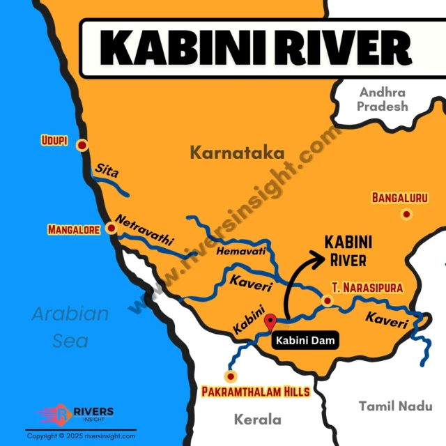
Kabini River is a major tributary of the Cauvery, flowing through the states of Kerala and Karnataka. It originates in Wayanad district, where the Panamaram and Mananthavady Rivers meet. Further, it has a length of about 240 km and drains a basin area of approximately 7,040 square kilometres.
Table of Contents
Origin and Course of Kabini River
Kabini River originates from the Pakramthalam Hills near the Kuttiady–Mananthavady road in Wayanad, Kerala. Flowing eastward, it passes through ecologically rich regions including the Wayanad Wildlife Sanctuary, Nagarhole National Park, and Bandipur National Park—all part of the Nilgiri Biosphere Reserve, a UNESCO World Heritage Site.
Along its course, it forms the scenic Kuruva Island before reaching the Kabini Reservoir near the Kerala–Karnataka border. It then flows into Karnataka and finally joins the Cauvery River at T. Narasipura.
Tributaries
The major tributaries of the Kabini River include:
- Panamaram River: The main tributary, joins Kabini near Payyampally.
- Makkiyad River: Merges with Kabini near Korome.
- Kalindi River: Originates from the Brahmagiri Hills, joins Kabini near the reservoir.
- Papanasini Stream: A small stream that joins the Kalindi River near Tirunelly Temple.
- Taraka River
Kabini Dam
- Location: Near Beechanahalli village in H.D. Kote taluk, Karnataka.
- Built On: Kabini River.
- Purpose: Irrigation and water supply.
- Capacity: Approx. 19.5 TMC.
- Significance: Supplies water to major cities including Mysuru and Bengaluru.