Mahanadi River System: Tributaries & Map of India
Mahanadi River, meaning “Great River,” is one of the most significant east-flowing rivers in India. It is the largest river in Odisha and the third-largest peninsular river after the Godavari and Krishna. Originating in Chhattisgarh, it flows through multiple states before emptying into the Bay of Bengal.
Table of Contents
Names of Mahanadi River in Different Eras
- Ancient Era – Kanak Nandini
- Dvapara Yuga – Chitrotpala (similar name found in Matsya Purana)
- Treta Yuga – Nilotpala (also mentioned in Vayu Purana)
- Mahabharata Era – Mahanad
- Kali Yuga – Mahashweta or Mahanadi
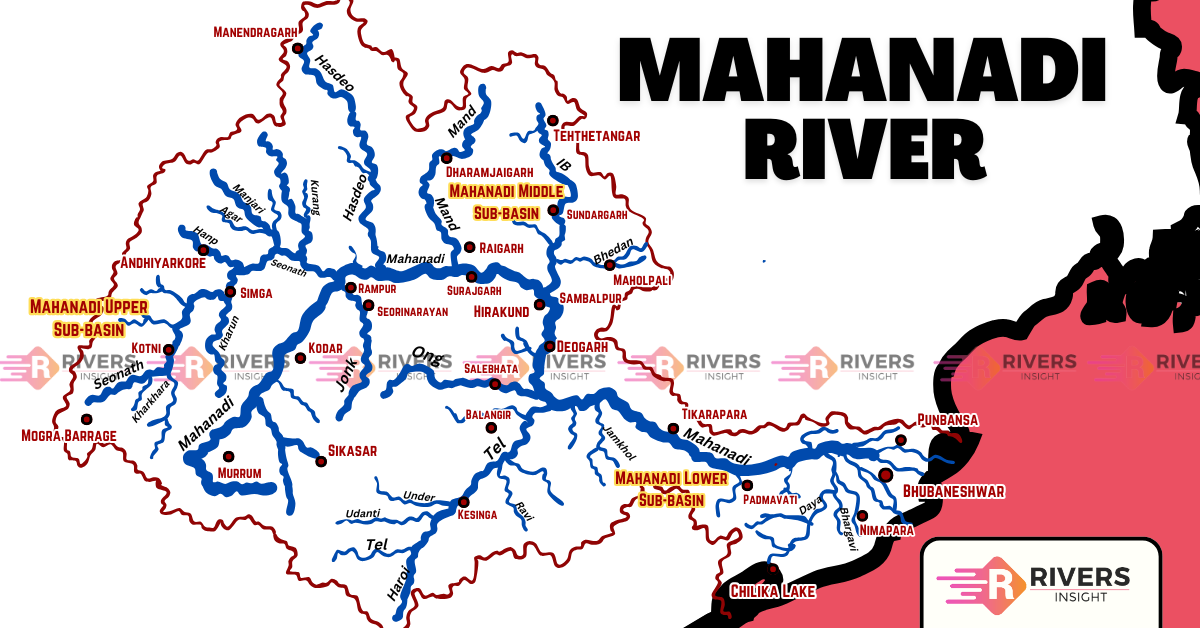
Origin and Course of Mahanadi River
The Mahanadi River originates from the Sihawa Hills in Dhamtari district, Chhattisgarh, at an elevation of 442 meters. It begins as a collection of small streams in the Dandakaranya foothills and initially flows northward for about 100 km before turning eastward into the plains.
The Mahanadi River flows through Chhattisgarh and Odisha, covering a total distance of 958 km before emptying into the Bay of Bengal. Its course is divided into three main sections:
1. Upper Course (Chhattisgarh Plateau)
- The river begins as a small stream in the Sihawa hills and flows northward for about 100 km.
- It passes through the Raipur and Mahasamund districts, grazing the eastern parts of Raipur Valley (elevation: 500-600 meters).
- After joining the Shivnath River, it turns eastward and continues its journey.
2. Middle Course (Odisha Plains)
- The river is joined by tributaries like Jonk and Hasdeo before entering Odisha.
- At Sambalpur, the river is dammed by the Hirakud Dam, the world’s longest earthen dam.
- The river moves eastward, passing through Baudh district and entering the Odisha plains near Nayagarh, about 14 km from Cuttack.
3. Lower Course (Delta Formation)
- Before reaching Cuttack, the river splits into distributaries, with Kathjori being the first major one.
- Kathjori further splits into channels like Kuakhai, Devi, and Surua, forming an extensive delta system.
- Finally, the river merges into the Bay of Bengal near Paradeep, Jagatsinghpur district.
- The Mahanadi-Brahmani Delta is among the largest in India, supporting agriculture and biodiversity.
States and Major Districts Covered
The Mahanadi River flows through two states:
- Chhattisgarh: Dhamtari, Raipur, Mahasamund, Bilaspur, Janjgir-Champa, and Raigarh.
- Odisha: Sambalpur, Jharsuguda, Bargarh, Cuttack, Angul, Nayagarh, Kendrapara, and Jagatsinghpur.
Drainage Basin of Mahanadi River
The Mahanadi River basin is the 8th largest river basin in India, covering a total catchment area of 1,39,681.51 sq. km, which accounts for 4.28% of the country’s total geographical area.
Geographical Boundaries
The Mahanadi basin is physically enclosed by:
- Central India Hills in the north
- Eastern Ghats in the south and east
- Maikala Hill Range in the west
The basin is roughly circular in shape, with a maximum length of 587 km and a width of 400 km.
States Covered by the Mahanadi Basin
The basin extends across multiple states, with the largest portions in Chhattisgarh and Odisha, followed by smaller areas in Maharashtra, Madhya Pradesh, and Jharkhand. The distribution is as follows:
- Chhattisgarh – 52.42%
- Odisha – 47.14%
- Maharashtra – 0.23%
- Madhya Pradesh – 0.11%
- Jharkhand – 0.1%
Tributaries of the Mahanadi River
Mahanadi River has an extensive network of tributaries that significantly contribute to its flow and catchment area. The total length of the river from its origin to the Bay of Bengal is approximately 958 km, and its tributaries cover nearly 46.63% of its total catchment area.
The drainage system of Mahanadi is more extensive on the left bank than on the right, particularly in the upstream region of the Hirakud Reservoir. The Seonath River, the longest tributary, drains nearly 25% of the Mahanadi basin.
Left Bank Tributaries
The left bank tributaries, primarily originating from the northern and western hills, play a crucial role in maintaining the river’s flow.
- Seonath River – As the largest tributary, it originates from Panabaras Hill (625 m) in Rajnandgaon, Chhattisgarh, and drains an area of 30,761 sq. km. This river is a major water source for the region.
- Hasdeo River – Originating in Chhattisgarh, this river flows through Bilaspur and Korba districts before merging with the Mahanadi. It supports irrigation and sustains local communities.
- Mand River – Covering a length of 260 km, this river meets the Mahanadi near Chandarpur, further enhancing its water flow.
- Ib River – Rising in Raigarh district (Chhattisgarh), it drains an area of 12,447 sq. km, stretching into Odisha before joining the Mahanadi.
Right Bank Tributaries
On the other hand, the right bank tributaries, originating from the southern plateaus and hills, also contribute significantly to the river system.
- Ong River – Originating in the Eastern Ghats, this river flows entirely through Odisha. It plays a key role in agriculture and irrigation.
- Tel River – This is the largest right-bank tributary, originating in the Kalahandi district of Odisha and meeting the Mahanadi near Sonepur. It drains a vast area of 22,818 sq. km, making it an important contributor to the river system.
- Jonk River – This river originates in the Khariar Plateau (Odisha) and passes through Chhattisgarh before merging with the Mahanadi, further enriching its flow.
Moreover, several small streams between the Mahanadi and Rushikulya rivers drain directly into Chilika Lake, forming an essential part of the basin’s hydrology. These tributaries together make the Mahanadi one of the most significant and resourceful river systems in eastern peninsular India.
Major Dams
- Hirakud Dam (Odisha)
- Gangrel Dam (Chhattisgarh)
- Tandula Dam (Chhattisgarh)
- Kalma Barrage (Odisha)
- Sondur Dam (Chhattisgarh)
- Hasdeo Bango Dam (Chhattisgarh)
Industries and Economic Importance
The Mahanadi River basin is rich in minerals and water resources, making it a key industrial region. Major cities like Raipur, Durg, and Cuttack serve as important commercial hubs.
Key Industries:
- Iron and Steel: Bhilai Steel Plant.
- Aluminum: Factories at Hirakud and Korba.
- Paper: Mill near Cuttack.
- Cement: Plant in Sundargarh.
- Mining: Coal, iron, and manganese extraction.
- Agriculture-Based: Sugar and textile mills.
Conclusion
The Mahanadi is not just a river but a lifeline for agriculture, industry, and livelihoods. Sustainable management is key to preserving its resources.
That’s all about the Mahanadi River! Share your thoughts in the comments!