Mahi River: Complete Overview of Origin & Tributary Map
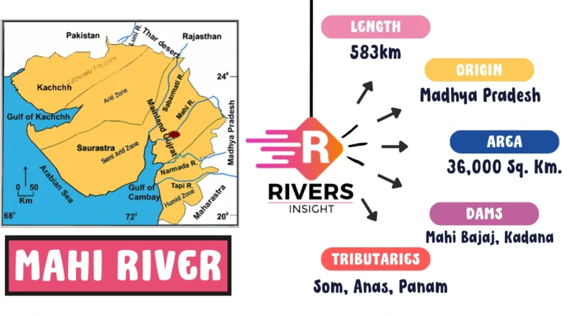
Welcome to an exploration of the Mahi River, a significant waterway in western India. Situated in the states of Gujarat and Rajasthan, the river begins its journey in the Vindhya Range near Bhopawar village in Madhya Pradesh. Flowing for about 583 km, it eventually meets the Arabian Sea. Covering an extensive basin of 36,000 square kilometers, the Mahi River plays a vital role in providing water for irrigation, drinking, and industrial use in the region.
In this article, we take a closer look at the Mahi River, offering valuable information on its map, origin, tributaries, and dams.
| River | Mahi |
| Lenght | 583 km |
| Origin | Kanta Hills |
| States | Gujarat and Rajasthan |
| Tributaries | Som, Anas, and Panam |
Table of Contents
Key Features of the Mahi River System
- Origin and Length: Mahi River originates in the Kanta Hills of the Vindhya Range and flows 583 km to the Arabian Sea.
- River Basin: Spans 36,000 sq km across Gujarat and Rajasthan.
- Districts Covered: Passes through districts in Gujarat and Rajasthan, including Panchmahal, Vadodara, Kheda, Anand, Mahisagar, Dungarpur, and Banswara.
- Tributaries: Fed by tributaries like Som, Anas, and Panam Rivers.
- Seasonal Flow: Intermittent flow peaks during the monsoon season (June to September).
- Key Dams: Mahi Bajaj Sagar Dam, Kadana Dam, and Panam Dam are crucial for water management.
- Geological Features: Rocky stretches, rapids, waterfalls, canyons, and gorges define the river’s course.
- Biodiversity: Supports diverse flora and fauna, including endangered species like the Indian Skimmer and Gharial.
Origin of Mahi River
The Mahi River originates from the Vindhyas near Bhopawar village in the Sardarpur tehsil of the Dhar district in Madhya Pradesh, India. From this point, the river flows in a southwest direction before ultimately reaching its destination at the Gulf of Khambhat.
Tributaries of the Mahi River
The following are the left and right bank tributaries of the Mahi River:
Left Bank Tributaries
- Panam River: Originating in the Aravalli Range near Himmatnagar, Gujarat, the Panam River covers approximately 94 kilometers before merging with the Mahi near Lunawada, Gujarat.
- Anas River: Another left-bank tributary, the Anas River, has its source in the Aravalli Range near Idar, Gujarat. It flows around 240 kilometers before converging with the Mahi River near Kheda, Gujarat.
Right Bank Tributaries
- Meshwo River: Emerging from the hills near Dharampur, Gujarat, the Meshwo River flows about 100 kilometers before meeting the Mahi River near Godhra, Gujarat.
- Orsang River: A major right-bank tributary, the Orsang River, originates in the Satpura Range near Khandwa, Madhya Pradesh. It travels for about 450 kilometers, eventually joining the River Mahi near Tilakwada, Gujarat.
Dams on the Mahi River
The Mahi River hosts several dams designed for purposes such as irrigation, hydroelectricity generation, and more. Here is a list of major dams along the Mahi River:
1. Mahi Bajaj Sagar Dam:
- Location: Panchmahal district, Gujarat
- Year Built: 1961
- Purpose: Irrigation for approximately 70,000 hectares of land
- Hydroelectric Capacity: 240 MW
2. Kadana Dam:
- Location: Sabarkantha district, Gujarat
- Year Built: 1979
- Storage Capacity: 308.22 million cubic meters
- Purpose: Irrigation for about 28,000 hectares of land
3. Wanakbori Dam:
- Location: Kheda district, Gujarat
- Year Built: 1979
- Storage Capacity: 920 million cubic meters
- Purpose: Irrigation for approximately 22,000 hectares of land
- Hydroelectric Capacity: 1,470 MW
4. Panam Dam:
- Location: Dahod district, Gujarat
- Year Built: 1983
- Storage Capacity: 88.77 million cubic meters
- Purpose: Irrigation for about 3,500 hectares of land
5. Mahi Canal Head Regulator:
- Location: Vadodara district, Gujarat
- Year Built: 1970
- Purpose: Provides irrigation for about 18,000 hectares of land.
These dams collectively contribute to the efficient utilization of water resources along the river, playing a crucial role in agricultural development, power generation, and overall regional prosperity.
Conclusion
In conclusion, the Mahi River, with its meandering course and diverse landscapes, weaves through the heart of western India, contributing to the region’s beauty and vitality. As it journeys from its source to the Arabian Sea, the river becomes a silent witness to the surrounding districts, creating a natural tapestry that shapes the essence of the land it traverses.
More related articles: