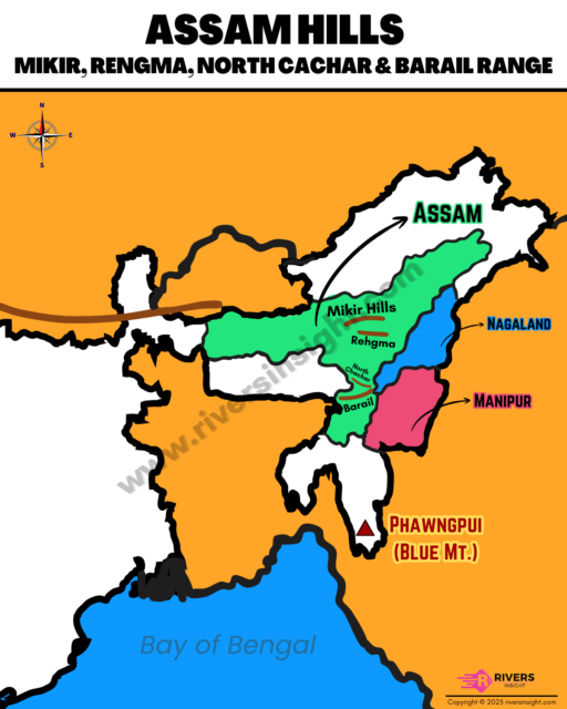
Mikir, Rengma, North Cachar Hills & Barail Range of Assam [Map]
Advertisements
Mikir, Rengma, North Cachar, and Barail Hills form the transitional hill system of Assam in Northeast India, lying between the Meghalaya Plateau in the west and the Naga Hills in the east. These isolated hill ranges are considered part of the Purvanchal Range, acting as a natural link between the Eastern Himalayas and the Barak–Brahmaputra Valley.
Table of Contents
1. Mikir Hills
- Mikir Hills is also known as the Karbi Plateau.
- It form an isolated hill system in central Assam, lying south of Kaziranga National Park.
- These hills cover an area of around 7,000 sq. km, mainly within the Karbi Anglong district.
- They are bordered by:
- Brahmaputra Valley – to the north
- Dhansiri Valley – to the east
- Kopili Valley – to the west
- Jamuna Valley – to the south
- Elevations ranging between 300 and 1,200 meters.
- Dambuchung Peak is one of the highest points in the region.
- The region is drained by tributaries of the Dhansiri and Kopili Rivers.
2. Rengma Hills
- Rengma Hills are located in the present-day Karbi Anglong district of Assam, forming a part of the larger Karbi-Meghalaya Plateau.
- They lie east of the main Mikir Hills area, connecting Assam’s hill systems with Nagaland’s Naga Hills.
- The region is named after the Rengma Naga tribe.
- Highest peak in this hill range is Chenghehishong.
3. North Cachar (Dima Hasao) Hills
- It is a part of Barail Range.
- Located in southern Assam, linking the Meghalaya Plateau in the west and the Naga Hills in the east.
- Acts as a natural bridge between the Brahmaputra and Barak Valleys.
- Inhabited by Dimasa, Zeme Naga, and Hmar tribes.
- Rivers like Diyung, Jatinga, and Mahur flow southward to join the Barak River.
- Famous for the Jatinga Bird Mystery, where birds descend unnaturally at night.
4. Barail Range
- The Barail Range forms the highest hill range in Assam, extending from the Naga Hills in the east to the North Cachar Hills in the west.
- Highest point is Thumjang Peak.
- Acts as a watershed between the Brahmaputra and Barak River systems.
- Average elevation ranges between 1,000 to 1,500 metres.
- Major rivers like the Jiri, Jatinga, and Sonai originate here.
- Barail Wildlife Sanctuary near Silchar.