Netravati River: On the Map of Karnataka
Introduction
Netravati River is also known as Netravathi Nadi and is a major west-flowing river in Karnataka India. It stretches approximately 103 km from its origin in the Western Ghats to its confluence with the Arabian Sea near Mangalore. Often referred to as the lifeline of Dakshina Kannada, the river is essential for the region’s sustainability.
Table of Contents
Geographical Features of Netravati River
Origin and Course
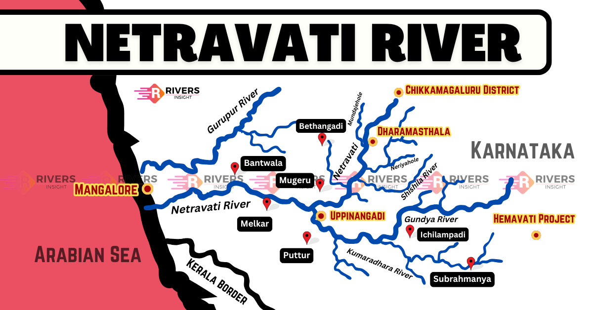
Netravati River originates in the Bangrabalige Valley of Yelaneeru Ghat in the Kudremukha range of the Western Ghats. Beginning its journey from an elevation of about 1,300 meters in Chikkamagaluru district, Karnataka.
As it moves forward, the Netravati merges with its major tributary, the Kumaradhara River, at Uppinangadi. The Kumaradhara originates near Bisle Ghat and is formed by the confluence of Giri Hole and Adda Hole. In addition to Kumaradhara, several other tributaries contribute to its flow, including:
- Kumaradhara River – Joins Netravati at Uppinangadi
- Mrithyunjaya River – Flows from the Charmadi range
- Kapila River – Originates in the Shishila region
- Aniyoor River – Contributes to the river’s flow
- Somavathi River – Joins Netravati in its mid-course
Furthermore, as the river continues its course, it passes through Dharmasthala, a renowned pilgrimage site. It also serves as the primary water source for Bantwal and Mangalore.
Finally, after completing its course, the Netravati reaches Mangalore and drains into the Arabian Sea.
Tributaries
- Kumaradhara River
- Mrithyunjaya River (Charmadi Hole)
- Kapila River (Shishila River)
- Aniyoor River
- Somavathi River (Laila River)
- Kaniyoor River
- Gundya River (Kempu Hole)
Basin and Catchment Area
- Catchment Area: Around 3,300 sq. km, receiving an annual rainfall of 5000 mm.
- Key Locations: Dharmasthala, Uppinangadi, Bantwal, Thumbe, Mangalore.
- Major Tributaries in the Basin: Yettinaholé, Kempholé, Gundia River.
- Biodiversity: Part of the Western Ghats hotspot, home to 4,000+ species, including endangered flora and fauna.
Water Flow and Rainfall
- The Netravati River receives most of its rainfall during the southwest monsoon, which lasts four to five months.
- From June to September, the region gets an average rainfall of about 3,450 mm.
- The remaining eight months receive only 550 mm of rainfall on average.
Seasonal Variations in Water Flow:
- During the monsoon season, the river experiences heavy flooding.
- In summer, the river has a lean flow, mainly sustained by percolated water from the Western Ghats.
Important Places Along the Netravati River
- Mangalore City – A coastal destination known for its temples, beaches, and historical sites. Popular attractions include Kudroli Gokarnath Temple, St. Aloysius Chapel, and Tannirbavi Beach.
- Dharmasthala – A major pilgrimage site 70 km from Mangalore, home to the Dharmasthala Manjunatheshwara Temple, dedicated to Lord Shiva.
- Udupi – Located 60 km north of Mangalore, this city is famous for the Sri Krishna Temple and its scenic beaches.
- Kukke Subramanya Temple – A significant temple dedicated to Lord Subramanya, situated around 105 km from Mangalore.
Netravati River Diversion Project
The Karnataka Government plans to divert the headwaters of the Yettinahole River, a tributary of the Kumaradhara, which in turn is a tributary of the Netravati River. Further, the project aims to transfer water from the Western Ghats to the eastern plains of Karnataka.