Noyyal River of Tamil Nadu with Map
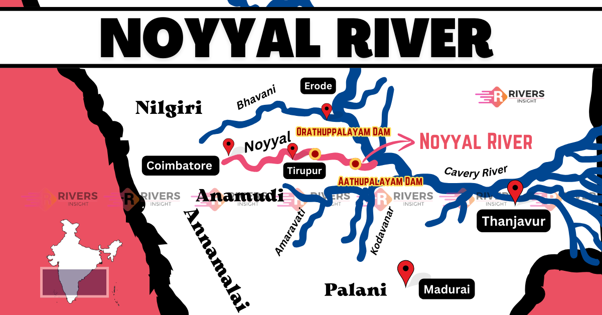
Noyyal River is an important tributary of the Cauvery River, flowing through Western Tamil Nadu. It originates from the Vellingiri Hills in the Western Ghats and travels through the districts of Coimbatore, Tiruppur, and Erode before merging with the Cauvery. Spanning 180 km in length and 25 km in width, the Noyyal River Basin has long supported agriculture with its extensive network of irrigation tanks.
Table of Contents
Origin and Course of Noyyal River
Noyyal River originates from the Vellingiri Hills, which are part of the Nilgiri Biosphere Reserve, near Coimbatore at an altitude of 600 meters above sea level. From its source, the river flows for 173 km, passing through the districts of Coimbatore, Tiruppur, Karur, and Erode, before merging with the Cauvery River at Noyyal village in Karur district.
Course of the River
- Western Ghats (Vellingiri Hills): The river begins its journey in the hills, which are known for their rich biodiversity and ecological significance.
- Coimbatore and Tiruppur districts: Flowing through these regions, the river has historically supported agriculture and industries, while also being notable for archaeological sites from the Chalukya and Chola periods.
- Erode district: As it moves further east, the river feeds traditional irrigation tanks, which have been used for water conservation for centuries.
- Karur district (Confluence with the Cauvery): The river completes its journey by merging with the Cauvery River at Noyyal village.
Tributaries
The Noyyal River has two main tributaries:
- Cheyyar River (Chadiaar River): Originates in the Western Ghats and flows through Chaadivayal before merging with the Noyyal River at Kooduthurai.
- Kanchimanadhi River: Also originates in the Western Ghats and contributes to the Noyyal’s flow.
Dams and Reservoirs
The Noyyal River has two major dams:
- Orathuppalayam Dam (near Chennimalai)
- Aathupalayam Dam (near Vellakoil)
These dams were built to irrigate approximately 20,000 acres of land in Tirupur and Karur districts. However, the Orathuppalayam Dam is no longer in use for irrigation and currently acts as an effluent storage tank for textile industries in Tirupur.
In addition to these dams, the river has 23 check dams that help in water conservation and irrigation.
Drainage Basin
The Noyyal River Basin covers approximately 3,500 square kilometers, spanning the districts of Coimbatore, Tiruppur, Erode, and Karur in Western Tamil Nadu. It extends 180 km in length and 25 km in width, forming part of the Cauvery River system.
History
The Noyyal River holds great significance in Tamil history and was originally known as Kanchimanadi, as mentioned in the Perur Puranam. However, in 1750 A.D., its name was changed to Noyyal, after the village where it merges with the Cauvery River.
At the confluence of the Noyyal and Cauvery Rivers, there is a village called Noyyal. This place is considered sacred, and an ancient temple dedicated to Goddess Sellandiyamman is located there.