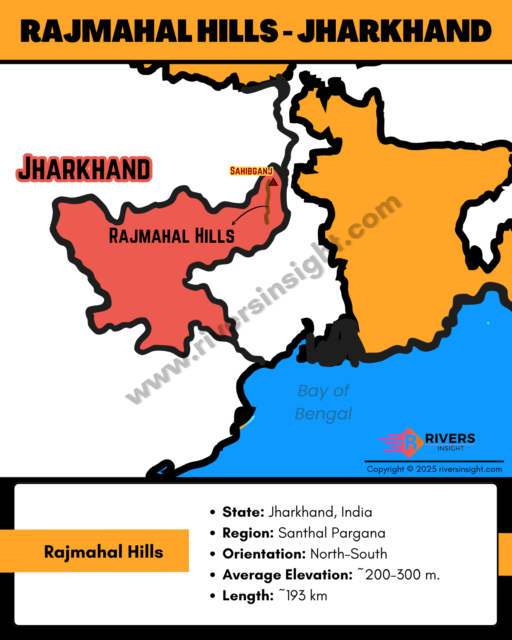
Rajmahal Hills: Map & Location in Jharkhand, India
Advertisements
Rajmahal Hills are a volcanic hill range in the Santhal Pargana region of Jharkhand in India, known for their basaltic formations called the Rajmahal Traps. They are named after the historic town of Rajmahal and hold great geological and paleo-botanical significance.
Table of Contents
Location of Rajmahal Hills
- State: Jharkhand, India
- Region: Santhal Pargana
- Districts Covered: Sahibganj, Pakur, Godda, parts of Dumka
- Orientation: North–South
- Average Elevation: ~200–300 m.
- Length: ~193 km
- Width: ~48 km at the centre & 20–25 km at the northern & southern ends
- Nearby Towns: Rajmahal, Sahibganj, Pakur
Boundaries
- North & East: Ganga River
- West & South: Undulating plains of Godda and Dumka
Geological Origin & Formation
- Formed by Jurassic–Cretaceous volcanic eruptions (~117 million years ago)
- Part of the Rajmahal Traps — thick basaltic lava flows
- Associated with the Kerguelen hotspot during the breakup of Gondwana
- Contains important intertrappean fossil beds with early plant fossils
Rivers & Drainage
Important rivers around the Rajmahal Hills include:
- Ganga River (major boundary)
- Gumani River
- Bansloi River
Communities & PVTGs in the Region
Some PVTGs (Particularly Vulnerable Tribal Groups) present in the broader Jharkhand–Bihar region include:
- Asur
- Birhor
- Birjia
- Hill Kharia
- Korwa
- Mal Paharia
- Parhaiya
- Sauria Paharia
- Savara