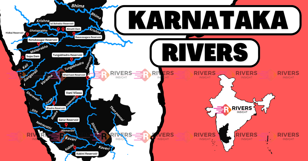
Rivers of Karnataka with Map: East & West Flowing
Karnataka is a state in the southwestern region of India, bordered by Maharashtra to the north, Goa to the west, Kerala to the southwest, Tamil Nadu to the southeast, and Andhra Pradesh to the east. Its capital, Bengaluru (formerly Bangalore), is a major hub for technology and innovation, often called the “Silicon Valley of India.“
Further, the state is home to the Western Ghats, a UNESCO World Heritage site, and has an intricate network of rivers, including the Cauvery, Krishna, and Tungabhadra. There are around 20 major rivers and over 60 minor rivers in Karnataka, making it one of the most river‑rich states in the country.
Table of Contents
East-Flowing and West-Flowing Rivers of Karnataka
East-Flowing Rivers of Karnataka
- Kaveri (Cauvery) River
- Krishna River
- Tungabhadra River
- Ghataprabha River
- Malaprabha River
- Bhima River
- Hemavati River
- Kabini River
- Arkavati River
- Suvarnavathi (Honnuhole) River
- Lokapavani River
- Noyyal River
- Amaravati River
- North Pennar River
- South Pennar River
- Palar River
West-Flowing Rivers of Karnataka
- Sharavathi River
- Mandavi River
- Kalinadi River
- Gangavalli River
- Aghanashini River
- Chakra Nadi
- Sita and Kali River
- Varahi River
- Netravathi River
- Barapole River
Visit: If you want to read detailed article on East and West Flowing Rivers of India.
Map of Rivers in Karnataka
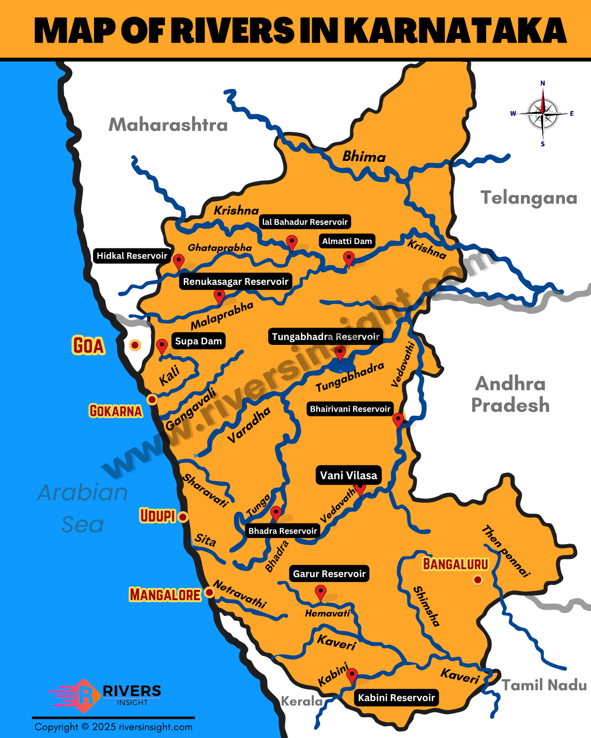
Major Rivers of Karnataka
1. Cauvery (Kaveri) River
- Origin: Talakaveri, Kodagu district, Western Ghats, Karnataka.
- Length: ~800 km (320 km in Karnataka).
- Course: Flows through Karnataka and Tamil Nadu, draining into the Bay of Bengal.
- Tributaries: Hemavati, Kabini, Bhavani (Left); Lakshmana Tirtha, Arkavathy, Noyyal (Right).
- Known as: The “Ganga of the South.”
- Major dams: Krishna Raja Sagara (KRS) Dam, Kabini Dam.
- Important cities: Mysuru, Srirangapatna.
- Dispute: Cauvery water sharing between Karnataka and Tamil Nadu.
2. Tungabhadra River
- Origin: Confluence of Tunga and Bhadra rivers at Koodli, Shivamogga district.
- Length: 531 km.
- Course: Flows through Karnataka and Andhra Pradesh, joining the Krishna River.
- Tributaries: Varada (Left); Handri, Vedavathi (Right).
- Major dam: Tungabhadra Dam near Hospet.
- Notable sites: Flows through the UNESCO World Heritage site Hampi.
3. Krishna River
- Origin: Mahabaleshwar, Maharashtra.
- Length: 1,400 km (480 km in Karnataka).
- Course: Flows through Maharashtra, Karnataka, Telangana, and Andhra Pradesh, and empties into the Bay of Bengal.
- Tributaries: Ghataprabha, Malaprabha, Bhima, Tungabhadra.
- Major dams: Almatti Dam, Narayanpur Dam.
- Important cities: Bagalkot, Raichur.
4. Sharavathi River
- Origin: Ambuthirtha, Shivamogga district, Western Ghats.
- Length: 128 km.
- Course: Flows westward into the Arabian Sea.
- Famous for: Jog Falls, one of India’s tallest waterfalls.
5. Hemavati River
- Origin: Western Ghats, near Ballala Rayana Durga, Chikkamagaluru district.
- Length: 245 km.
- Course: Flows southeast and merges with the Cauvery River.
- Tributaries: Yagachi River.
- Major dam: Hemavati Dam (Gorur Dam).
6. Kabini River
- Origin: Wayanad district, Kerala (enters Karnataka).
- Length: 240 km.
- Course: Flows through Karnataka and joins the Cauvery River.
- Tributaries: Taraka, Nugu.
- Famous for: Kabini Wildlife Sanctuary, home to a large elephant population.
7. Netravati River
- Origin: Kudremukh range, Chikkamagaluru district, Western Ghats.
- Length: 103 km.
- Course: Flows westward, passing through Mangaluru, into the Arabian Sea.
8. Malaprabha River
- Origin: Kanakumbi, Belagavi district, Western Ghats.
- Length: 304 km.
- Course: Flows eastward and joins the Krishna River.
- Major dam: Naviluteertha Dam.
9. Ghataprabha River
- Origin: Jamboti Hills, Belagavi district, Western Ghats.
- Length: 283 km.
- Course: Flows eastward, joining the Krishna River.
- Major dam: Hidkal Dam.
- Attractions: Known for Gokak Falls, a popular tourist attraction.
10. Bhima River
- Origin: Bhimashankar, Maharashtra.
- Length: 861 km (275 km in Karnataka).
- Course: Flows through Maharashtra, Karnataka, and Telangana, joining the Krishna River.
- Tributaries: Kumudvathi, Ghod.
Largest and Smallest River of Karnataka
The Krishna River is Karnataka’s largest river, flowing for about 480 kilometers within the state. It provides crucial water for irrigation and power, with major dams like Almatti Dam along its course.
The Netravati River is the smallest in Karnataka, at just 103 kilometers long. It flows through Mangaluru and drains into the Arabian Sea, supplying vital water to the coastal areas.
Drainage Basin
The drainage area of rivers in Karnataka plays a crucial role in the state’s water management and hydrology. The east-flowing rivers account for 166.25 sq.km., which is about 12.73% of the total drainage area. These rivers, which flow towards the Bay of Bengal, are important for irrigation and drinking water.
In contrast, the west-flowing rivers cover a significantly larger area of 24.25 sq.km., constituting 87.27% of the total drainage area. These rivers drain into the Arabian Sea and are vital for both ecological balance and the state’s water supply.
Overall, the total drainage area for all rivers in Karnataka is 190.5 sq.km., with the majority of the state’s river systems flowing westward.
We hope you found this information about the rivers of Karnataka insightful! Feel free to share your thoughts, comments, or any feedback below. We’d love to hear from you!