Chambal River of India: Map & Origin
The Chambal River is a major river in India that flows through the states of Madhya Pradesh, Rajasthan, and Uttar Pradesh. It is a major tributary of the Yamuna River that eventually flows into the Bay of Bengal. The river flows from Madhya Pradesh’s Vindhya mountain range and covers approximately 1024 kilometers before merging with the Yamuna River.
In this article, we will cover all important aspects of the Chambal River. We will discuss its origin, the states it flows through, and its length including Map. Further, we will also look at its major tributaries, the dams built on it, and where it drains. A map will be included to show the river’s route and its significance to the regions it touches.
| River | Chambal |
| Origin | Sringar Chouri peak |
| Length | 1024 km |
| Ending Point | Mandav |
| Famous for | National Chambal Sanctuary |
Table of Contents
Geographical Features of Chambal River
Here are some key geographical characteristics of the Chambal River:
- Location: Flows through Madhya Pradesh, Rajasthan, and Uttar Pradesh.
- Boundary: Forms part of the boundary between Rajasthan and Madhya Pradesh.
- Length: Stretches 1024 kilometers.
- Origin: Begins at Sringar Chouri peak in the Vindhya Range, Madhya Pradesh.
- Emergence Point: Near Mandav, 67.5 km from Mhow in Indore district.
- Significance in Rajasthan: The largest river in the state, crucial for economy and ecology.
- Confluence: Joins the Yamuna River in Etawah district, Uttar Pradesh, and eventually flows into the Ganges River.
- Drainage: Drains the Malwa region of northern Madhya Pradesh; Banas River drains southeastern Rajasthan.
- Notable Landmark: Pachnada confluence in Uttar Pradesh, where it meets the Kwari, Yamuna, Sind, and Pahuj rivers.
- Tributaries: Left bank – Banas and Mej Rivers; Right bank – Parbati, Kali Sindh, and Shipra Rivers.
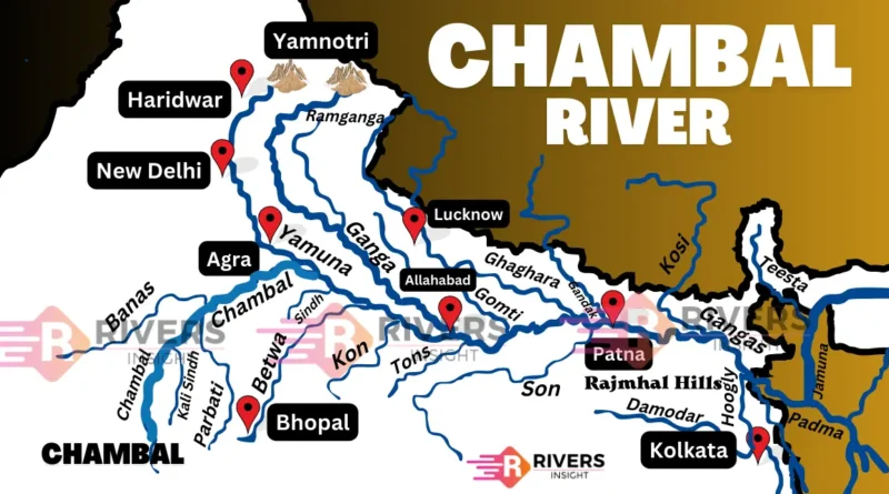
Chambal River in India Map

Origin and Course
Chambal River begins in Madhya Pradesh, a central state in India. It starts at Sringar Chouri peak, on the northern side of the Vindhya Range, near the town of Mandav, about 67.5 kilometers from Mhow in the Indore district.
The Chambal River begins in Madhya Pradesh and flows northward, marking part of the border between Madhya Pradesh and Rajasthan. Afterward, the river turns northwest, crossing the dry lands of Rajasthan. Here, it becomes vital, to support agriculture and preserve the environment. In Rajasthan, it’s the biggest river, essential for the local economy and ecological balance.
The Chambal River continues its journey, re-entering Madhya Pradesh and flowing northeast into Uttar Pradesh. One remarkable aspect of the river is the Pachnada confluence near Bhareh in Uttar Pradesh, where it joins with the Kwari, Yamuna, Sind, and Pahuj rivers. This meeting point holds great cultural and religious importance for the local communities.
The Chambal River joins the Yamuna River in the Etawah district of Uttar Pradesh. Eventually, the combined waters of the Yamuna and Chambal join the Ganges River, which flows onward to the Bay of Bengal.
Important Places Along the Chambal River
- Mandav, Madhya Pradesh: Near the origin of the river.
- Mhow, Madhya Pradesh: Close to the source, an important military town.
- Kota, Rajasthan: A major city on the banks of the Chambal, known for its educational institutions and historical significance.
- National Chambal Sanctuary, Uttar Pradesh: A protected area for critically endangered species like the Gharial and the Gangetic Dolphin.
- National Chambal Gharial Wildlife Sanctuary, Madhya Pradesh: A sanctuary focused on conserving the critically endangered Gharial crocodile.
- Dholpur, Rajasthan: A historic city with the famous Machkund Temple.
- Pachnada, Uttar Pradesh: Confluence point with the Kwari, Yamuna, Sind, and Pahuj rivers.
- Etawah, Uttar Pradesh: Where the Chambal merges with the Yamuna River.
Dams on the Chambal River
- Gandhi Sagar Dam: A masonry dam located in Madhya Pradesh, it is the first in the Chambal Valley Project. It serves purposes like hydroelectric power generation and irrigation.
- Rana Pratap Sagar Dam: Situated in Rajasthan, this dam is primarily used for hydroelectric power and irrigation. It lies downstream of the Gandhi Sagar Dam.
- Jawahar Sagar Dam: Located further downstream in Rajasthan, this dam aids in hydroelectric production and irrigation, forming a critical part of the Chambal Valley Project.
- Kota Barrage: Positioned downstream of Jawahar Sagar, this barrage regulates water flow for irrigation, benefiting agricultural lands in Rajasthan.
Tributaries of Chambal
Left Bank Tributaries:
- Banas River: Largest left-bank tributary, originating from the Aravalli Range.
- Mej River: Flows from the Mewar region.
Right Bank Tributaries:
- Parbati River: Originates in the Malwa region of Madhya Pradesh, and flows through the Mandsaur and Jhalawar districts in Rajasthan, merging near Kota Barrage.
- Kali Sindh River: Emerges from the Vindhya Range, courses through Shivpuri and Guna districts in Madhya Pradesh, and joins near Bhind in Madhya Pradesh.
- Shipra River: Shipra River begins in the Vindhya Range, travels through Indore and Ujjain districts in Madhya Pradesh, and converges near Ghinoda village in Rajasthan.
National Chambal Sanctuary
- Established in 1979, it covers 5400 square kilometers across Rajasthan, Madhya Pradesh, and Uttar Pradesh.
- Known for protecting the critically endangered Gharial crocodile, along with other crocodile species, turtles, and diverse fish.
- A hotspot for birdwatching with over 300 bird species, including the endangered Indian Skimmer.
- The Chambal River has cultural and historical importance with ancient temples and ruins.
- Supports local communities through fishing, agriculture, and tourism.
- Offers activities like river safaris, nature walks, and birdwatching tours for visitors.
The National Chambal Sanctuary serves as a vital refuge for wildlife and a source of livelihood for local communities, embodying the harmony between conservation and sustainable living.