Gomti River: Origin, Map, Length, Tributaries & Dams
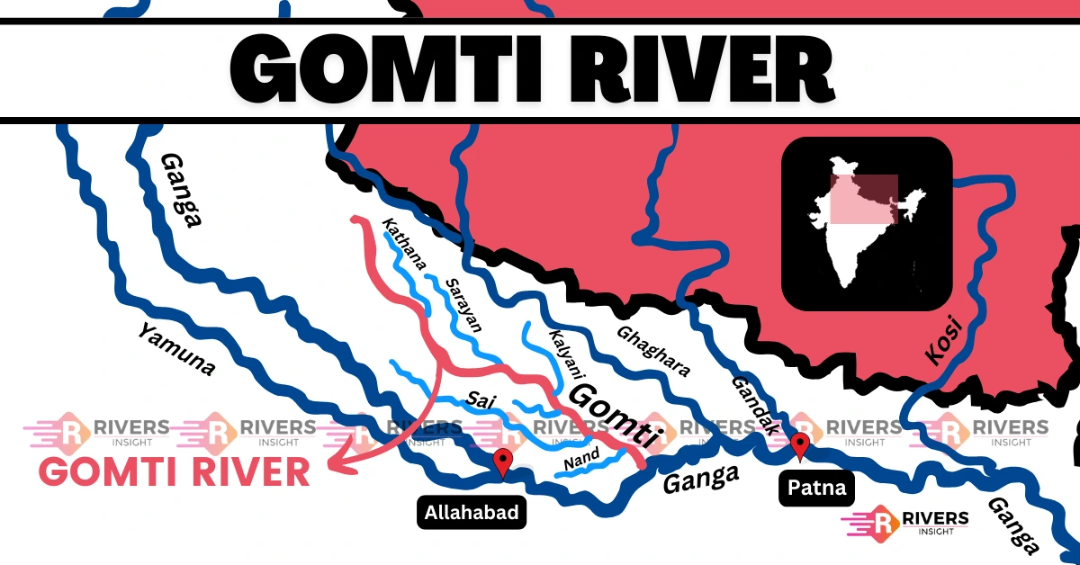
Gomti River is a major perennial river flowing entirely through Uttar Pradesh, with a total length of about 940 km. It originates from Gomath Tal in Pilibhit district, close to the Pilibhit Tiger Reserve and travels across the state before meeting the Ganga River near Kaithi in Ghazipur district.
| Length | 940 km |
| Starting Point | Gomath Tal |
| End point | Kaithi, Ghazipur district |
| State | Entirely in Uttar Pradesh |
| Type | Perennial river |
Table of Contents
Origin and Course of Gomti River
Gomti River originates from Gomath Tal (Fulhar Jheel) near the town of Madho Tanda in Pilibhit district which lies within the Pilibhit Tiger Reserve. From here, the river travels a distance of about 940 kilometers entirely in Uttar Pradesh before it merges with the Ganga River near Saidpur/Kaithi in Ghazipur district.
It flows through the following districts:
- Pilibhit
- Shahjahanpur
- Hardoi
- Sitapur
- Lucknow
- Barabanki
- Sultanpur
- Jaunpur
- Ghazipur
Markandey Mahadev Temple, located near the confluence, is an important pilgrimage site.
Map of Gomti River
Tributaries
Gomti River has 23 tributaries, but the Sai River is the largest and most influential tributary. Some tributaries are:
- Gaichi River
- Sukheta
- Chuha
- Kathana
- Sarayan
- Sai River
- Kukrail Nala
- Behta Nala
Drainage Basin
- Total Basin Area: Over 30,000 km²
- Region: Ghaghara–Ganga Interfluve (Doab)
- Located within the central part of the Ganga Plains
- Basin direction: Northwest to Southeast, parallel to the Himalayan foothills
For more rivers in the state, see our detailed guide on Rivers of Uttar Pradesh.
Dams and Barrages on Gomti River
Gomti is not a Himalayan snow-fed river, so no major dams exist on it. However, there are important barrages, and check dams have been constructed for water regulation and flood control:
- Gomti Barrage (Lucknow): Maintains water level in the city and supports flow regulation.
- Gaughat Waterworks (Lucknow): Major intake point for drinking-water supply.
- Small Check Dams (Upper & Central Basin): Built across Pilibhit, Shahjahanpur and Lakhimpur Kheri for groundwater recharge and local irrigation.
Major Bridges
- Pucca Pul (Hardinge Bridge)
- Hanuman Setu Bridge
- Kudiya Ghat Bridge (near which is the old Iron Bridge)
- Nishatganj Bridge
Gomti River is regarded as the daughter of Rishi Vashishtha in Hindu belief, and a holy dip—especially on Ekadashi—is considered spiritually purifying. The river is also associated with the Gomti Chakra, a small circular shell believed to bring protection and good fortune, often kept as a sacred charm.