Alaknanda River: Map & Origin with Key Facts
Advertisements
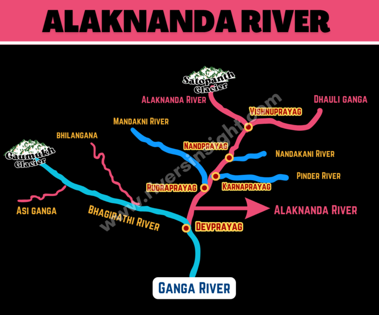
The Alaknanda River is a major source stream of the Ganga, flowing through the Garhwal Himalayas in Uttarakhand. It originates from the Satopanth and Bhagirath Kharak glaciers near Mana village, close to the India–Tibet border. Soon after, it joins the Saraswati River and forms the Panch Prayag. Finally, at Devprayag, it joins the Bhagirathi River, forming the Ganga River.
- Origin: Satopanth and Bhagirath Kharak Glaciers in the Garhwal Himalayas, Uttarakhand
- Length: 190 km
- State Covered: Uttarakhand
- Confluence: Joins the Bhagirathi River at Devprayag to form the Ganga River
- Drainage Basin: Approx. 10,800 sq. km.
Major Tributaries
- Dhauliganga River
- Nandakini River
- Pindar River
- Mandakini River
These tributaries join Alaknanda at the sacred sites known as the Panch Prayag.
Panch Prayag
- Vishnuprayag – Dhauliganga + Alaknanda
- Nandprayag – Nandakini + Alaknanda
- Karnaprayag – Pindar + Alaknanda
- Rudraprayag – Mandakini + Alaknanda
- Devprayag – Bhagirathi + Alaknanda → forms the Ganga River
Important Locations Along Alaknanda
- Badrinath
- Vishnuprayag
- Joshimath
- Chamoli
- Nandaprayag
- Karnaprayag
- Rudraprayag
- Devprayag
Major Dams and Hydroelectric Projects
- Vishnuprayag Hydroelectric Project
- Tapovan Vishnugad Project
- Tharali Hydel Project
- Tilwara Hydro Project
- Urgam (Urgram) Hydel Project
- Badrinath Hydel Project