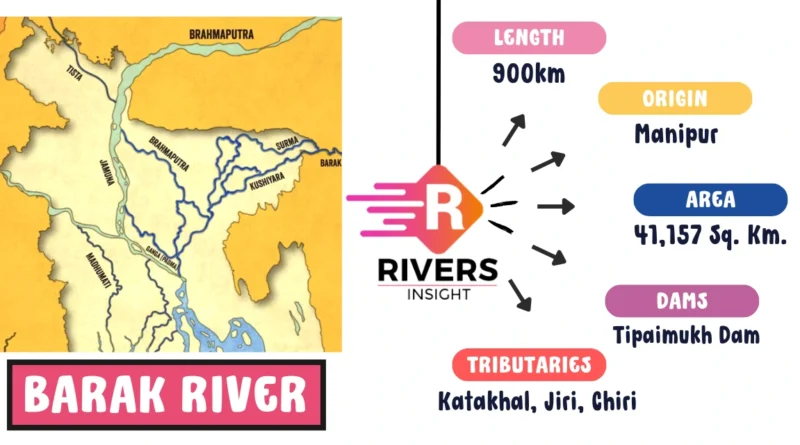
Barak River: Map & Origin with Tributaries
Advertisements
The Barak River, spanning a geographical area of 6922.00 sq. km (excluding two hill districts), stands as a crucial region distinguished by its rivers, including the Barak and its tributaries.
This article uncovers the unique features of the Barak Valley, examining its geography, tributaries, drainage areas, and the challenges it faces.
| River | Barak |
| Length | 900 km |
| Origin | Manipur |
| Area cover | 41,157 sq. km |
| Major Dam | Tapaimukh Dam |
| Tributaries | Katakhal, Jiri, Chiri |
Table of Contents
Geographical Overview
- Land of Flowing Waters: The Barak Valley, with its main river, the Barak, and tributaries such as Katakhal, Jiri, Chiri, Modhura, Longai, Sonai, Rukni, and Singla, grapples with flood issues due to the rain-fed nature of these waterways.
- Transnational Drainage: The Barak sub-basin not only spans India but also parts of Bangladesh and Burma, covering approximately 1.38% of India’s total geographical area. Bounded by the Barail range, Na Lushai hills, and Bangladesh, it extends across states like Meghalaya, Manipur, Mizoram, Assam, Tripura, and Nagaland.
Hydrography and Physiography
- Barak’s Origin: The Barak River originates from Japvo mountain in Manipur hills, meandering through mountainous terrain until it reaches Tipaimukh near the tri-junction of Assam, Manipur, and Mizoram.
- Course and Borders: Flowing through Assam’s Cacher district, the river defines the border between Assam and Manipur up to Jirimat. It then traverses the Barak Valley before entering Bangladesh as Surma and Kushiyara, eventually merging into the Meghna River.
- Navigability and Borders: The Barak River spans 524 km in India, with a significant part along the Indo-Bangladesh border. The upper navigable stretch covers 121 km between Lakhipur and Bhanga, declared as National Waterway 6 (NW-6) in 2016.
Hydropower Potential and Major Projects of Barak River
- Untapped Energy: The Barak River boasts a hydropower potential of 3908 MW at a 60% load factor, presenting opportunities for sustainable energy development.
- Strategic Projects: Major projects like the Tipaimukh Dam Project, Tista Champamati, and Dhansiri barrages underline efforts to harness the region’s water resources for economic growth.
Challenges and Solutions
- Flood Menace: The Brahmaputra-Barak basin faces annual floods, impacting an extensive area of approximately 4.33 million hectares. This perennial challenge necessitates robust mitigation measures.
- Erosion Woes: Beyond floods, towns, and villages grapple with the erosive actions of rivers, requiring comprehensive strategies to address the socio-economic impact.
Must read: Major Rivers of India
Conclusion
Advertisements
The Barak Valley, with its intricate network of rivers, diverse geography, and hydropower potential, stands at the intersection of challenges and opportunities. Navigating these waters requires a holistic approach, combining environmental sustainability with socio-economic resilience to ensure the prosperity of the region and its inhabitants.