Damodar River: Origin, Map, Course, Tributaries, Dams & States
Damodar River, often called the Sorrow of Bengal, is a major river of eastern India flowing through Jharkhand and West Bengal. With a total length of 592 km, it forms an important part of the Ganga River System.
This article explains the Damodar River’s origin, course, basin, tributaries, dams and the Damodar Valley Project in a simple and exam-friendly manner.
| Length | 592 km |
| Origin | Chota Nagpur |
| Flows through | Jharkhand and West Bengal |
| Known as | Sorrow of Bengal |
| Basin Area | ~25,820 sq. km |
| Confluence | Hooghly River |
Table of Contents
Geographical Features of Damodar River
Origin and Course of Damodar River
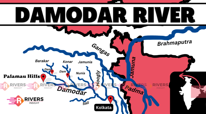
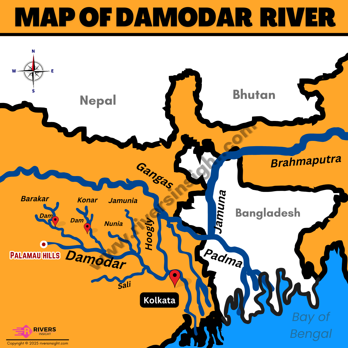
Damodar River originates from the Palamau hills of Chota Nagpur in Jharkhand. This hill is situated at an elevation of approximately 600 meters above sea level.
As the river flows, it traverses through several districts in Jharkhand, including:
- Hazaribagh
- Ramgarh
- Giridih
- Dhanbad
- Bokaro
In West Bengal, it covers:
- Burdwan
- Hooghly
In its lower course, it flows through West Bengal’s plains and is joined by several tributaries. Finally, the Damodar River meets the Hooghly River at Shayampur which is 48 km from Kolkata.
Map of Damodar River in India
Drainage Basin
The Damodar River’s drainage basin extends across Jharkhand and West Bengal in India. It covers 11.8% of the total geographical area of Jharkhand and 8.6% of West Bengal. Further, the basin has a total catchment area of 25,820 km² and is a part of the Ganga River System.
To study other rivers that flow through these states, refer to Rivers of Jharkhand and Rivers of West Bengal.
Mineral Wealth of the Damodar Basin
The basin is known for its rich mineral deposits, including:
- Coal (almost half of India’s total coal reserves)
- Mica
- Fireclay
- Bauxite
- Limestone
- China clay
- Baryte
- Ironstone
Tributaries
The Damodar River has several tributaries, including:
- Barakar River
- Konar River
- Jamunia River
- Bokaro River
- Sali River
- Ghari River
- Guaia River
- Khadia River
- Bhera River
Dams
Damodar River is known for its several dams and barrages, which help control flooding, provide hydroelectric power, and support irrigation in the region. Some of the notable dams and barrages are:
- Maithon Dam
- Panchet Dam
- Tilaiya Dam
- Konar Dam
Damodar Valley Project
The Damodar Valley Project is a significant river valley project in Eastern India, implemented to supply hydroelectric power to West Bengal and Bihar, as well as to prevent floods effectively. The project is operated by the Damodar Valley Corporation (DVC), an undertaking of the Indian Government established in July 1948.
The Damodar Valley Project is situated on the Konar River in the district of Hazaribagh in Jharkhand. The Damodar River, a tributary of the Hugli River, flows from west to east through West Bengal and Jharkhand. The project’s objectives include water supply for domestic and industrial use, flood control, and transmission of electrical energy.
The main objectives are:
- Control floods
- Irrigation
- Checking soil erosion
- Generate hydroelectric power
- Supply water
- Promotion of public health
Damodar Valley Project has also contributed to the development of agriculture, industries, fish breeding, afforestation, and recreation in the region.
FAQs
Where does the Damodar River originate?
The Damodar River originates from the Chota Nagpur Plateau in Palamu district, Jharkhand. Its source lies near Khamarpat Hill, at an elevation of about 609 meters.
Damodar River flows through which states?
The Damodar River primarily flows through two Indian states: Jharkhand and West Bengal. In Jharkhand, it passes through industrial and mining towns like Ranchi, Dhanbad, and Bokaro. After entering West Bengal, it flows through areas such as Asansol and Bardhaman before draining into the Hooghly River.
Damodar is a tributary of which river?
The Damodar River is a tributary of the Hooghly River, a major distributary of the Ganges. After flowing across eastern India, the Damodar meets the Hooghly near the town of Falta in West Bengal.