Kathajodi River with Map
In eastern India, the Kathajodi River flows through the Cuttack district of Odisha. It is a significant distributary of the Mahanadi River and branches off at Naraj. This river winds through Cuttack and provides essential water resources for the local population.
Odisha is located on the eastern coast of India, bordered by West Bengal to the northeast, Jharkhand to the north, Chhattisgarh to the west, and Andhra Pradesh to the south. Consequently, the Kathajodi River is a crucial part of Odisha’s geography. Moreover, it supports agriculture, boosts local industries, and sustains everyday life.
Origin and Course of Kathajodi River
The Kathajodi River is formed by the bifurcation of the Mahanadi River at Naraj which flows parallel to Brahmani River. The Kathajodi River flows northwards and forms a separate channel that winds through the Cuttack district.
From Naraj, the Kathajodi River flows eastward and meanders through the city of Cuttack, which is a significant urban center where the river plays a crucial role in daily life and activities; notably, landmarks along its path include:
- The Barabati Fort
- The Odisha State Museum
These landmarks are situated close to the river’s banks.
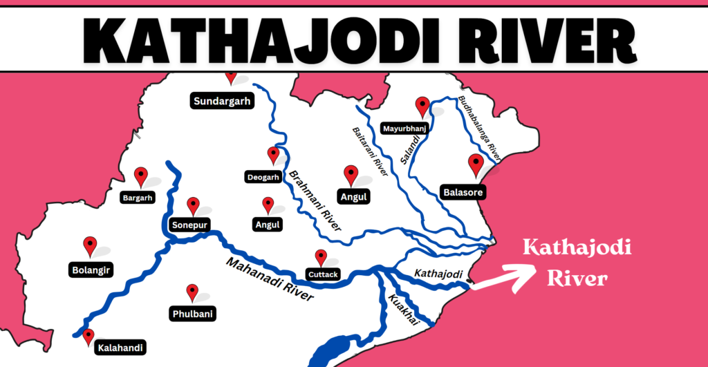
As the river continues, it passes through important towns such as Jobra and Niali. In Jobra, the river is regulated by the Jobra Barrage to manage its flow and support local irrigation systems. Furthermore, further downstream in Niali, it provides essential water resources for agriculture and sustains the local economy.
Eventually, the Kathajodi River flows parallel to the Mahanadi River and both rivers eventually discharge into the Bay of Bengal.