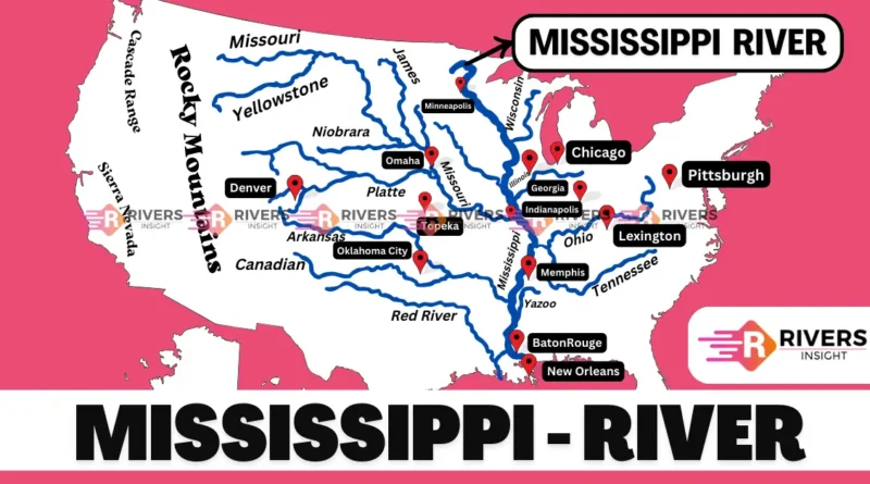
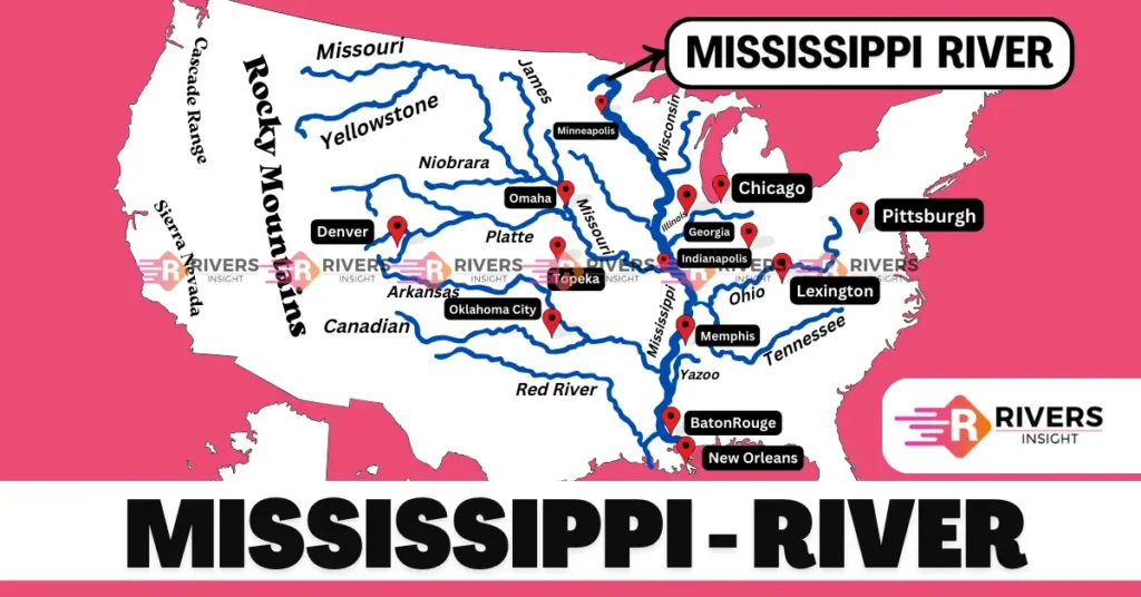
Mississippi River with Map and Tributaries
Mississippi River is located in the central part of the United States of America (USA) and is one of the major rivers in the world. It originates at Lake Itasca in Minnesota and has a total length of approximately 3734 km, stretching to the Gulf of Mexico. It is the 4th longest river in the world, and the second-longest river in North America, after the Missouri River.
Moreover, its name originates from the Ojibwe language, meaning “Great River,” and it is also known by several nicknames, including “Old Man River” and “Father of Waters.” As it flows along 10 states in the USA, the Mississippi River has played a vital role in shaping the country’s history, economy, and culture.
| River | Mississippi River with Map and Tributaries |
| Length | 3734 km |
| Origin | Minnesota |
| Area | 3.1 million sq. km. |
| Mouth | Gulf of Mexico |
Table of Contents
Geographical Features of the Mississippi River
Origin and Course of Mississippi River
The Mississippi River originates at Lake Itasca in Clearwater County, Minnesota, USA. Lake Itasca is a small glacial lake located in Itasca State Park, approximately 1,475 feet (450 meters) above sea level.
The Mississippi River passes through the following 10 states:
- Minnesota
- Wisconsin
- Iowa
- Illinois
- Missouri
- Kentucky
- Tennessee
- Arkansas
- Louisiana
- Mississippi
As the Mississippi River enters Iowa, it charts a southeasterly course for approximately 310 miles (500 km), tracing the Iowa-Missouri border. Upon entering Missouri, the river continues its southeasterly flow for another 735 miles (1,183 km).
The river passes through the charming cities of Keokuk, Iowa, and Hannibal, Missouri, famously known as the childhood home of the celebrated American author, Mark Twain. As it winds through the Missouri River Valley, the river flows through the vibrant cities of St. Louis and Cape Girardeau.
The River then forms the border between Missouri and Illinois for approximately 100 miles (161 km) before entering the state of Kentucky, continuing its majestic journey through the heart of America. Then it flows southeast from Kentucky through Tennessee and Arkansas for about 550 miles. It goes through the cities of Cairo, Illinois, and Memphis, Tennessee, before entering Arkansas.
Then, the river flows southeast through Louisiana for about 390 miles, passing through the cities of Baton Rouge and New Orleans.
Finally, the Mississippi River flows into the Gulf of Mexico, about 100 miles southeast of New Orleans, Louisiana. The river spreads out into a big delta before flowing into the Gulf.
Map of Mississippi
Drainage Basin
- The Mississippi River basin covers an area of approximately 3.1 million square kilometers)
- The river basin drains over 40% of the continental United States.
- The basin spans across 31 states and 2 Canadian provinces.
- Any precipitation that falls within this area eventually ends up in the Mississippi River.
- It is the 15th largest river in the world by water discharge volume, releasing 16,792 cubic meters (593,003 cubic feet) of water per second into the Gulf of Mexico.
- The basin is home to over 60% of the country’s agricultural land, producing a significant portion of the nation’s food and fiber.
The Mississippi River basin is prone to flooding, with the most significant flood in recent history being the Great Mississippi Flood of 1927, which displaced over 640,000 people and caused $1 billion in damages (equivalent to over $15 billion today).
Tributaries of Mississippi
- Missouri River: The longest tributary, flowing from Montana to St. Louis, Missouri.
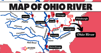
- Ohio River: Formed in Pittsburgh, Pennsylvania, it flows southwest to Cairo, Illinois, and joins the Mississippi.
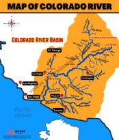
- Arkansas River: Originating in the Rocky Mountains of Colorado, it flows into the Mississippi River in Arkansas.
- Tennessee River: Rising in the Appalachian Mountains of Tennessee, it joins the Ohio River in Kentucky.
- Cumberland River: Also originating in the Appalachian Mountains of Kentucky, it flows into the Ohio River.
- White River: Flowing from the Ozark Mountains of Arkansas.
- Red River: Spanning Texas and Oklahoma, it connects with the Atchafalaya River in Louisiana, which then flows into the Mississippi River.
- Illinois River: Flowing from Illinois, it joins the Mississippi River in Illinois.
Historical Significance
The Mississippi River has a long and interesting history. Many Native American tribes, such as the Quapaw, Ojibway, and Algonquian, lived near the river and used it for fishing, farming, and trading. European explorers, like Hernando de Soto, Louis Jolliet, and Jacques Marquette, also traveled on the river in the 16th and 17th centuries.
The French were the first Europeans to settle in the valley and established cities like New Orleans, St. Louis, and Arkansas Post. These settlements helped to shape the history of the region and the United States as a whole.