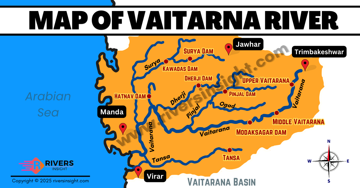
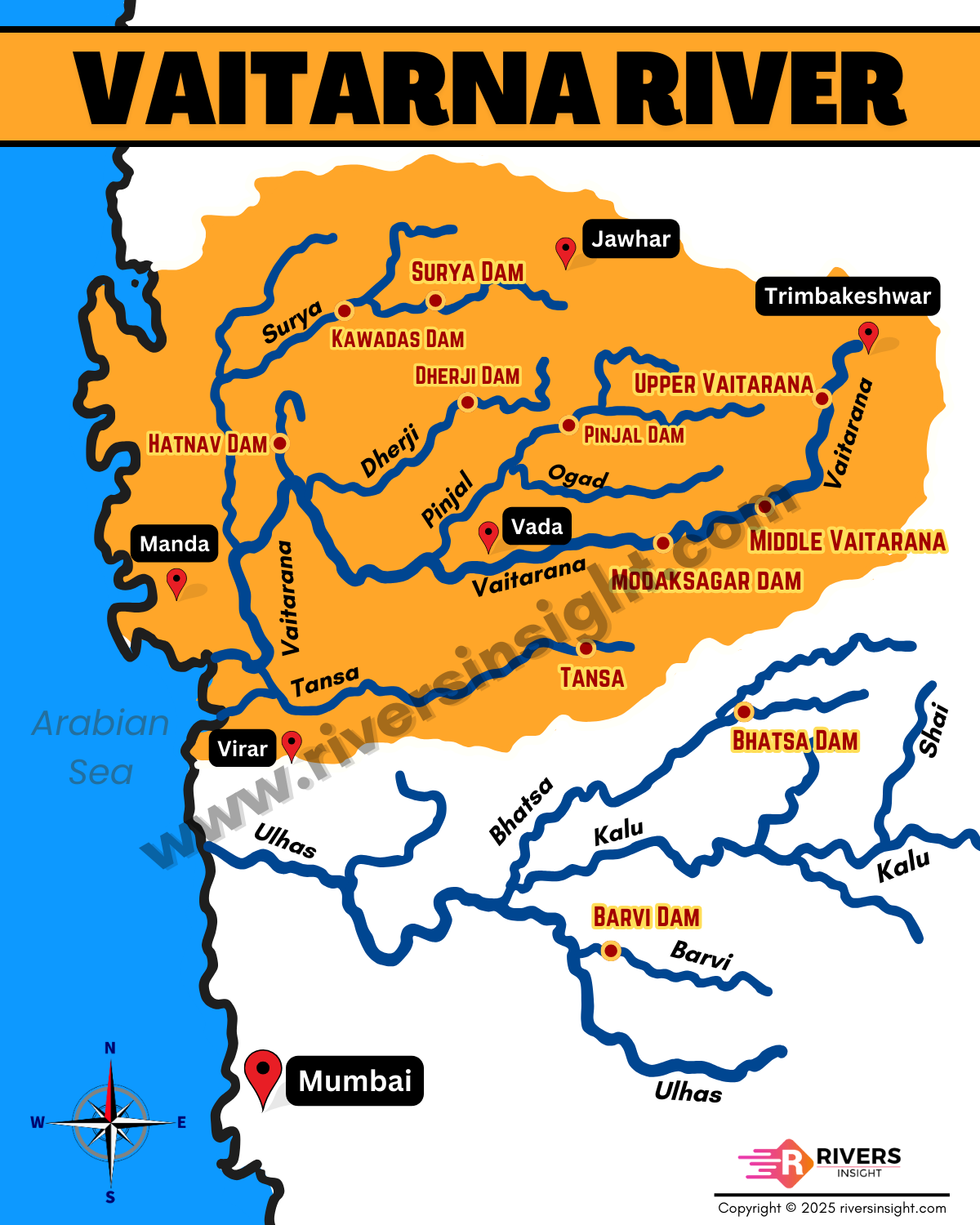
Vaitarna River: Map of Maharashtra with Dams
The Vaitarna River is one of the major west-flowing rivers of northern Maharashtra. It originates in the Western Ghats and flows through the Nashik, Thane, and Palghar districts before draining into the Arabian Sea. Moreover, one of the major structures built on this river is the Upper Vaitarna Dam.
Table of Contents
Origin and Course of Vaitarna River
The Vaitarna River originates from the southern slopes of the Triambak-Anjaneri hills near Trimbakeshwar in the Nashik district of Maharashtra. These hills are part of the Sahyadri ranges (Western Ghats) and are also the origin point of the sacred Godavari River.
From the Triambak-Anjaneri range, the river begins as three small southward-flowing streams, which combine a little north of Dapure village to form the main channel of the Vaitarna River.
After its formation, the river follows a highly winding course, curving around Zarwad (Jarwar) Budruk. Just south of this point, it is joined by the Alvand River, an important tributary whose headstreams rise from the Bhaskargad, Phani Dongar, and Harish Dongar hills, forming the natural divide between the south-flowing rivers and the Val River flowing northwards.
Following the confluence with the Alvand, the Vaitarna flows in a south-south-west direction, cutting a deep gorge through the escarpment of the Western Ghats. As it moves downstream, a smaller tributary joins from the northwest, continuing the river’s journey through a narrow and deeply cut valley.
Finally, the Vaitarna River flows westward through Thane and Palghar districts and drains into the Arabian Sea near Arnala village on the Konkan coast.
Major Tributaries
- Alvand River
- Tansa River
- Pinjal River
- Surya River
- Dahanu River
- Ganjai River
Map of Vaitarani with Dams
Basin and Drainage Area
The Vaitarna basin is one of the prominent west-flowing river systems located north of Mumbai and south of the Tapi River. The entire catchment area of the river lies within the Thane and Nashik districts of Maharashtra.
- Total Length: Approximately 154 km
- Basin Area: Around 2,019 km²
Rainfall Pattern
The Vaitarna River basin receives almost all its rainfall from the southwest monsoon, mainly from June to October. Remarkably, about 98% of the annual rainfall is received in this period, making it a highly seasonal river in terms of water volume.
Major Dams on the Vaitarna River
Several dams have been constructed on the river and its tributaries, primarily to serve Mumbai’s water needs and support regional development:
- Vaitarna Hydro Electric Project (Upper Vaitarna) – Vaitarna River
- Surya Project – Surya River
- Modak Sagar (Lower Vaitarna) – Vaitarna River
- Wandra Project – Wandria River
- Deharji River Project – Deharji River
- Tansa Dam – Tansa River
Socio-Economic and Cultural Significance
- Urban Utility: Over 60% of Mumbai’s water comes from the Vaitarna and its associated dams.
- Agriculture: Water farmlands across Palghar and Thane districts.
- Cultural Relevance: The river’s origin near Trimbakeshwar makes it spiritually important for many Hindu devotees.