Narmada River System: India Map & Major Tributaries
The Narmada River, central India’s lifeline, starts in Madhya Pradesh’s Maikal Range and flows through Gujarat and Maharashtra before emptying into the Arabian Sea. The name “Narmada” comes from Sanskrit and means “the giver of pleasure.” This name shows how much people in India respect the river.
This article provides a comprehensive overview of the Narmada River, featuring a detailed map of its course and geographical features, including tributaries, dams, length, origin, and more.
| River | Narmada |
| Length | 1312 km |
| Origin | Amarkantak Plateau |
| Mouth | Arabian Sea |
| Position | India’s fifth-longest |
Table of Contents
Narmada River System
The Narmada River, known locally as the Reva, stands as India’s fifth-longest river and the longest westward-flowing one in the nation. It holds the title of the largest river system within the state it courses through. It runs through a rift valley, winding between the Satpura and Vindhya mountains, making it one of India’s significant rivers shaped by this geological feature.
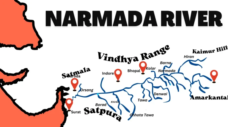
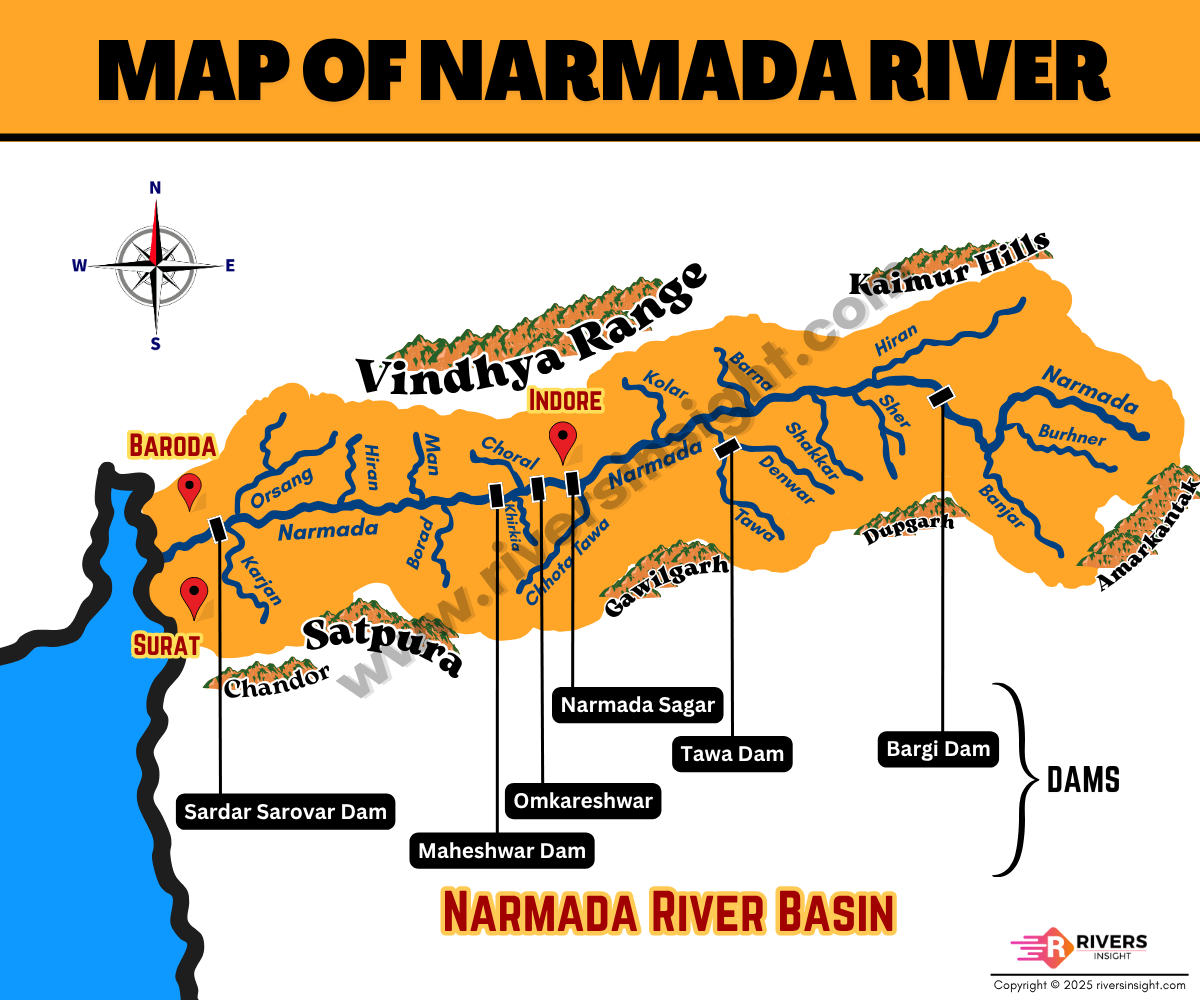
Map of Narmada River in India
Origin of Narmada
The Narmada River starts from the Amarkantak Plateau in the Maikala range, in eastern Madhya Pradesh. It begins at a height of 1,057 meters above sea level and travels for 1,312 kilometers before joining the Gulf of Cambay in the Arabian Sea near Bharuch, Gujarat.
Course
River begins its journey at the peaceful Amarkantak Plateau in Madhya Pradesh. It flows steadily through valleys and fields, touching the lives of many people along the way, until it finally joins the Arabian Sea in Gujarat.
Along its course, it passes through major cities and locations, including:
- Amarkantak Plateau, Madhya Pradesh (Origin)
- Jabalpur, Madhya Pradesh
- Hoshangabad, Madhya Pradesh
- Omkareshwar, Madhya Pradesh
- Maheshwar, Madhya Pradesh
- Narmada district, Gujarat
- Bharuch, Gujarat (Mouth)
During its journey, it shapes the landscapes and forms natural boundaries between states:
- It meanders through Madhya Pradesh for about 1,079 kilometers.
- It marks the border between Madhya Pradesh and Maharashtra for 35 kilometers.
- It separates Maharashtra and Gujarat for 39 kilometers.
- Finally, it flows through 159 kilometers in Gujarat before reaching the sea.
Narmada River Basin
The Narmada River basin is a huge area of 98,796 square kilometers in central India. It’s surrounded by the Vindhya and Satpura mountain ranges to the north and south, the Maikala range to the east, and the Arabian Sea to the west.
Most of it is less than 500 meters above sea level, with fertile plains and hills supporting farming and settlements. However, places like Panchmarhi are over 1,000 meters high, adding scenic variety. This basin not only gives birth to the Narmada River but also plays a big role in the area’s environment and economy.
Drainage Area
The Narmada River basin is distributed across three states:
- Madhya Pradesh: 85,859 sq. km.
- Maharashtra: 1,538 sq. km.
- Gujarat: 11,399 sq. km.
Waterfalls on Narmada
The Narmada River is dotted with several beautiful waterfalls along its course. Some notable waterfalls include:
- Dhuandhar Falls: Located near Jabalpur in Madhya Pradesh, these falls are known for the mist (“Dhuan”) they create as the water cascades down the rocky terrain.
- Bhedaghat Falls: Also situated near Jabalpur, these falls are famous for their marble rocks and boat rides amidst stunning natural scenery.
- Kapildhara Falls: Found near Amarkantak in Madhya Pradesh, these falls are believed to be where the sage Kapil meditated, adding a spiritual significance to their beauty.
- Maheshwar Waterfalls: Located near the town of Maheshwar in Madhya Pradesh, these falls are surrounded by lush greenery and offer a serene retreat for visitors.
- Sardar Sarovar Dam Waterfalls: These man-made waterfalls are created by the overflow from the Sardar Sarovar Dam on the Narmada River in Gujarat, offering a mesmerizing sight during the monsoon season.
Tributaries of the Narmada River
Here are the left and right bank tributaries of the Narmada River:
Right Bank Tributaries:
- The Barna River
- Hiran River
- Tendoni River
- Choral River
- Kolar River
- Man River
- Uri River
- Hatni River
- Orsang River
Left Bank Tributaries:
- Buehner River
- Banjar River
- Sher River
- Shakkar River
- Dudhi River
- Tawa River
- Ganjal River
- Chhota Tawa River
- Kaveri River
- Kundi River
- Goi River
- Karjan River
Dams on the Narmada River System
| Dam Name | Location |
|---|---|
| Sardar Sarovar Dam | Navagam, Gujarat |
| Indira Sagar Dam | Narmada Nagar, MP |
| Omkareshwar Dam | Omkareshwar, MP |
| Bargi Dam | Jabalpur, MP |
| Jobat Dam | Jobat, MP |
| Maheshwar Dam | Maheshwar, MP |
In central India, the Narmada River is a vital resource, supporting agriculture, electricity generation, and livelihoods. Its extensive basin and network of tributaries, along with strategic dams, highlight its crucial role in the region’s development. As it flows through states like Madhya Pradesh, Maharashtra, and Gujarat, the Narmada remains a symbol of harmony between nature and human society, enriching both with its abundant waters.
If you’d like more information or have any questions, please feel free to leave a comment below.
More related links: