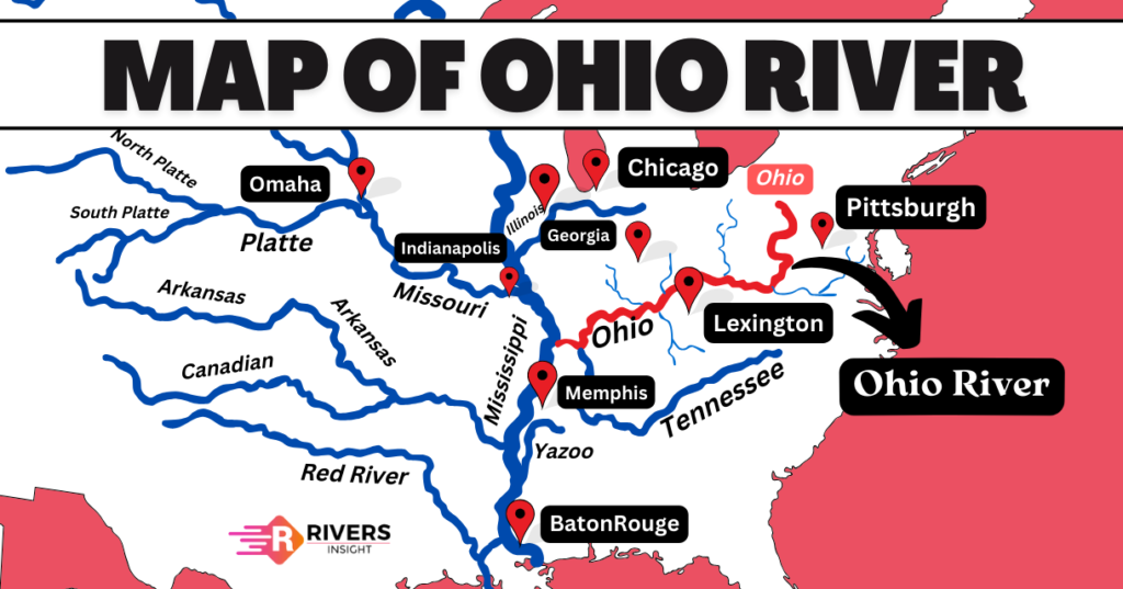
Ohio River: On the Map of the United States
The Ohio River is the major left-bank tributary of the Mississippi River in the United States of America. It receives its name from the Iroquois word “O-Y-O” meaning “the great river“. Furthermore, France was the first to claim the Ohio River, which they called “La Belle Viviere“, or the beautiful river. In addition, the Ohio River begins at Pittsburgh, Pennsylvania where the Allegheny and Monongahela Rivers come together and is located at the boundary of the Midwestern and Southern United States.
This article will look at the Ohio River’s origin, the area it drains, its path with a map of the United States, and its main features, giving a clear and concise overview of this important river.
Table of Contents
Geographical Features of the Ohio River
The Ohio River is located in the eastern United States and stretches 1,579 kilometers. As the largest tributary by volume of the Mississippi River, it flows through or borders six states and has a drainage basin that covers 14 states.
Origin and Course
The Ohio River begins where the Allegheny and Monongahela rivers unite at Point State Park in Pittsburgh, Pennsylvania. From Pittsburgh, the river flows in a northwest direction through Allegheny and Beaver Counties. Then, it suddenly turns to the south-southwest at the point where the states of West Virginia, Ohio, and Pennsylvania meet.
From this point, the river forms the border between West Virginia and Ohio, above the town of Wheeling, West Virginia. After that, the river generally flows in a southwest direction, then turns to the west-northwest, and finally bends back to a west-southwest direction for most of its length. Finally, it joins the Mississippi near the city of Cairo, Illinois.
Boundaries
Further, it marks the boundaries of five states: Ohio and West Virginia, Ohio and Kentucky, Indiana and Kentucky, and Illinois and Kentucky. It flows along the borders of the following six states:
- Pennsylvania
- Ohio
- West Virginia
- Kentucky
- Indiana
- Illinois
Major Cities Along the River
In Ohio, these cities include Cincinnati, Gallipolis, Marietta, Portsmouth, and Steubenville. In Indiana, they include Madison, New Albany, Evansville, and Mount Vernon. In West Virginia, they include Parkersburg, Huntington, and Wheeling. In Kentucky, they include Ashland, Covington, Louisville, Owensboro, and Paducah.
Location and Map of Ohio River
Drainage Basin
The Ohio River’s drainage basin covers an area of approximately 204,000 square miles (528,000 square kilometers), making it one of the largest in the United States. The basin includes parts of 15 states:
- Illinois
- Indiana
- Kentucky
- Maryland
- New Jersey
- New York
- North Carolina
- Ohio
- Pennsylvania
- Tennessee
- Virginia
- West Virginia
Tributaries
The Ohio River has several major tributaries, including:
- Wabash River
- Muskingum River
- Miami River
- Hocking River
- Great Kanawha River
- Guyandotte River
- Licking River
- Green River
- Cumberland River
- Tennessee River
So, in this article, we have covered information on the Ohio River, including its geographical features like origin, course, tributaries, etc. We hope you found this information helpful and informative, and we welcome your feedback on how we can improve our content!