Ramganga River: Map, Origin, Course & Tributaries
The Ramganga River is an important river of the Ganga river system in northern India. It flows through Uttarakhand and Uttar Pradesh before joining the Ganga.
There are actually two different rivers known as Ramganga in Uttarakhand: Ramganga West and Ramganga East. They have different sources and follow different courses. Ramganga West flows into Uttar Pradesh and joins the Ganga, while Ramganga East originates in Pithoragarh and joins the Sarju River.
This article explains both rivers, with the main focus on Ramganga West, which is the major tributary of the Ganga.
Table of Contents
Ramganga River: Quick Facts
| Feature | Ramganga West |
|---|---|
| River system | Ganga |
| Origin | Doodhatoli Range, Uttarakhand |
| Length | About 596 km |
| States | Uttarakhand and Uttar Pradesh |
| Major tributary of | Ganga |
| Major dam | Ramganga Dam |
| Dam location | Kalagarh |
| Important tributaries | Ban, Khoh, Gangan, Gagas, Aril, Kosi, Haldgadi Rao and Deoha |
| Confluence | Ganga in Uttar Pradesh |
| Basin | Ramganga sub-basin of the Ganga Basin |
| Basin Area | 30,839 sq km. |
Ramganga West River
The Ramganga West is the river generally referred to simply as the Ramganga River when discussing the Ganga river system.
It originates in the Doodhatoli ranges of Pauri Garhwal, Uttarakhand. From the himalayan mountains, it flows through the foothill region before entering the plains at Kalagarh. It then continues through Uttar Pradesh and eventually joins the Ganga.
The river has a total length of about 596 km. Along its course, the landscape changes from mountainous terrain to the broad plains of northern India.
Origin & Course of Ramganga
Ramganga West originates in the Doodhatoli range of Pauri Garhwal district in Uttarakhand.
The Pauri Garhwal district administration specifically identifies the Western Ramganga as originating from the Doodhatoli ranges.
The upper course of the river passes through the mountains and foothills of Uttarakhand.
The river reaches Kalagarh, where the Ramganga Dam has been constructed. Beyond Kalagarh, the river enters the plains and flows in a generally southeasterly direction through Uttar Pradesh. It eventually joins the Ganga on its left bank.
The change from a mountainous river to a plains river is one of the main features of its course.
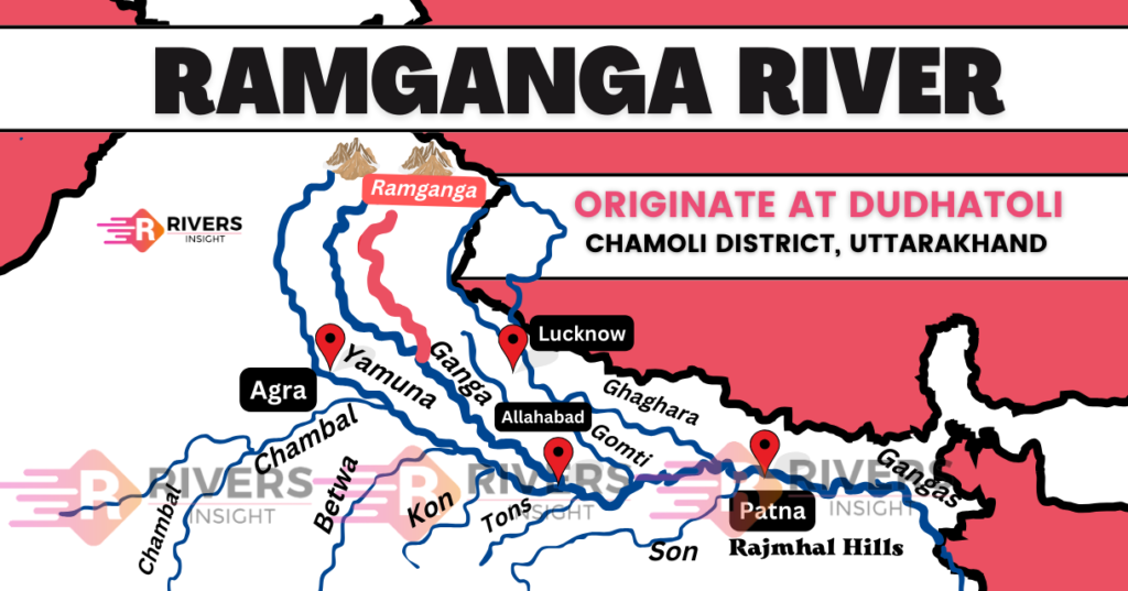
Ramganga River Map
The map shows the course of Ramganga West from its source in Uttarakhand to its confluence with the Ganga in Uttar Pradesh.
Cities Along Ramganga
The Ramganga West River is also home to several cities, including
- Moradabad
- Bareilly, Badaun
- Shahjahanpur
- Hardoi
Tributaries of the Ramganga
Important tributaries listed by official source include:
- Ban
- Khoh
- Gangan
- Gagas
- Aril
- Kosi
- Haldgadi Rao
- Deoha
These rivers and streams drain different parts of the Ramganga sub-basin and contribute to the flow of the main river.
Ramganga Dam
The Ramganga Dam, also known as the Kalagarh Dam, is one of the most important projects associated with the river.
It is located at Kalagarh and forms part of the Ramganga multipurpose project.
According to the Uttarakhand Irrigation Department, the dam is an earth and rockfill dam 128 metres high. Its powerhouse has an installed capacity of 198 MW. The project provides for irrigation, hydroelectric power and flood relief. Construction began in 1962 and was completed in 1975.
Ramganga East River
The Ramganga East is a separate river from Ramganga West.
It originates from the Namik Glacier in Pithoragarh district of Uttarakhand. The river receives water from several smaller and larger streams as it flows through the Kumaon region. It eventually joins the Sarju River at Rameshwar.
The Eastern Ramganga therefore follows a different drainage route from Ramganga West. It does not flow through Uttar Pradesh to join the Ganga like the Western Ramganga.
Ramganga West vs Ramganga East
| Feature | Ramganga West | Ramganga East |
|---|---|---|
| Source | Doodhatoli ranges | Namik Glacier |
| Region | Pauri Garhwal and adjoining Himalayan/foothill areas | Pithoragarh and Kumaon |
| Flows towards | Uttar Pradesh | Kumaon region |
| Joins | Ganga | Sarju |
| Major project | Ramganga Dam | — |
| River system | Ganga | Sarju–Kali system |
The two rivers should therefore not be treated as two branches of one river. They are separate rivers that share the name Ramganga. The Pithoragarh district administration separately identifies the eastern Ramganga and its connection with the Sarju.