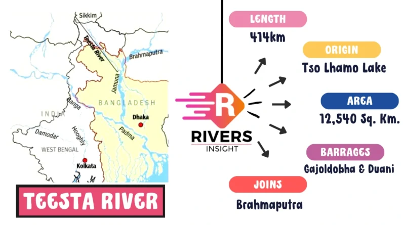
Teesta River in India Map with Origin
The Teesta River, originating from Tso Lhamo Lake at an elevation of approximately 5280 m in North Sikkim, is a significant right-bank tributary of the Brahmaputra river system. Like many major Himalayan rivers, including the Ganga, the Teesta is glacier-fed, with sources like Pahurni Glacier, Khangse Glacier, and ChhoLhamo Lake contributing to its flow.
Recognized as a valuable resource, the Teesta River holds immense potential for hydroelectricity generation, catering to the energy needs of Sikkim’s cities.
| River | Teesta |
| Origin | Tso Lhamo Lake |
| Tributary of | Brahmaputra River |
| Length | ~414 km |
Table of Contents
Geographical Distribution of Teesta River
- The Teesta River basin is situated between India and Bangladesh.
- About 83% of the basin lies in India, predominantly in the mountainous terrains of Sikkim and West Bengal, while the remaining 17% is in Bangladesh.
- Teesta is the fourth-largest river shared by India and Bangladesh, extending from Sikkim in India through West Bengal to the northern Rangpur division in Bangladesh.
Further, the Teesta River joins the Brahmaputra in Bangladesh, ultimately merging with the Ganges and the Meghna before flowing into the Bay of Bengal. In Bangladesh, the Teesta joins the Brahmaputra on its right bank, taking on the name Yamuna, and later merging with the Padma, finally reaching the Bay of Bengal.
Historically, the Teesta River system was considered a major tributary of the Ganges, emphasizing its importance in the region’s hydrology.
The Teesta basin is home to approximately 30 million people, with 2% residing in Sikkim, 27% in West Bengal, and 71% in northwest Bangladesh. The diverse terrain of Sikkim, West Bengal, and Bangladesh ranges from mountainous with low population density to a mix of low hills and plains, and nearly flat, respectively.
Two major barrages, Gajoldobha in India and Duani in Bangladesh, have been constructed on the Teesta to divert water primarily for irrigation purposes.
In addition, the River has both left and right-bank tributaries, with the left-bank tributaries originating from smaller snowfields and the right-bank tributaries draining heavily glaciated areas with large snowfields. Major tributaries include Lachung Chhu, Dik Chhu, and Rangpo Chhu on the left bank, and Rangit River on the right bank.
The upper Teesta River basin is characterized by glacial features, debris accumulation, debris avalanches, and rock glaciers. The middle and lower Teesta River basin exhibit a relatively less steep slope and subdued relief. Teesta and its tributaries flow with high velocity, carrying boulders and suspended sediments, especially throughout Sikkim. The upper part of the basin experiences sub-zero temperatures in winter, rising to around 20 °C during the peak summer season.
Also read: Mahi River: Origin and Map with Tributaries