Vaigai River: Map and Origin
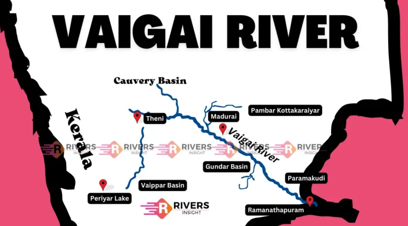
Vaigai River is located in southern India, within Tamil Nadu state. It begins in the Periyar Plateau of the Western Ghats, and its course runs southeast through the districts of Theni, Dindigul, and Madurai, before emptying into the Palk Strait of the Bay of Bengal.
On a map of India, the Vaigai River is located in the southern region, specifically in Tamil Nadu. A detailed map of Tamil Nadu shows the river flowing from the western part of the state to the southeastern coastline.
| River | Vaigai |
| Origin | Periyar Plateau |
| State | Tamil Nadu |
| Length | 258 km |
| Catchment | 7,121 sq. km. |
Geographical Features of the Vaigai River
- Origin: It originates from the Western Ghats in the Periyar Plateau, flowing southeast.
- Length: Spans a total length of 258 kilometers.
- Drainage Area: Covers a drainage area of 7,121 square kilometers.
- Tributaries: Major tributaries include Siruliar, Varaha Nadhi, Gundar, and Thenkaraiyar.
- Vaigai Dam: Vaigai Dam is a key irrigation and hydroelectric power structure.
- Waterfalls: Features several waterfalls: Kumbakarai Falls, Suruli Falls, Thalaiyar Falls, and Vaigai Dam Falls.
Tributaries
The Vaigai River, coursing through the southern state of Tamil Nadu in India, is augmented by several tributaries from the surrounding hills and plateaus.
1. Siruliar River
Originating from the Western Ghats near Kodaikanal, the Siruliar River embarks on a 35-kilometer journey before merging with the Vaigai River near Andipatti. Its waters contribute to the flow and richness of the Vaigai, supporting the surrounding ecosystem.
2. Varaha Nadhi
Flowing from the Palani Hills, the Varaha Nadhi stretches for 128 kilometers before joining the Vaigai River near the town of Theni. Its course adds volume and diversity to the Vaigai’s waters, enhancing the river’s significance in the region.
3. Gundar River
Emerging from the Western Ghats, the Gundar River traverses 80 kilometers before converging with the Vaigai near Narasingapuram. Its waters augment the Vaigai’s flow, which is crucial in sustaining the ecosystem along its path.
4. Thenkaraiyar River
Originating in the Western Ghats, the Thenkaraiyar River flows for 41 kilometers before meeting the Vaigai near Kamudi. Its contribution enhances the Vaigai’s resources, supporting the flora and fauna along its banks.
5. Kottagudi River
Beginning its journey in the Anamalai Hills, the Kottagudi River travels for 42 kilometers before merging with the Vaigai near Melmangalam. Its waters add to the vitality of the Vaigai, enriching the riverine ecosystem it nourishes.
So, that’s a wrap on our discussion about the Vaigai River, covering its geographical features and tributaries. If you have any questions, please feel free to ask in the comment section below.
Also read: Peninsular Rivers of India