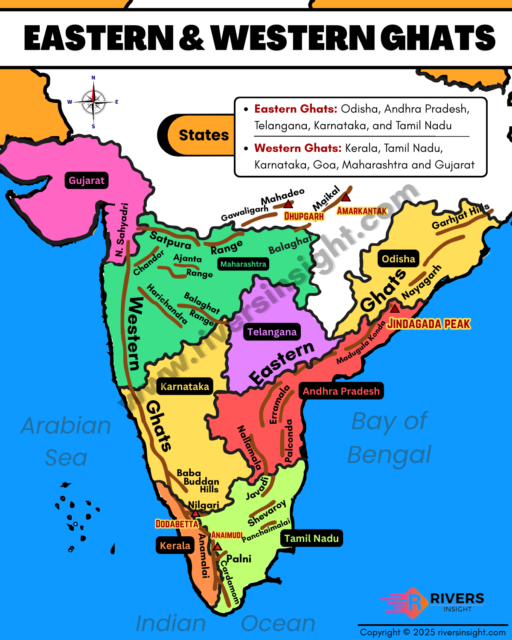
Western Ghats & Eastern Ghats: Physical Features & Map
In peninsular India, two major hill ranges are found – the Western Ghats and the Eastern Ghats. The Western Ghats are also called Sahyadri and they are continuous mountains running parallel to the western coast, from Gujarat down to Kerala and Tamil Nadu. Meanwhile, the Eastern Ghats are discontinuous ranges spread along the eastern coast, from Odisha to Tamil Nadu.
In this article, we will study both the Western Ghats and the Eastern Ghats in detail. We will look at their location, formation, and physical features. Moreover, we will also cover important hills, peaks, rivers, and sections with the help of simple explanations and tables. This will give a clear comparison of the two ranges and their role in shaping peninsular India.
Table of Contents
Western Ghats (Sahyadri Range)
Western Ghats were formed by the subduction of the Arabian basin and the tilting of the peninsular land during the Himalayan uplift. On the western side, they rise steeply like block mountains, while the eastern side slopes gently into the Deccan plateau. Along the west coast, their appearance is like steps or terraces, locally called “Treppen.”
Local Names
- Sahyadri (Maharashtra)
- Nilgiri Hills (Karnataka & Tamil Nadu)
- Anaimalai & Cardamom Hills (Kerala)
Physical Features of Western Ghats
- Elevation: Average 1,500 m, height increases from north to south
- Length: Approx. 1600 km
- Six States Covered: Gujarat, Maharashtra, Goa, Karnataka, Kerala, Tamil Nadu
- Major Rivers: Godavari, Krishna, Kaveri
- Highest Peak: Anamudi (2,695 m) in Annamalai Hills, Kerala
- 2nd Highest Peak: Doddabetta (2,637 m) in Nilgiri Hills, Tamil Nadu
- Hill Stations: Ooty, Munnar, Kodaikanal
- Biodiversity Hotspot: UNESCO World Heritage Site, one of the eight hottest biodiversity hotspots
- Age: Older than Himalayas
- Total Stretch: Tapi valley to Kanyakumari
Major Hills and Peaks of the Western Ghats (North to South)
| Range / Hill | Highest Peak | States Covered |
|---|---|---|
| Sahyadri Hills | Kalsubai (1,646 m) | Gujarat, Maharashtra, Goa |
| Harishchandragad | 1,424 m | Maharashtra |
| Salher | 1,567 m | Maharashtra |
| Balaghat Hills | ~1,200 m | Maharashtra |
| Ajanta Hills | 600–900 m | Maharashtra |
| Baba Budan Hills | Mulangiri (~1,900 m) | Karnataka |
| Kudremukh Hills | 1,892 m | Karnataka |
| Vavul Mala Hills | 2,339 m | Kerala / Karnataka |
| Nilgiri Hills | Doddabetta (2,637 m) | Karnataka, Kerala, Tamil Nadu |
| Anaimalai / Annamalai Hills | Anamudi (2,695 m) | Kerala, Tamil Nadu |
| Palani Hills | 900–1,200 m | Tamil Nadu |
| Cardamom Hills / Ealaimalai | Agastimalai (~1,868 m) | Kerala, Tamil Nadu |
| Brahmagiri Hills | 1,608 m | Kerala / Karnataka |
Sections of Western Ghats
Western Ghats are divided into three distinct sections based on geography, geology, and elevation to better describe their varying terrain, climate, and ecological characteristics, as each part has its own unique features, peaks, rivers, and ecosystems.
1. Northern Western Ghats
Northern Western Ghats extend from the Tapi valley in Gujarat to 16°N latitude, covering parts of Gujarat, Maharashtra, and Goa. This region is mostly made of basaltic lava (Deccan Traps), giving it a rugged and dissected terrain. The western slopes are steep while the eastern side gradually merges into the Deccan plateau.
Key Features:
- Average Height: ~1,200 m, with higher peaks in some areas
- Important Peaks: Kalsubai (1,646 m), Salher (1,567 m), Mahabaleshwar (1,438 m), Harishchandragarh (1,424 m)
- Major Rivers: Godavari, Tapi, Mandovi, and other smaller west-flowing rivers
- Passes: Thal Ghat, Bhor Ghat (road and rail connections)
- Vegetation: Dense forests, heavy rainfall along western slopes
2. Middle Western Ghats (Central Sahyadri)
Middle Western Ghats extend from approximately 16°N latitude down to the Nilgiri Hills, covering parts of Maharashtra, Karnataka, and Kerala. This section is mainly composed of granites and gneisses and is densely forested. The western slopes are steep and deeply cut by rivers, while the eastern side gradually merges with the Deccan plateau.
Key Features:
- Average Height: ~1,200 m, with many peaks exceeding 1,500 m
- Major Peaks:
- Vavul Mala – 2,339 m
- Kudremukh – 1,892 m
- Pashpagiri – 1,714 m
- Doddabetta (Nilgiris) – 2,637 m
- Makurti – 2,554 m
- Mulangiri (Baba Budan Hills, Karnataka) – highest point in Karnataka section
- Nilgiri Hills: Join the Western Ghats near the trijunction of Karnataka, Kerala, and Tamil Nadu, rising abruptly above 2,000 m; this area marks the junction of the Western and Eastern Ghats
- Major Rivers: Sharavathi, Kaveri, Krishna, Tungabhadra
- Waterfalls: Jog Falls, Gersoppa Falls
3. Southern Western Ghats
Southern Western Ghats are separated from the main Sahyadri range by the Palghat Gap (Palakkad Gap), a rift valley that connects the plains of Tamil Nadu with the coastal plain of Kerala. This gap also allows southwest monsoon clouds to penetrate inland, bringing rainfall to regions like Mysore. South of the Palghat Gap, the mountains form a complex system of steep and rugged slopes on both eastern and western sides. This region is also referred to as the Southern Mountain Complex.
Key Features:
- Highest Peaks:
- Anamudi (2,695 m): Highest peak in southern India, located in Annamalai Hills
- Dodabetta (2,637 m): Highest peak of Nilgiris
- Agastimalai: Highest peak of Cardamom Hills
- Major Ranges:
- Nilgiris
- Annamalai Hills
- Cardamom Hills (Ealaimalai)
- Palani Hills (transverse range)
- Average Elevation: 1,600 – 2,500 m
- Major Rivers: Periyar, Bhavani, Vaigai, Kallar, Pambar
- Palghat Gap: Separates the southern Western Ghats from the main Sahyadri, used by roads and railways
- Mountain Layout: Three major ranges radiate from Anamudi:
- Anaimalai Hills: North of Anamudi (1,800–2,000 m)
- Palani Hills: Northeast of Anamudi (900–1,200 m)
- Cardamom Hills: South of Anamudi
Eastern Ghats
The Eastern Ghats are a series of discontinuous and highly broken hills running almost parallel to India’s east coast. They extend from the Mahanadi River in Odisha to the Vaigai River in Tamil Nadu, passing through Andhra Pradesh, Telangana, and parts of Karnataka and Tamil Nadu. Unlike the Western Ghats, the Eastern Ghats are fragmented, lack structural unity, and appear as isolated hill groups, forming broad plains between their base and the coast.
The Ghats almost disappear between the Godavari and Krishna rivers but reappear further south as isolated hills and plateaus. They are geologically Precambrian fold mountains, contemporary with the Aravalli ranges, and now appear as denudation hills with average elevations of 150–300 m in the lowland areas.
Physical Features of Eastern Ghats
- Length: ~1,750 km
- Width: 100–200 km (variable)
- Highest Peaks: Jindhagada Peak (AP, 1,690 m)
- 2nd Highest Peak: Mahendragiri (Odisha, 1,501 m)
- Five States Covered: Odisha, Andhra Pradesh, Telangana, Tamil Nadu, Karnataka
- Character: Discontinuous, broken, low to medium elevation, not continuous like Western Ghats
Major Rivers of the Eastern Ghats
- Mahanadi
- Brahmani
- Subarnarekha
- Godavari
- Indravati
- Krishna
- Penna (Pennar)
- Cauvery / Kaveri
- Vellar
- Vaigai
Major Hills of the Eastern Ghats
| Hills / Range | Highest Peak | States Covered |
|---|---|---|
| Madugula Konda Hills | Jindhagada Peak (1,690 m) | Andhra Pradesh |
| Nallamalai Hills | ~600–850 m | Andhra Pradesh |
| Palkonda Hills | ~600–800 m | Andhra Pradesh |
| Vellikonda Hills | ~1,100 m | Andhra Pradesh |
| Shevaroy Hills | Yercaud Peak (1,623 m) | Tamil Nadu |
| Javadi Hills | ~1,500 m | Tamil Nadu |
| Kalrayan Hills | ~1,000 m | Tamil Nadu |
| Biligiri Rangan Hills | 1,279 m | Karnataka / Tamil Nadu |
| Eastern Ghats of Odisha | Mahendragiri (1,501 m) | Odisha |