Missouri River | Map, Length, Source, Dams & Facts
Missouri River is the longest river in North America and one of the most important river systems in the United States. Flowing across the central part of the country, it serves as the largest tributary of the Mississippi River.
Missouri River has been known by several names throughout history. Early French maps recorded it under different names, but the modern name is derived from the Missouri Native American tribe. The river is widely known by its nickname, “Big Muddy,” due to the large amount of sediment it carries.
Key Facts – Missouri River
| Feature | Details |
|---|---|
| Length | ~2,341 miles (3,767 km) |
| Source | Rocky Mountains, Montana |
| Mouth | Mississippi River near St. Louis |
| Country | United States |
| Basin Area | ~529,000 sq miles (1.37 million sq km) |
| Rank | Longest river in North America |
Table of Contents
Origin & Course of Missouri River
Missouri River begins in the Rocky Mountains of western Montana. It forms where the Jefferson, Madison, and Gallatin rivers meet near Three Forks.
After entering North Dakota, the river gradually turns southeast. It continues in this direction through South Dakota, flowing past major locations such as Bismarck and Pierre. Along its course, the river forms natural boundaries between several states, including:
- South Dakota and Nebraska
- Nebraska and Iowa
- Nebraska and Missouri
- Kansas and Missouri
Near Kansas City, the river turns east and begins to meander across Missouri. As it approaches Jefferson City, it shifts direction again before finally flowing eastward to meet the Mississippi River just north of St. Louis.
Drainage Basin
The Missouri River basin is one of the largest drainage systems in North America. It covers approximately 529,000 square miles (1.37 million square kilometers), which is about one-sixth of the United States.
Geographic Extent
The basin stretches across a vast and diverse region:
- From the Rocky Mountains in the west
- To the Mississippi River Valley in the east
- From southern Canada in the north
- To the Arkansas River watershed in the south
It includes all or parts of 10 U.S. states, including Montana, North Dakota, South Dakota, Nebraska, Kansas, Iowa, and Missouri.
Elevation Range
One of the defining features of the Missouri River basin is its wide range of elevations:
- Highest elevations: ~14,000 feet in the Rocky Mountains
- Lowest elevation: ~400 feet at the Mississippi River confluence
Map of the Missouri River
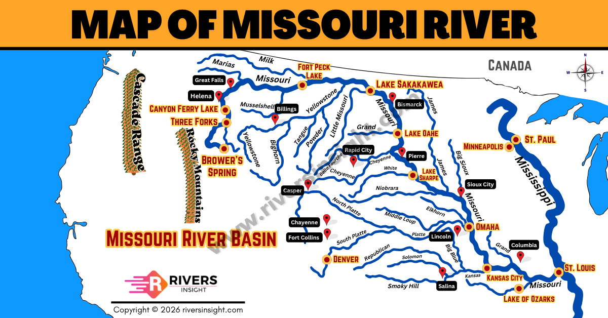
Major Tributaries
Missouri River is fed by many important tributaries. Some of the major ones include:
- Yellowstone River
- Platte River
- Kansas River
- White River
- Osage River
- Milk River
- James River
- Niobrara River
- Grand River
- Cheyenne River
Missouri River Mainstem Dams
Missouri River has been extensively developed with a series of large dams along its main channel. These dams play a major role in flood control, water storage, hydroelectric power generation, and navigation.
The first major dam built on the Missouri River was Fort Peck Dam in Montana. It was authorized under the Rivers and Harbors Act of 1935 and marked the beginning of large-scale river development.
During the mid-20th century, additional dams were constructed under the Pick-Sloan Plan, a major federal project designed to manage water resources across the Missouri River basin. This development was carried out by the U.S. Army Corps of Engineers (USACE) and the Bureau of Reclamation (BOR).
Major Mainstem Dams
The six main dams on the Missouri River are:
- Fort Peck Dam (Montana)
- Garrison Dam (North Dakota)
- Oahe Dam (South Dakota)
- Big Bend Dam (South Dakota)
- Fort Randall Dam (South Dakota)
- Gavins Point Dam (South Dakota/Nebraska)
Reservoirs Created by the Dams
Each of these dams forms a large reservoir, which stores water and helps regulate river flow:
- Fort Peck Lake
- Lake Sakakawea
- Lake Oahe
- Lake Sharpe
- Lake Francis Case
- Lewis and Clark Lake
River Management System
Missouri River dam system is managed by the U.S. Army Corps of Engineers under a framework known as the Master Water Control Manual (Master Manual).
Originally developed in 1960 and later updated (most recently in 2004), this manual guides how water is released and stored across the system. It balances multiple uses of the river, including:
- Flood control
- Navigation
- Hydropower generation
- Water supply
- Environmental protection