Sabarmati River: Complete with Map & Bridges
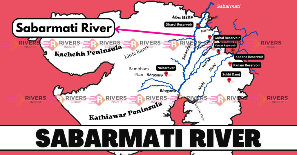
Sabarmati River is a significant river in the western region of India, formed by the confluence of the Sabar and Hathmati rivers. According to historical records, the Sabarmati River was previously known as Svabhramati, which translates to “river of ravines,” due to its unique path that winds through the rugged terrain.
Additionally, it flows in a southwestern direction, passing through Udaipur in Rajasthan and several districts in Gujarat, including Sabarkantha, Mehsana, Gandhinagar, Ahmedabad, and Anand.
Table of Contents
Geographical Features of Sabarmati River
The Sabarmati River is a seasonal river that flows strongly during the monsoon season and then slows down. It flows through Rajasthan and Gujarat then, it eventually meets the Arabian Sea at the Bay of Khambhat. The river is 371 kilometers long, with 323 kilometers in Gujarat and 48 kilometers in Rajasthan. It passes through Ahmedabad city, which is located on its banks.
Origin and Couse of Sabarmati River
The Sabarmati River originates from the Dhebar Lake, situated in the southeast of the Aravalli Range in Rajasthan’s Udaipur district. From its source, the river flows in a southwest direction, traversing a total distance of approximately 371 kilometers before emptying into the Gulf of Khambhat in the Arabian Sea.
As it flows through the plains, the Sabarmati River enters the state of Gujarat and passes through several districts, including:
- Sabarkantha
- Mehsana
- Gandhinagar
- Ahmedabad
About 170 kilometers from its source, it meets its major tributary, the Hathmati River. Further downstream, it is joined by another tributary, the Vatrak River, approximately 65 kilometers from Ahmedabad.
Notably, The Sabarmati River is a monsoon-fed river. Additionally, its flow is supplemented by the Narmada Canal, which ensures a consistent water supply throughout the year. Furthermore, it bisects Ahmedabad into western and eastern halves and plays a vital role in the region’s ecosystem and economy.
After flowing through Ahmedabad, the Sabarmati River continues its journey in a southwest direction, passing through the districts of:
- Kheda
- Anand
- Vadodara
As it approaches the Gulf of Khambhat, the river widens and forms a deltaic region, where it finally empties into the Arabian Sea. Further, the river’s mouth is situated near the town of Bharuch, which is an important port city in Gujarat.
Map of Sabarmati
Drainage Basin
The Sabarmati River basin covers a vast area of 21,674 square kilometers, with 4,124 square kilometers in Rajasthan and 18,550 square kilometers in Gujarat. The region experiences a semi-arid climate, receiving between 450-800 mm of rainfall annually.
Tributaries
Here are some of the notable tributaries of the Sabarmati River:
- Sei The Sei River is a primary tributary of the Sabarmati River, flowing into it from the right bank. It originates in the Aravalli hills and meets the Sabarmati River 95 km to the southwest, covering an area of 946 square kilometers.
- Vakaal (Waka) The Vakaal River, also known as Waka, is a branch of the Sabarmati River that flows from the left bank. It originates in the Aravalli hills in Rajasthan and flows southwest for 88 km, draining an area of 1625 square kilometers. Its main source of water is the Maines.
- Harnav The Harnav River is a branch of the Sabarmati River that flows to the left. It originates in the north of Kulia hills, a part of the Rajasthan range, and flows 75 km to the southwest, covering an area of 972 square kilometers. It connects to the left bank of the Sabarmati River.
- Hathmati The Hathmati River is a branch of the Sabarmati River that flows from the left bank. It originates in the southwest hills of Gujarat’s Rajasthan range and flows southwest for 122 km until it meets the Sabarmati River, covering an area of 1526 square kilometers.
- Vatrak (Waitaki) The Vatrak River, also known as Waitaki, is a branch of the Sabarmati River that flows to the left. It originates in the Panchara Hills, which are in the Dungarpur district of Rajasthan. After 248 km, it joins the Sabarmati River, draining an area of 8638 square kilometers along with its tributaries.
Dams
Following are the dams on the Sabarmati River and its tributaries:
- Dharoi Dam
- Hathmati Dam
- Harnav Dam
- Guhai Dam
- Mexico Reservoir
- Meshvo Pick-up Weir
- Mazama Dam
- Vatrak Dam
Bridges over the Sabarmati River
The Sabarmati River has several bridges that connect the cities and towns along its course, facilitating transportation and commerce. Here are some of the notable bridges:
- Ellis Bridge (Ahmedabad) Built in 1895, Ellis Bridge is one of the oldest bridges over the Sabarmati River. It connects the eastern and western parts of Ahmedabad city and is an important landmark in the city’s history. The bridge was named after Sir Barrow Helbert Ellis, the then-Commissioner of Gujarat. It was originally a pontoon bridge but was later replaced with a concrete structure in 1939.
- Nehru Bridge (Ahmedabad) Nehru Bridge, built in 1962, is another significant bridge over the Sabarmati River in Ahmedabad. It is a major transportation artery, carrying heavy vehicular traffic between the city’s eastern and western areas. The bridge was named after India’s first Prime Minister, Jawaharlal Nehru, and was inaugurated by him in 1962.
- Vasna Barrage Bridge (Ahmedabad) The Vasna Barrage Bridge, built in 2011, is a pedestrian and vehicular bridge that connects the Vasna and Danilimda areas of Ahmedabad. It offers scenic views of the Sabarmati River and the surrounding landscape. The bridge is part of the Sabarmati Riverfront Development project, which aims to revitalize the riverfront area and promote tourism.
- Dadhichi Bridge (Gandhinagar): The Dadhichi Bridge is a modern bridge that connects Gandhinagar city to the Ahmedabad-Gandhinagar highway. The bridge is named after Dadhichi, a legendary Indian sage who is said to have meditated on the banks of the Sabarmati River.
These bridges play a vital role in connecting the cities and towns along the Sabarmati River, promoting economic growth, and enhancing the quality of life for the people living in the region.
Conclusion
The river has played a significant role in the history and development of Gujarat India. Moreover, the city of Ahmedabad founded in 1411 by Sultan Ahmed Shah was established on the banks of the Sabarmati River. Furthermore, the river has also been a symbol of spirituality with the famous Sabarmati Ashram established by Mahatma Gandhi in 1917.
In addition, the ashram was a key location for India’s struggle for independence and it was from here that Gandhi led the Dandi March in 1930 a pivotal event in India’s fight for freedom. Today, the Sabarmati River continues to support the livelihoods of millions of people, and the dams on the river and its tributaries play a crucial role in providing water for irrigation drinking, and industrial use.