Tapi River: Map, Origin, Course, Tributaries & Facts
The Tapi River, also called the Tapti River, is one of the major west-flowing rivers of peninsular India. It originates near Multai in the Satpura Range of Madhya Pradesh and flows through Madhya Pradesh, Maharashtra, and Gujarat before emptying into the Arabian Sea near Surat.
The river is about 724 km long and is the second-longest west-flowing river in peninsular India after the Narmada River. Moreover, it is one of the three significant rivers, along with Narmada, Mahi, and Tapti, that flow from east to west in peninsular India.
In this article, you’ll find the Tapi River map, origin, starting and ending point, course, tributaries, drainage basin, dams, important cities, and key facts for UPSC and other competitive exams.
| Length | 724 km |
| Origin | Multai, Betul district, Madhya Pradesh |
| Source Range | Satpura Range |
| Starting Point | Near Multai town |
| Ending Point | Arabian Sea (Gulf of Khambhat), near Surat |
| Flows Through States | Madhya Pradesh → Maharashtra → Gujarat |
| River Type | West-flowing perennial river |
| Drainage Basin | 65,145 km² |
Table of Contents
Map of Tapi River
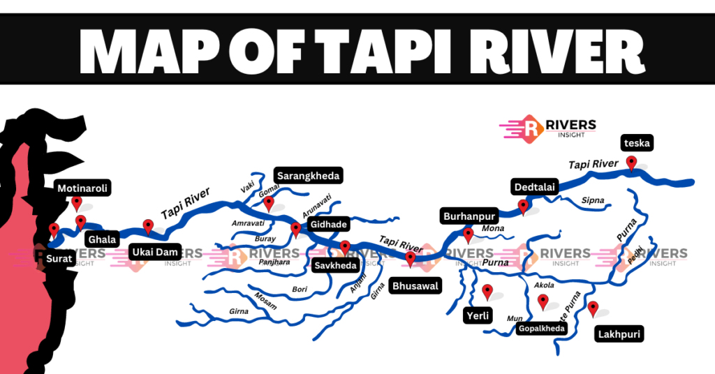
The Tapi River map shows the complete journey of the river from its source near Multai in Madhya Pradesh to its mouth in the Arabian Sea near Surat in Gujarat. It also highlights the three states through which the river flows, important cities along its course, and major tributaries joining the Tapi River.
Geographical Features of Tapi River
Origin and Course
The Tapi River originates from the Multai plateau in the Satpura Range, located in the Betul district of Madhya Pradesh, India. It rises at an elevation of about 752 meters above sea level.
In Madhya Pradesh, the river flows through the Satpura Range, where it’s joined by tributaries like the Bhawar, Bichhan, and Sur. Then, it enters Maharashtra, flowing through:
- Amravati
- Akola
- Buldhana
- Washim
- Jalgaon
- Dhule
- Nandurbar
- Malegaon
- Nashik
The Tapi River then enters Gujarat, flowing through:
- Surat
- Navsari
Here, it’s joined by the Mindhola and Kim rivers. Finally, the river empties into the Arabian Sea through a wide estuary near Surat in Gujarat.
Drainage Basin
The Tapi River drainage basin is a significant geographical feature in India, covering an area of approximately 65,145 square kilometers, which is nearly two percent of the total area of India. Almost 80% of the basin lies in Maharashtra, with the remaining areas spread across Madhya Pradesh and Gujarat.
- Maharashtra (51,504 km²)
- Madhya Pradesh (9,804 km²)
- Gujarat (3,837 km²)
The basin is located on the Deccan plateau and is limited by:
- North: Satpura range and Vindhyas
- East: Mahadev hills and Maikala range
- South: Ajanta Range and Satmala hills, and Satpuras
- West: Arabian Sea
To learn more about the major mountain ranges of India, visit our Mountain Ranges of India Section.
Tributaries of the Tapti River
The Tapti River is fed by several major tributaries on both its banks. Here’s a simple overview of these tributaries:
Right Bank Tributaries
On the right bank, the tributaries come from the Satpura Ranges. They include:
- Vaki
- Aner
- Arunawati
- Gomai
Left Bank Tributaries
In contrast, the left bank has more tributaries. These tributaries originate from different regions like Gawilgarh Hills, Ajanta Hills, and some other places of western ghats:
- Nesu
- Amravati
- Buray
- Panjhara
- Bori
- Girna
- Waghur
- Purna
- Mona
- Sipna
Important projects in Tapi Basin
- Ukai Dam in Gujarat
- Girna Dam in Maharashtra
- Kakrapar Dam in Gujarat
- Hatnur Dam in Maharashtra
- Gosikhurd Irrigation Project in Maharashtra
- Sarangkheda Project in Maharashtra
- Lower Tapi Irrigation Project in Gujarat
- Bhusawal Thermal Power Station near Maharashtra’s Tapi River
What are your thoughts? Do you have any suggestions or feedback? Your insights are really valuable in helping us improve our content!