Cauvery River System: Detailed Map & Tributaries of Kaveri
The Cauvery River, often referred to as the Ganga of the South, originates from the Western Ghats in Karnataka. It flows through the states of Tamil Nadu and Kerala before finally emptying into the Bay of Bengal. Its expansive basin covers approximately 81,155 square kilometers, covers different types of landscapes, from thick forests to fertile plains.
In this article, we’ll explore the Cauvery River’s map, geographical features, tributaries, dams, length, origin, and course. Join us as we follow its path from the mountains to the sea, observing how human activities have influenced its journey.
| River | Cauvery or Kaveri |
| Length | 805 |
| Origin | Kodagu district of Karnataka |
| Merge in | Bay of Bengal |
| Cities along | Mettur, Kumbakonam, Erode, etc |
Table of Contents
Cauvery River System
The Cauvery River, also called Kaveri, is a major river in South India. It stretches 805 kilometers long and 245 kilometers wide. Known as the “Ganga of the South,” it’s the third largest river in the southern region, after the Godavari and Krishna rivers. Its flow from the Western Ghats to the Bay of Bengal shapes the lives of many communities in Southern India.
Origin
The Cauvery River originates from the Brahmagiri hills (1,341m) in Karnataka’s Kodagu district. Talakaveri, near Bhagamandala, is commonly recognized as the river’s source and holds significant religious importance for Hindus. Surrounded by the Brahmagiri hills near the border with Kasaragod district in Kerala, Talakaveri serves as a revered pilgrimage site, marking the beginning of the sacred journey of the Cauvery River.
Course
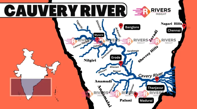
The Cauvery River begins its journey at Talakaveri, where it originates. Along its course towards the Krishnaraja Sagara, it is joined by two significant tributaries, the Hemavati and Lakshmantirtha.
In Karnataka, it splits into two, forming Srirangapatnam and Sivasamudram islands. The Sivasamudram Falls, near here, are beautiful in the rainy season. After splitting and rejoining, it becomes the border between Karnataka and Tamil Nadu.
Further south, at Hogennekkal Falls, it enters the Mettur Reservoir. Then, it heads east into Tamil Nadu, joining other rivers along the way. Near Erode, it splits into two branches, marking the beginning of the Cauvery Delta.
After joining back together, it forms Srirangam Island, where the Grand Anicut, built by a Chola King, is located. Below this, it divides into the Cauvery and Vennar branches, creating a network of small branches throughout the delta.
Finally, before reaching the Bay of Bengal near Poompuhar, it breaks into many smaller rivers, forming the lush delta known as the “garden of southern India.”
Cities Along the Course of Kaveri River
Here’s a list of major cities along the course of the Cauvery River:
- Mettur
- Kumbakonam
- Erode
- Srirangapatna
- Mysuru
- Karur
- Shivanasamudra
- Thanjavur
- Sivasamudram
Waterfalls
Here is a list of notable waterfalls along the Cauvery River:
- Shivanasamudra Falls: Located near the town of Shivanasamudra in Karnataka, these falls are among the largest and most famous on the Cauvery River. Divided into two sections, Gaganachukki and Bharachukki.
- Hogenakkal Falls: Situated in Tamil Nadu, near the border with Karnataka, Hogenakkal Falls is often referred to as the “Niagara of India.” The river cascades down a series of rocky outcrops, creating a breathtaking spectacle. Visitors can also enjoy boat rides in the turbulent waters.
- Barachukki Falls: Another segment of the Shivanasamudra Falls is located in the Mandya district of Karnataka.
Cauvery River Basin
The Cauvery River Basin spans a total area of 81,155 square kilometers, distributed across different states and union territories. In Karnataka, it covers 34,273 square kilometers, while in Tamil Nadu, it extends over 43,856 square kilometers. Kerala contributes 2,866 square kilometers to the basin, and the Union Territory of Pondicherry accounts for 160 square kilometers.
Geographical Boundaries
- Western Boundary: The Western Ghats
- Eastern and Southern Boundaries: The Eastern Ghats
- Northern Boundary: Ridges Separating from Tungabhadra and Pennar Basins
Tributaries of Cauvery
Left Bank Tributaries:
- Harangi
- Hemavati
- Shimsha
- Arkavati
Right Bank Tributaries:
- Lakshmantirtha
- Kabbani
- Suvarnavati
- Bhavani
- Noyil
- Amaravati
Dams
The following table listing the dams on the Cauvery River along with their locations:
| Dam Name | Location |
|---|---|
| Krishna Raja Sagara | Karnataka (near Mysuru) |
| Mettur | Tamil Nadu (near Salem) |
| Kabini | Karnataka (near Mysuru) |
| Hemavati | Karnataka (Hassan district) |
| Harangi | Karnataka (Kodagu district) |
| Bhavanisagar | Tamil Nadu (Erode district) |
| Amaravati | Tamil Nadu (near Tiruppur) |
| Banasura Sagar | Kerala (Wayanad district) |
| Moyar | Tamil Nadu (Nilgiris district) |
| Solaiyar | Tamil Nadu (Nilgiris district) |
Significance
The Cauvery River holds great historical importance in South India’s cultural development. It’s mentioned in ancient texts and celebrated for its beauty and life-giving qualities. Ancient kingdoms, like the influential Chola dynasty, flourished along its banks, using its waters for advanced irrigation systems and trade.
The river has witnessed significant events, such as the establishment of the Sri Ranganathaswamy Temple on Srirangam Island, a revered pilgrimage site. However, disputes over water sharing between states like Karnataka and Tamil Nadu have also occurred, showing its ongoing importance.
Besides its role in history, the Cauvery River has been a vital route for trade and transportation, enabling the movement of goods and people across the region.
So, in this article, we have explored the complete Cauvery River system, covering its origin, length, tributaries, dams, features, and course. If you have any questions or additional insights, feel free to ask in the comments below!


Thank you with all my heart! 💖