Indus River System: Sindhu Nadi Map & Tributaries
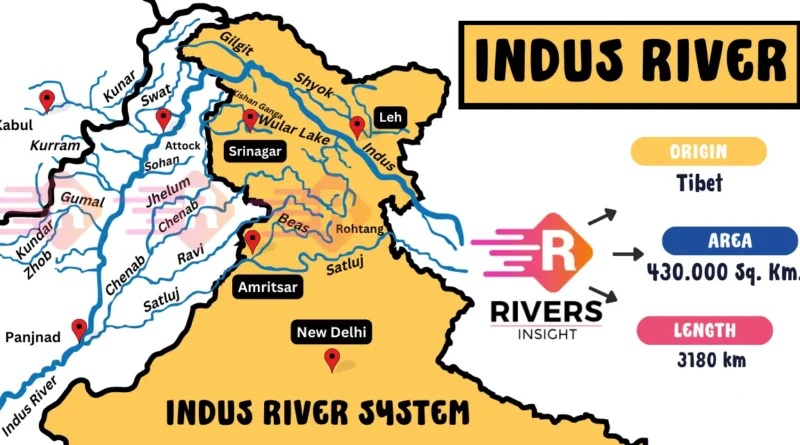
Indus River is also known as the Sindhu River in ancient times. It is one of the longest rivers in the world, with a length of about 3,180 kilometers. It originates in the Tibetan Plateau in China and flows through India and Pakistan. Moreover, the Sindhu River system is vital for millions of people living in its basin.
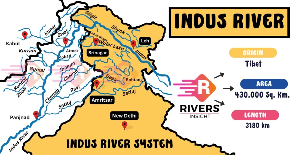
Further, the Indus River is fed by several key tributaries, and to understand its full course, you can refer to the Indus River map included in the article.
Table of Contents
Geographical Features of the Indus River
Origin and Course of Indus River
Indus River originates near Lake Mansarovar on the Tibetan Plateau. It is formed by the confluence of two major tributaries:
- Sengge Zangbo (Shiquan River)
- Gar Tsangpo
Further, the Indus River spans roughly 3,180 kilometers in length, making it one of the longest rivers in Asia. It flows through Tibet, and China, and then enters India in the Ladakh region of Jammu and Kashmir.
From Ladakh, the Indus River flows northwest and crosses several mountain ranges, including the Himalayan, Karakoram, and Sulaiman ranges, then enters Pakistan and finally empties into the Arabian Sea, forming the vast Indus Delta in southern Pakistan (Karachi).
5 Major Tributaries of the Indus River
1. Jhelum River
The Jhelum River starts from the Verinag Spring in Jammu & Kashmir and flows into Pakistan. It’s around 725 kilometers long and plays a key role in the region’s agriculture and power generation. The Mangla Dam, one of the biggest dams in Pakistan, helps control the river’s flow and store water.
2. Chenab River
Originating from Himachal Pradesh, the Chenab River travels through Pakistan, covering a distance of about 1,080 kilometers. It’s a crucial source of water for farming in Punjab and Sindh. Important dams, like the Baglihar Dam, manage the river and support agriculture and hydroelectric projects.
3. Ravi River
The Ravi River flows from India into Pakistan, running for about 720 kilometers. It’s especially important for agriculture in the Punjab region, providing essential water for crops. The Thein Dam regulates its flow, ensuring a consistent supply of water for farming and electricity generation.
4. Beas River
The Beas River starts at Beas Kund in the Himalayas and runs for 470 kilometers through Himachal Pradesh and Punjab. It’s vital for irrigation in the fertile fields of Punjab. The Pong Dam on the river controls its flow and generates hydroelectric power for the region.
5. Satluj River
The Satluj River begins in Tibet and flows through India, covering around 1,450 kilometers before entering Pakistan. It’s one of the most important rivers for irrigation in Punjab. The Bhakra Nangal Dam, built on the Satluj, provides water for farming and also generates hydroelectric power.
Left Bank Tributaries
- Jhelum River
- Chenab River
- Ravi River
- Beas River
- Sutlej River
- Zaskar River
- Suru River
- Soan River
Right Bank Tributaries
- Shyok River
- Gilgit River
- Hunza River
- Swat River
- Kunar River
- Kurram River
- Kabul River
Map of the Indus River System
Important Dams on the Indus River System
- Bhakra Dam – Satluj
- Chamera Dam – Ravi
- Pong Dam – Beas
- Baglihar Dam – Chenab
- Uri Dam – Jhelum
- Salal Dam – Chenab
- Dul Hasti Dam – Chenab
- Nangal Dam – Satluj
- Thein Dam – Ravi
If you have any questions or queries regarding the Indus River system or would like more information, feel free to comment below and we’ll be happy to assist you!

