
Mandakini River
Mandakini River originates from the Chorabari Glacier near Kedarnath in Uttarakhand, India. It is a glacier-fed Himalayan river in the Garhwal region and contributes to the larger river system among the Rivers of Uttarakhand.
Table of Contents
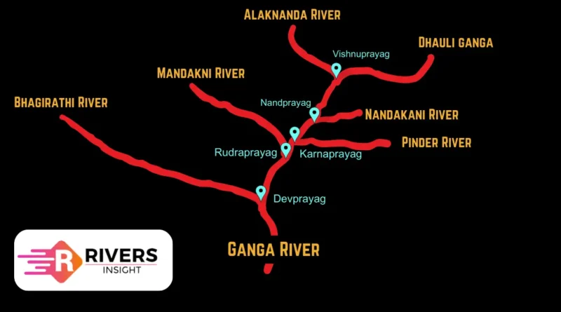
Mandakini River on Map
Mandakini River is located in Uttarakhand (Northern India) and flows entirely within the state. It forms an important part of the Ganga river system after merging with the Alaknanda.

Origin and Source
- Source: Chorabari Glacier
- Location: Near Kedarnath Temple, Uttarakhand
- Altitude: ~3,583 meters
The river begins from the Chorabari Glacier (also called Kedarnath Glacier), fed by snowmelt from surrounding Himalayan peaks, including Kedarnath Peak.
Course and Route
From its origin, the Mandakini River flows through key locations:
- Kedarnath (major pilgrimage site)
- Gaurikund (religious and trekking base)
- Sonprayag
- Tilwara
Finally, it meets the Rudraprayag, where it merges with the Alaknanda River to become part of the larger Ganga river system.
Key Facts About Mandakini River
- Length: ~80 km
- State: Uttarakhand
- River System: Ganga Basin
- Drainage Area: Garhwal Himalayas
- End Point: Confluence at Rudraprayag
Tributaries
Major tributaries of the Mandakini River include:
- Kali Ganga
- Balasuti River
- Bhilangna River
Religious Importance
- Flows through Kedarnath (Char Dham site)
- Considered a sacred river in Hinduism
- Used for rituals and holy bathing
- Important locations along the river:
- Gaurikund
- Triyuginarayan
wow, thank you so much for sharing the informative article this article is really helpful for people thank you so much again