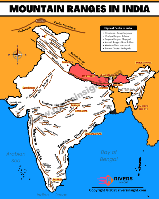
Mountain Ranges in India: Map, Himalayas, Highest Peaks & Hills
This article covers the major mountain ranges in India, their locations, highest peaks, and the key rivers originating from these mountains and hills. Prominent ranges like the Himalayas, Aravallis, Western Ghats, and Vindhyas, along with hills such as the Khasi, Garo, Nilgiri, and Baba Budan, are covered here one by one in detail with map.
Table of Contents
Major Mountain Ranges in India
1. The Himalayas
The Himalayas are the youngest and tallest mountain range in the world. They stretch about 2,500 kilometers across five countries: India, Nepal, Bhutan, China, and Pakistan. These mountains formed when the Indian tectonic plate collided with the Eurasian plate millions of years ago. Because of this, the Himalayas continue to grow even today. Moreover, this mountain range is very important because it gives rise to many major rivers such as the Ganga and Yamuna.
Geographically, the Himalayas are divided into three main sub-ranges:
- Greater Himalayas (Himadri)
- Middle Himalayas (Lesser Himalayas)
- Outer Himalayas (Shivalik Hills)
i. Greater Himalayas
The Greater Himalayas are also called Himadri or Inner Himalayas. This is the northernmost and highest part of the Himalayan range that contains famous peaks in the world. Due to their elevation and remoteness, this region remains snow-covered throughout the year and is home to massive glaciers.
Key features of the Greater Himalayas:
- Average elevation: Around 6,000 meters
- Highest peak of world: Mount Everest (8,849 m), located in Nepal on the border with China
- Highest peak in India: Kangchenjunga (8,598 m), located on the Sikkim-Nepal border
- Other important peaks: Nanda Devi, Kamet, and Namcha Barwa
- Major glaciers: Gangotri Glacier and Satopanth Glacier
- River sources: The Ganga and Yamuna originate from glaciers in this range.
ii. Middle Himalayas (Lesser Himalayas)
The Middle Himalayas lie just south of the Greater Himalayas. They are also known as the Lesser Himalayas or Himachal. This range is lower in height but still very significant in terms of geography and human settlement. Unlike the snow-covered Himadri, the Middle Himalayas are covered with thick forests and have a milder climate.
Key features of the Middle Himalayas:
- Elevation: Ranges between 3,700 and 4,500 meters
- Popular mountain ranges: Pir Panjal (Jammu & Kashmir), Dhauladhar (Himachal Pradesh), and Nag Tibba (Uttarakhand)
- Hill stations: Shimla, Mussoorie, Nainital, Ranikhet, and Dharamshala
- Vegetation: Rich forests of oak, pine, and deodar
iii. Outer Himalayas (Shivalik Hills)
The Outer Himalayas form the southernmost range of the Himalayan system. They are also called the Shivalik Hills. This is the lowest range among the three and lies closest to the plains of northern India. Unlike the higher ranges, the Shivaliks are newer in geological terms and are made of loose rocks and sediments.
Key features of the Outer Himalayas:
- Elevation: Between 1,500 and 2,000 meters
- Width: Varies from 10 to 50 kilometers
- Length: Stretches for about 2,400 kilometers from the Indus River in the west to the Brahmaputra in the east
- Local names: Dafla Hills (Assam and Arunachal Pradesh), Miri Hills, Abor Hills, Mishmi Hills, Dundwa Range (Arunachal Pradesh), Churia Range (Nepal)
- Important feature: Formation of Doon valleys (like Dehradun) between the Shivalik and Middle Himalayas
2. The Trans-Himalayas
The Trans-Himalayas lie to the north of the Greater Himalayas, mostly in the union territory of Ladakh and parts of Tibet. These ranges are often called the “Tibetan Himalayas” and are older than the main Himalayan ranges. Unlike the steep and forested southern slopes, the Trans-Himalayas have dry, cold, and barren landscapes, resembling a cold desert.
Key features of the Trans-Himalayas:
- Location: Northern Ladakh and southern Tibet
- Major ranges: Zanskar Range, Ladakh Range, Kailash Range
- Climate: Cold desert with very low rainfall
- Important rivers: Indus River flows through this region
- Mount Kailash: A sacred peak in the Kailash range, important in Hinduism, Buddhism, and Jainism
3. Karakoram and Hindu Kush Range
The Karakoram and Hindu Kush ranges lie in the northwestern part of the Indian subcontinent. Importantly, these ranges include some of the tallest peaks in the world, glaciers, and major river origins. Due to their extreme heights and cold climate, the region is sparsely populated and difficult to access.
Location:
- Karakoram is mainly located in India (Ladakh region) and Pakistan
- Hindu Kush extends further west into Afghanistan.
Key features of the Karakoram and Hindu Kush:
- Location: Jammu & Kashmir (Ladakh), Pakistan, and Afghanistan
- Highest peak: K2 (Mount Godwin-Austen) – 8,611 meters, the second-highest mountain in the world (located in Gilgit-Baltistan, under Pakistan-administered territory)
- Important glaciers: Siachen Glacier (one of the longest in the world), Baltoro Glacier, Hispar Glacier, Biafo Glacier
- Rivers: Indus, Shyok, Nubra, Gilgit
- River sources: Indus River originates from near the Kailash range and flows through the Karakoram
- Strategic value: Home to important passes like Karakoram Pass, Khardung La, Sasser Pass
4. Aravalli Range
The Aravalli Range is one of the oldest mountain ranges in the world. It was formed over 1.5 billion years ago during the Precambrian era through gradual folding and faulting of the Earth’s crust. Unlike the young and high Himalayas, the Aravallis are much older and lower in height.
Key features of the Aravalli Range:
- Length: About 692 kilometers, running from Delhi to Gujarat
- Highest peak: Guru Shikhar (1,722 meters) in Mount Abu, Rajasthan
- States: Rajasthan, Haryana, Gujarat
- Vegetation: Dry deciduous forests and scrub
- Important rivers originating here: The Luni River and Sahibi River
- Climate effect: Helps block the Thar Desert’s desertification towards the east
5. Vindhya Range
The Vindhya Range lies in central India and forms a natural divide between northern and southern India. These hills were formed through geological uplift and erosion over millions of years. Geographically, they stretch mainly across Madhya Pradesh, with extensions into Uttar Pradesh, Chhattisgarh, and Gujarat. The range runs roughly parallel to the Narmada River.
Key characterstics of the Vindhya Range:
- States covered: Madhya Pradesh, Uttar Pradesh, Chhattisgarh, and parts of Gujarat
- Average elevation: 300 to 600 meters
- Highest peak: Sad-bhawna Shikhar (also known as Kalumar Peak)
- River system: The Narmada River flows just north of the range; the Chambal and Betwa rivers also originate nearby
- Cultural significance: Often referred to in Indian epics as the dividing line between Aryavarta (north) and Dakshinapatha (south)
6. Satpura Range
The name “Satpura” means “Seven Folds”, referring to the series of parallel hill ranges. The Satpura Range lies just south of the Vindhya Range and runs across central India. These hills were formed through ancient tectonic movements and are made up mostly of sandstone, basalt, and quartzite.Further, it forms the northern boundary of the Deccan Plateau.
Key features of the Satpura Range:
- States covered: Madhya Pradesh, Maharashtra, and Chhattisgarh
- Highest peak: Dhupgarh (1,350 meters) near Pachmarhi in Madhya Pradesh
- Famous hill station: Pachmarhi, known for scenic views and waterfalls
- Major rivers: The Tapi and Narmada rivers flow parallel to the Satpura hills
- Wildlife: Includes tiger reserves and national parks like Satpura National Park and Melghat Wildlife Sanctuary
7. Western Ghats
The Western Ghats are a long chain of mountains that run parallel to the western coast of India. They were formed through the uplift of the Earth’s crust along the edge of the Deccan Plateau. This range is not only a UNESCO World Heritage Site but also one of the eight “hottest hotspots” of biodiversity in the world.
Different Hills of Western Ghats:
- Sahyadri in Maharashtra
- Nilgiri Hills in Karnataka and Tamil Nadu
- Anaimalai Hills and Cardamom Hills in Kerala
Key features of the Western Ghats:
- Six-States covered: Gujarat, Maharashtra, Goa, Karnataka, Kerala, and Tamil Nadu
- Length: About 1,600 kilometers
- Highest peak: Anamudi (2,695 meters) in Kerala
- Highest Peak of Nilgiri Hills: Doda Betta (2,637 m) in Tamil Nadu
- Major rivers originating here: Godavari, Krishna, Kaveri, and Periyar
- Biodiversity: Rich in endemic species, with dense forests and protected areas like Silent Valley and Periyar National Park
8. Eastern Ghats
The Eastern Ghats are a broken chain of hills running along the eastern coast of India. They are much older than the Western Ghats but have lower elevations and are more eroded due to weathering over time. Unlike the continuous Western Ghats, the Eastern Ghats are not a single stretch of mountains. They appear as scattered hill ranges:
- Javadi Hills in Tamil Nadu
- Palkonda Hills and Seshachalam Hills in Andhra Pradesh
- Nallamala Hills in Andhra Pradesh and Telangana
- Mahendragiri Hills in Odisha
Key features of the Eastern Ghats:
- Five-States covered: Odisha, Andhra Pradesh, Telangana, Tamil Nadu, andK arnataka
- Length: Around 1,750 kilometers
- Highest peak: Jindhagada Peak (1690 m) and Arma Konda (1,680 meters) in Andhra Pradesh
- River systems: Rivers like Mahanadi, Godavari, Krishna, and Kaveri cut through these hills as they flow eastward into the Bay of Bengal.
9. Purvanchal Range
The Purvanchal Hills are a chain of mountains in the northeastern part of India. They are considered an eastern extension of the Himalayas, formed as the Himalayan ranges bend sharply southward after Arunachal Pradesh.
Key features of the Purvanchal Hills:
- States covered: Arunachal Pradesh, Nagaland, Manipur, Mizoram, Tripura, and parts of Assam
- Major hill ranges:
- Patkai Hills
- Naga Hills
- Mizo Hills (also known as Lushai Hills)
- Manipur Hills
- Dafla, Abor, and Mishmi Hills in Arunachal Pradesh
- Vegetation: Thick tropical and subtropical forests
- Rivers: Many small rivers like the Barak and tributaries of the Brahmaputra originate or flow through these hills.
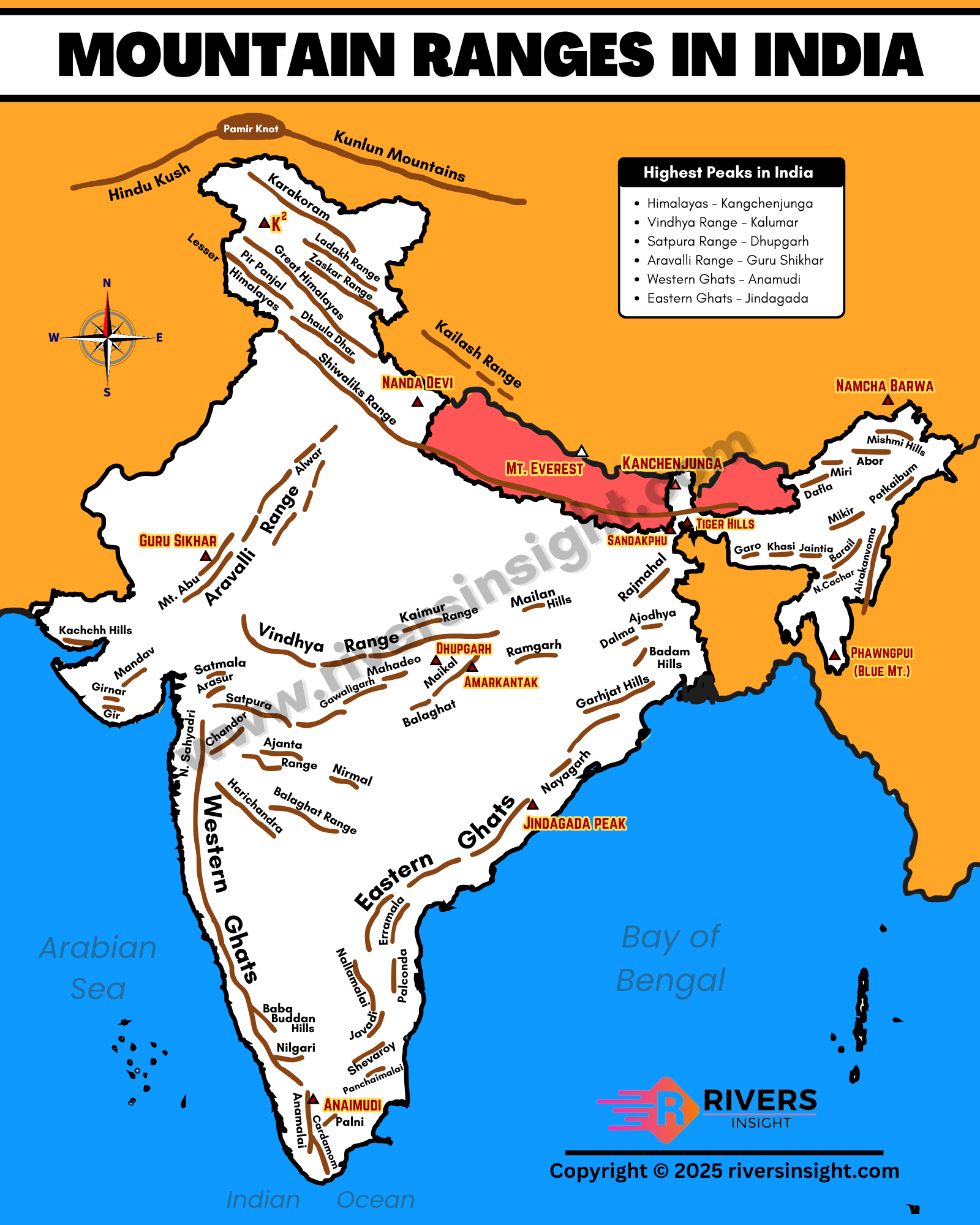
Map of Hills and Mountain Ranges in India
Highest Peaks in India
Kangchenjunga in Sikkim is the highest peak in India at 8,586 meters. Meanwhile, Mount Everest stands at 8,849 meters and is the tallest mountain in the world but lies in Nepal.
| Rank | Peak Name | Height (meters) | Location | Range |
|---|---|---|---|---|
| 1 | K2 (Godwin-Austen) | 8,611 | Gilgit-Baltistan (Pakistan-administered, claimed by India) | Karakoram |
| 2 | Kangchenjunga | 8,586 | Sikkim-Nepal border | Himalayas |
| 3 | Nanda Devi | 7,816 | Uttarakhand | Garhwal Himalayas |
| 4 | Kamet | 7,756 | Uttarakhand | Garhwal Himalayas |
| 5 | Saltoro Kangri | 7,742 | Near Siachen Glacier (disputed) | Karakoram |
Quick Facts about Mountain Ranges in India
| Fact Category | Details |
|---|---|
| Youngest Mountain Range | Himalayas |
| Oldest Mountain Range | Aravalli Range |
| Highest Peak in India | Kangchenjunga (8,586 m) |
| Highest Peak Claimed by India | K2 (8,611 m) in Karakoram Range |
| Longest Mountain Range | The Western Ghats (runs over 1,600 km along the western coast) |
| Easternmost Mountain Range | Patkai Hills |
| Mountain Range in Desert | Aravalli Range (Rajasthan) |
| Major River Origins | Himalayas (Ganga, Yamuna), Western Ghats (Godavari, Krishna), Amarkantak (Narmada, Son) |
| Sacred Peaks | Nanda Devi, Mount Kailash (Tibet), Kangchenjunga |
| UNESCO Sites in Mountain Ranges | Western Ghats, Nanda Devi Biosphere Reserve |
Important Hills and Hill Ranges in India
Besides the major mountain ranges, India is also home to many isolated hills and smaller ranges spread across different regions. Many of them are part of the Eastern and Western Ghats or lie within central and southern plateaus.
Here are some important hills and hill ranges:
1. Nilgiri Hills
- Located at the junction of the Eastern and Western Ghats in Tamil Nadu, Kerala, and Karnataka
- Famous for scenic hill stations like Ooty and Coonoor
- Highest peak: Doddabetta (2,637 meters)
- Rivers like Bhavani and Moyar originate here
2. Baba Budan Hills
- Located in Karnataka, part of the Western Ghats
- Known as the place where coffee was first grown in India
- Rich in iron ore and forest cover
- Source of rivers like Bhadra and Tunga
3. Mandav Hills
- Found in the Malwa Plateau region of Madhya Pradesh
- Known for ancient forts, palaces, and historic architecture
- Lies between the Narmada and Tapi river valleys
4. Garo Hills
- Located in the western part of Meghalaya
- Rich in tribal culture and biodiversity
- Part of the Patkai hill system
5. Khasi Hills
- Located in central Meghalaya
- Known for the capital city Shillong
- Famous for highest rainfall and living root bridges
- Rivers like Umiam and Myntdu flow through these hills
6. Jaintia Hills
- Located in eastern Meghalaya
- Rich in limestone and coal resources
- Home to beautiful caves and waterfalls
7. Ajanta & Satmala Hills
- Found in Maharashtra
- Known for the historic Ajanta Caves
- Lies in the Deccan Plateau region
Major Rivers Originating from Mountain Ranges in India
| Mountain Range / Hill Region | Major Rivers Originating |
|---|---|
| Himalayas | Ganga, Yamuna, Indus, Brahmaputra, Sutlej, Chenab, Ravi, Beas |
| Trans-Himalayas (Kailash Range, etc.) | Indus, Sutlej |
| Western Ghats | Godavari, Krishna, Kaveri, Zuari, Mandovi |
| Eastern Ghats | Vamsadhara, Nagavali, Rushikulya, Subarnarekha, Mahanadi (partially) |
| Aravalli Range | Banas, Luni, Sabarmati, Sahibi |
| Satpura Range | Tapti, Purna, Godavari (tributaries), Narmada (nearby Amarkantak) |
| Vindhya Range | Chambal, Ken, Betwa, Son |
| Amarkantak Hills (Maikal Hills) | Narmada, Son, Johilla, Bhadra |
| Baba Budan Hills | Tunga, Bhadra |
| Shillong Plateau (Khasi, Garo Hills) | Umiam, Myntdu, Simsang |
| Nilgiri Hills | Moyar, Bhavani, Kabini (tributaries of the Kaveri) |
Oldest Mountain Range in India
The Aravalli Range is considered the oldest mountain range in India and one of the oldest in the world. It dates back to the Precambrian era, making it over 2.5 billion years old. Unlike the young fold mountains of the Himalayas, the Aravallis are heavily eroded and worn down over time.