
Rivers of Gujarat: Along with Map
Gujarat is located on the western coast of India with a 1,600-kilometre coastline. This is the longest coastline in the country and stretches along the famous Kathiawar Peninsula. The state has a population of over 60 million people. It is the 5th largest state by land area and the 9th largest by population in India.
Rivers of Gujarat like the Narmada, Tapi, and Sabarmati play an essential role in the state’s agriculture, economy, and daily life. The Narmada is the longest river in Gujarat, followed by the Tapi, which is also highly significant for the state. These rivers provide irrigation, and drinking water, and support millions of people.
Table of Contents
Overview of Rivers in Gujarat
Gujarat is home to many rivers that flow through its diverse landscapes, from the Western Ghats to the dry plains. The Narmada is the longest and largest river in the state, playing a vital role in providing water for farming, drinking, and power generation. Along with the Narmada, other important rivers also flow through Gujarat, supporting both the environment and the people.
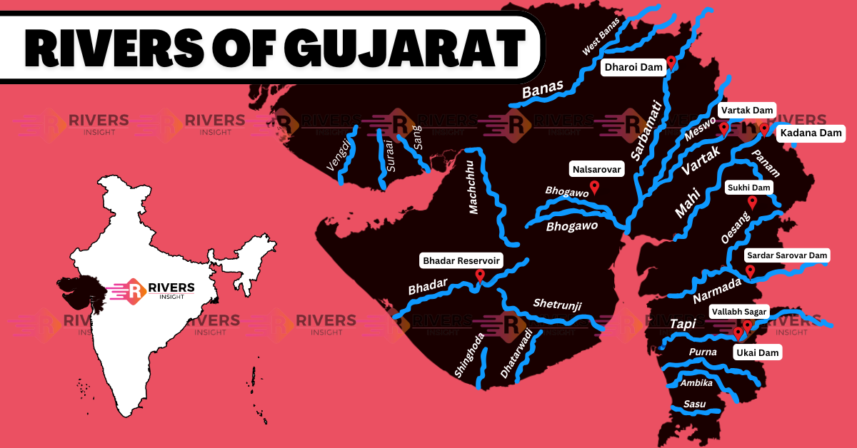
Rivers of Gujarat on the Map

Major Rivers of Gujarat
1. Narmada River
- Origin: Narmada Kund, Amarkantak, Madhya Pradesh.
- Length: 1,310 kilometers.
- Course: Flows through Madhya Pradesh and Gujarat, eventually draining into the Arabian Sea.
- Historical Name: Known as the Rewa River in ancient times.
- Westward Flow: Along with the Tapti and Mahi rivers, the Narmada is one of the longest westward-flowing rivers in India.
- Waterfalls: Known for the beautiful Kapildhara Waterfalls, where the river cascades over a cliff.
2. Sabarmati River
- Origin: Aravalli Ranges, Udaipur district, Rajasthan.
- Length: Approximately 371 kilometers.
- Course: Flows through Rajasthan and Gujarat, ultimately meeting the Gulf of Khambhat in the Arabian Sea.
- Religious Significance: Believed to be the place where Lord Shiva brought Goddess Ganga into Gujarat, giving life to the river.
- Historical Importance: Home to the Sabarmati Ashram, established by Mahatma Gandhi.
- Major Cities: Ahmedabad is one of the key cities along its banks.
3. Mahi River
- Origin: Madhya Pradesh, near the Vagad region of Rajasthan.
- Length: 583 kilometers.
- Course: Flows through Rajasthan and Gujarat before emptying into the Arabian Sea.
- Direction: Initially flows northwards through the Dhar and Jhabua districts in Madhya Pradesh.
- Drainage Area: The river’s drainage area spans 34,482 square kilometers.
4. Tapi River
- Origin: Satpura Range, Madhya Pradesh.
- Length: 724 kilometers.
- Course: Flows westward, passing through Maharashtra, Gujarat, and Madhya Pradesh, and eventually drains into the Arabian Sea.
- Position: It runs south of the Narmada River and is one of the major westward-flowing rivers in India.
5. Machchhu River
- Origin: The river originates from the Madla Hills in Gujarat.
- Length: It flows for a total distance of 130 kilometers.
- Course: The river ultimately empties into a basin that covers an area of 2,515 square kilometers.
- Historical Significance: In 1979, the Machchhu Dam wall collapsed, resulting in a tragic flood in Morbi.
Minor Rivers of Gujarat
In addition to the major rivers, Gujarat also has several minor rivers that contribute significantly to local irrigation and water supply. These include:
- Vengdi
- Suraai
- Sang
- Dhatarwadi
- Bhikada
- Ambika
- Daman Ganga
- Hiren
- Sasu
- Kosambi
- Dhadhar
- Rupen
What are your thoughts on the rivers of Gujarat? Feel free to share your comments, questions, or experiences with these rivers in the comment section below!


Wow….. awesome details. I loved it.