Subarnarekha River: Map, Origin and Course
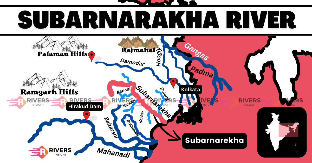
Subarnarekha River is an important east-flowing river in India, flowing through Jharkhand, Odisha, and West Bengal. Locally known as the “Golden Strike” because of the region’s gold deposits, it holds both cultural and economic significance. The river is situated between two major rivers: to the north, it lies next to the Damodar River, while the Brahmani and Baitarani rivers flow to the south.
| River | Subarnarekha |
| Length | 395 km |
| Origin | Jharkhand |
| Famous for | Hundru Falls |
| Dams | Chandil, Hundru, etc. |
Table of Contents
Geographical Features of Subarnarekha River
Origin and Course of Subarnarekha
The Subarnarekha River originates near Nagri village in the Ranchi district of Jharkhand, at an elevation of 600 meters above sea level. From here, it flows eastward through the Chhotanagpur Plateau, a region rich in mineral resources like copper. As it moves across this plateau, the river passes through Hundrugbagh Waterfall, which marks its exit from the plateau.
The river then continues its flow through three states and several key cities before reaching its final destination:
States the Subarnarekha flows through:
- Jharkhand
- Odisha
- West Bengal
Cities along its course:
- Ranchi (Jharkhand)
- Jamshedpur (Jharkhand)
- Chaibasa (Jharkhand)
- Bhadrak (Odisha)
- Kirtania Port (Odisha)
After covering a distance of 395 kilometers, the Subernarekha finally drains into the Bay of Bengal at Kirtania port in Odisha. Along the way, it is joined by several important tributaries, including the Kanchi, Kharkai, and Karkari rivers.
Drainage Basin of Subarnarekha
The Subarnarekha River Basin spans across 29,196 square kilometers, covering parts of Jharkhand, Odisha, and West Bengal. This vast basin is important not only for its water supply but also for the agriculture and industries in the region.
Geographically, the Subarnarekha Basin lies between the Damodar River to the north, and the Brahmani and Baitarani rivers to the south. To the west, it’s bordered by the Chhotanagpur Plateau, and to the southeast, it flows into the Bay of Bengal.
In addition, a large part of the basin, around 53.76%, is used for farming, while water bodies cover about 2.39% of the area.
Tributaries
Here’s the list of tributaries of the Subarnarekha River:
- Kanchi River (Right Bank)
- Karkari River (Right Bank)
- Kharkai River (Right Bank)
- Raru River (Right Bank)
- Garru River (Right Bank)
- Dulang River (Left Bank)
Notable Landmarks Along Subarnarekha River
There are several interesting places to visit near the Subarnarekha River:
- Chandil Dam: The Chandil Dam, situated near the Subarnarekha River, is renowned for its scenic beauty and recreational activities. Visitors can enjoy boating and other water sports while admiring the picturesque surroundings. Adjacent to the dam, a museum showcases ancient scripts carved on rocks, offering insight into the region’s rich history dating back 2,000 years.
- Hundru Falls: Located approximately 45 kilometers from Ranchi, the majestic Hundru Falls is a captivating natural wonder. With waters cascading from about 98 meters, it’s a favorite spot for nature enthusiasts and photographers seeking breathtaking views and serene surroundings.
- Bhavnatha Mahadev Temple: Nestled along the banks of the Subarnarekha River, the Bhavnatha Mahadev Temple is a spiritual haven dedicated to Lord Shiva. Devotees visit this temple seeking solace and tranquility, surrounded by the serene ambiance of nature.
- Chota Nagpur Plateau Hill Station: The Chota Nagpur Plateau region features a charming hill station, offering a peaceful retreat from urban life. Popular among tourists, this hill station boasts breathtaking vistas and a refreshing atmosphere, making it an ideal destination for nature lovers and adventure seekers alike.
Finally, the Subarnarekha River, which originates in Jharkhand and flows through West Bengal and Odisha, demonstrates a wide range of geographical features. It starts near Nagri village, meanders through valleys and plains, and finally empties into the Bay of Bengal after about 395 kilometers.
I hope the information was helpful! If you have any questions or would like further details, feel free to leave a comment or ask. Your feedback is always appreciated!