Ganga River System of India: Map & Tributaries
The Ganga River, also known as the Ganges, is the longest river in India, stretching about 2,525 kilometers. It originates from the Gangotri Glacier, near Gaumukh in Uttarkashi, and is initially known as the Bhagirathi. The river is called the Ganga once it joins the Alaknanda River at Devprayag.
In this article, we will examine the Ganga River System from its source to its endpoint. We will trace its route across India using a map, highlighting important places where it meets other rivers, known as Prayags. We will cover its main tributaries, such as the Yamuna, Ghaghara, and Kosi, as well as its distributaries like the Hooghly River.
| River | Ganga River |
| Length | 2,525 km |
| Origin | Gangotri Glacier |
| Distributary | Hooghly River |
| Tributaries | Yamuna, Kosi, Gandak, etc. |
| Ends in | Bay of Bengal |
Table of Contents
Ganga River System
The Ganga river system is a vast and complex network of rivers, streams, and wetlands spanning India, Tibet (China), Nepal, and Bangladesh. It covers an area of over 861,000 square kilometers, making it the largest river basin in India. The system supports a rich biodiversity and provides a range of ecosystem services.
Origin of River Ganga
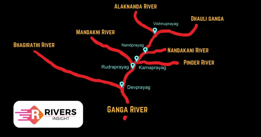
The Ganga River begins its journey from the Gangotri Glacier, located near Gaumukh in the Uttarkashi district of Uttarakhand, India. At first, the river is called the Bhagirathi. However, when it meets the Alaknanda River at Devprayag, it takes on its famous name – the Ganga.
Course
At Devprayag, the Bhagirathi meets the Alaknanda River, which originates from the Satopanth Glacier above Badrinath. This confluence marks the point where the river is named the Ganga. The Alaknanda River is formed by the convergence of the Dhauli and Vishnu Ganga rivers at Joshimath (Vishnu Prayag), contributing to the Ganga’s flow.
Further along, at Karna Prayag, the Pindar River, a tributary of the Alaknanda, merges with the Ganga. The Mandakini River (also known as Kali Ganga) then joins the Alaknanda at Rudra Prayag, marking another significant confluence.
Approaching the Bay of Bengal, the Ganga splits into two major distributaries: the Bhagirathi and the Padma, forming an extensive delta system before emptying into the sea.
| Prayag | River Confluence |
|---|---|
| Devprayag | Confluence of Alaknanda and Bhagirathi Rivers |
| Rudraprayag | Confluence of Alaknanda and Mandakini Rivers |
| Karnaprayag | Confluence of Alaknanda and Pindar Rivers |
| Nandprayag | Confluence of Alaknanda and Nandakini Rivers |
| Vishnuprayag | Confluence of Alaknanda and Dhauliganga Rivers |
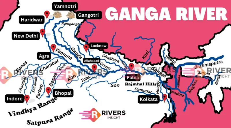
States through which the Ganga River Flows
The river flows through various states, including:
- Uttarakhand- 110 km
- Uttar Pradesh- 1450 km
- Bihar- 445 km
- West Bengal- 520 km
Map of Ganga River System with Tributaries
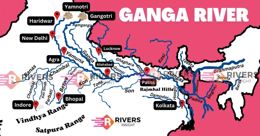
Tributaries of Ganga River
The Ganga River, which spans a basin area of about 1.1 million square kilometers across India, Nepal, China, and Bangladesh, is fed by several important tributaries. The tributaries are divided into those flowing into the left bank and the right bank of the Ganga. Key tributaries include the Yamuna, Ghaghara, Kosi, and Son, etc. Below, we discuss each tributary in detail.
Left Bank Tributaries
Below are the left-bank tributaries that flow into the Ganga River from the left side:
1. Ramganga
- Origin: The Ramganga River originates in Uttarakhand, India.
- Course: The river flows through the foothills of the Himalayas, passing through Uttarakhand and Uttar Pradesh.
- Length: It travels a distance of approximately 596 kilometers before joining the Ganga River.
- Confluence: The Ramganga merges with the Ganga River near Kannauj in Uttar Pradesh.
- Tributaries: It has several smaller tributaries, including the Koshi, Gangan, Deoha, Gagas, Aril, etc.
2. Gomti
- Origin: The Gomti River originates from the Gomti Taal (pond) in the Pilibhit district of Uttar Pradesh, India.
- Course: It flows southeast through the state of Uttar Pradesh and the city of Lucknow before merging with the Ganga River near the town of Saidpur in Ghazipur district.
- Length: The Gomti River has a length of approximately 900 kilometers.
- Tributaries: A major tributary of the Gomti River is the Sai River.
3. Ghaghara
- Origin: The Ghaghara River originates from the Tibetan Plateau, near the source of the Kerang Glacier in the Tibet Autonomous Region of China.
- Course: It flows through Nepal and enters India, where it travels through the northern part of Uttar Pradesh.
- Length: The Ghaghara River has a length of approximately 507 kilometers.
- Confluence: It merges with the Ganga River near the town of Chhapra in Bihar, India.
- Tributaries: Important tributaries of the Ghaghara include the Sarda (or Sharda) River and the Seti River.
4. Gandak
- Origin: The Gandak River originates in the Tibetan Plateau,
- Course: It flows southeast through Nepal and then enters India.
- Length: The Gandak River has a length of approximately 630 kilometers.
- Tributaries: Major tributaries of the Gandak are Mayangadi, Bari, Trisuli, Panchand, Sarhad, Budhi Gandak.
5. Kosi
- Origin: The Kosi River originates from the Tibet Autonomous Region of China and flows through Nepal before entering India.
- Course: The Kosi traverses the northern plains of Bihar in India, where it merges with the Ganga River near the town of Kursela.
- Tributaries: The Kosi has several tributaries, including the Sun Kosi, Tamur, and Arun rivers.
Right Bank Tributaries
Below are the right-bank tributaries of the Ganga that flow from the right side:
1. Yamuna River
- Origin: The Yamuna River begins in the Yamunotri Glacier, located in the western Himalayas of Uttarakhand, India. Its source is at an elevation of around 6,387 meters.
- Course: Flowing southward, the Yamuna passes through the states of Uttarakhand, Himachal Pradesh, Haryana, and Delhi. It eventually merges with the Ganga River at Allahabad, Uttar Pradesh.
- Length: The Yamuna extends approximately 1,376 kilometers from its source to its confluence with the Ganga.
- Tributaries: Notable tributaries of the Yamuna include the Tons, Chambal, Betwa, and Ken rivers.
2. Son River
- Origin: The Son River starts from the Amarkantak Plateau in Madhya Pradesh, India.
- Course: It flows west and then south through Madhya Pradesh and Uttar Pradesh, eventually joining the Ganga River near Patna in Bihar.
- Length: The river is about 784 kilometers long.
- Tributaries: It has several smaller tributaries, including the Rihand and Koel rivers.
3. Damodar River
- Origin: The Damodar River originates from the Chotanagpur Plateau in the state of Jharkhand, India.
- Course: It flows westward through Jharkhand and then south into the state of West Bengal before joining the Hooghly River, a distributary of the Ganga.
- Length: The river stretches approximately 592 kilometers from its source to its confluence with the Hooghly.
- Tributaries: Major tributaries of the Damodar include the Barakar and the Konar rivers.
Distributaries of Ganga
A distributary is a branch of a river that diverges from the main river and flows away from it, often forming a network of channels. In the Ganga River’s case, several distributaries emerge as it approaches its delta and empties into the Bay of Bengal.
- Hooghly (Hugli) River: This is a major distributary of the Ganga River. It branches off near the city of Kolkata and flows southward through West Bengal before emptying into the Bay of Bengal.
- Padma River: This is the name for the Ganga River once it enters Bangladesh. The Padma flows through the southwestern region of Bangladesh.
- Meghna River: Formed by the confluence of the Padma and Jamuna (Brahmaputra) rivers, the Meghna River flows through Bangladesh and is a key part of the delta system.
Conclusion
In conclusion, the Ganga River is perennial, meaning it flows throughout the year, supported by its snow-fed source in the Himalayas. Its course through the Indo-Gangetic Plain is characterized by its meandering path, shaped by its high sediment load and the flat topography of the plain.
Because the Ganga River is very important for our country’s culture, environment, and economy, the government has started many projects to protect and conserve it. One such project is the Namami Gange Programme, which aims to clean the river’s water, restore its natural health, and promote sustainable development along its banks.
Moreover, the government has also set up a high-level committee called the National Ganga Council to oversee these efforts and ensure the river’s long-term sustainability. Through these efforts, the government is trying to balance the river’s importance with the needs of the millions of people who depend on it.